|
This page is about a weekend of long distance, outdoor activities on the eastern shore that I call my "Challenge Weekend." |

|
This page is about a weekend of long distance, outdoor activities on the eastern shore that I call my "Challenge Weekend." |
|
I had been reading about the various feats Jack LaLanne has accomplished. He is not one to let age slow him down. Feeling inspired (and a little old), I decided it was time for me to push myself physically.
What to do? There are two things I've been wanting to do. One is to circumnavigate Chincoteague Island via kayak. The other is to do a century (100 mile) bicycle ride. With no better time than the present, I explored both options. I did my kayaking preparation: I also did my bicycling preparation:  |
|
I left work a little early to ensure I would make it to Tom's Cove Campground before dark. I arrived with about an hour of daylight left. My campsite was B2. I asked for something near the boat ramp and by golly that is what they gave me. Only B3, B4, and B5 were closer. The site was small but big enough for me, my car, and my tent. The restroom wasn't far away.
There was a good breeze that made setting up the tent a bit challenging but it also kept away the mosquitos...that is, until I went into the restroom where there was no breeze. Then I was attacked by numerous blood suckers. I also saw several insects about an inch long in the sink. I had never seen anything like them before and still have yet to identify them. There was a 1.25-inch long horsefly in the restroom also. I was not wanting to spend anymore time in there than I absolutely needed. Next time I will spray down before entering. I caught up on some reading and ate an MRE. A little later, my neighbors at B3 offered me spaghetti but I was done eating for the night. I was in bed by 2100. |
|
I was up before 0600. But high tide at the north end wouldn't be until about 1400 so I spent the morning scouting for launch sites.
I launched at 1100 from Tom's Cove. There was a considerable amount of boat traffic and the water was choppy. I tried to hug the shore to keep out of their way. The wind was blowing at 15 mph from the east. Since the open water is mostly north and south, the wind wouldn't be much of a problem. I paddled clockwise. For the first couple of miles, I was paddling against the tide. I rounded the southern tip then caught the flood tide which pushed me north in the Chincoteague Channel. Boat traffic was very heavy for about three miles. What made it challenging is that I couldn't get too close to the shore because of all the fishing lines. Sometimes I would encounter a fishing boat anchored which meant I had to get further out into the heavy boat traffic. I encountered up to 2.5 foot wakes. But it was fun. I was still fresh and enjoying the challenge. That's why I was paddling clockwise. I wanted to get the roughest part done first. After I got north of the route 175 bridge, boat traffic mostly died out. Rather than paddle through Lewis Channel and hug the shore, I ventured out into Chincoteague Bay. I was now paddling on the west side of tidal flats. They were comprised of a mix of sand, grass, and oyster shells. 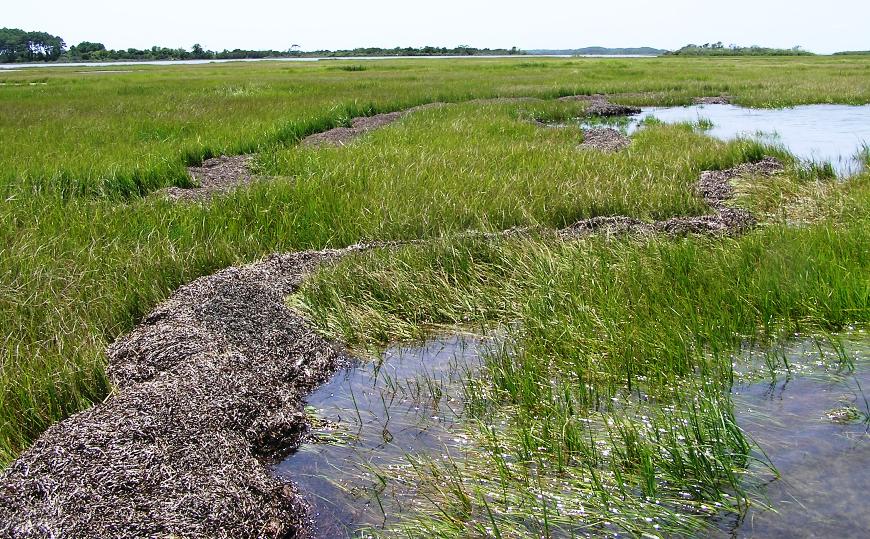
I saw several brown pelicans (see the cover photo). This is the first time I've seen them on the east coast. They looked smaller than their California cousins. Getting around the northern tip of the island, Wildcat Point, reminded me of the first few times I hiked Twin Bridges. See July 29, 2008 for my most recent hike there. Getting to the top is a tease in that it looks like it is just a short distance away but then once I get there, I realise it is further. This goes on for quite some time until I really do reach the top. Well Wildcat Point on Chincoteague is the same way. I kept thinking it was just after the next marsh, then after the next one, and so on. This went on for some time and my concentration started to fade. I checked my GPS and realized that I paddled past Chincoteague and was now at Assateague Island! So I had to backtrack. Now that I was facing south, it was obvious that I missed my turn. I'm thinking I paddled an extra 1.5-2 miles because of this. I was now kayaking south in the Assateague Bay, catching the ebb tide. I hugged the Assateague side which was more natural and scenic. Though I originally started out thinking I would make good time, I now felt it was best to enjoy the scenery and take a more casual pace. The place was full of egrets. I also saw numerous crabs swimming near the surface. I thought about how the crab population in the Chesapeake Bay has more than doubled over the last two years. After paddling under the Maddox Boulevard bridge, the boat traffic picked back up again. Not much further. By 1530, I was done. I paddled 22.7 miles, averaging a mere 5.1 mph. I was hoping for at least 5.5 mph. I reckon that if I paddled through Lewis Channel, and if I didn't miss my turn at Wildcat Point, I could have done it in 21 miles. I don't know how the fellow in that article I read stretched it out to 26.5 miles. I was mentally prepared for up to 30 miles so this trip seemed pretty easy. But it was also fun. I just wish I had seem some dolphin. I've never seen any while kayaking. I spoke to my neighbor at campsite B1. He spent over 29 years in the Army and had just retired 10 days ago. He said he has never seen so much boat traffic at the island as this weekend. But by October, he assured me there would be very little. |
|
After eating another MRE, I set out to do a little more exploring. This time, I headed out to Chincoteague NWR. The traffic out there was hideous. I really hit a busy tourist weekend. I think it had to do with the fact that the entrance fee to the NWR was waived for the weekend.
I noticed that the NWR is very bicycle-friendly. There are several paved bike paths that run parallel to the road but separated by the tree line. I stopped at one short trail but just long enough to read a sign. 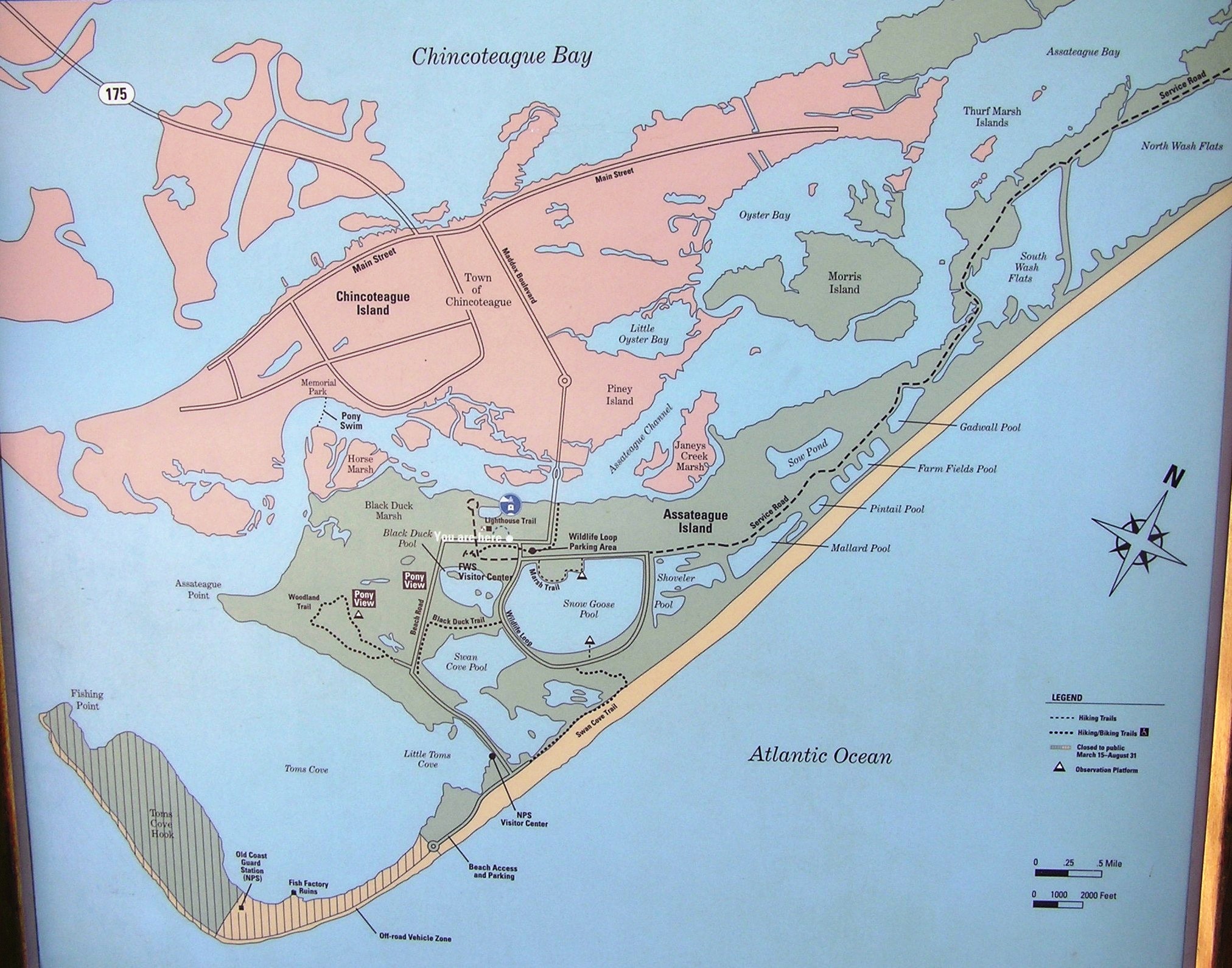
It seems there are a good number of short trails and places to explore in the NWR. I expect I will return with my bicycle in October and spend one day bicycling and hiking rather than kayaking. There is just sooo much to see and I want to get a well-rounded exploration experience. There were numerous large ponds on the island. They are very scenic and pristine. Unfortunately, one cannot paddle there being as they are protected...I guess that is part of the reason they are so pristine. But you can launch on the beach and in Toms Cove. Launching from the beach will put you out in the ocean to play in the waves. I believe one can launch into Little Toms Cove from Toms Cove Visitor Center which is on the south side of Beach Road, right before the beach. I believe there may be seasonal restrictions. On the way out, I stopped to photograph some egrets at Swan Cove, one of the places off limits to boats. 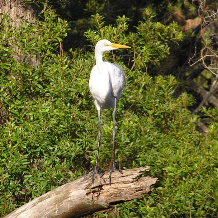
A little later, I saw some wild ponies way out yonder. I ate another MRE and was in bed by 2030. |
|
I woke up naturally at 0515. I was feeling pretty good about circumnavigating Chincoteague Island yesterday and that was a good way to start the day. I packed my tent in the dark then left. I headed north, back into Maryland. My goal for the day was to do a century ride on the ViewTrail 100.
There are many places I could have started the ride. I didn't want to start where the directions state because I would waste too much morning sun driving so far north. Hence, I decided to start in Pocomoke City at Winter Quarters Golf Course Landing. This is a great place to launch on the Pocomoke River because it puts one just a mile downstream of Dividing Creek. I paddled this creek on June 21, 2009 and saw more snakes than I'd ever seen before while kayaking. In terms of narrow creek scenery, this is as good as it gets. Unfortunately, when I paddled it last year, we turned around after about 1.75 miles at Dividing Creek Road (route 364). I'm thinking I would like to do it again in October on the last day of my big kayaking weekend, but this time go considerably farther. I would bring a saw, loppers, and Ivy Block. Some portaging might be involved but I have no doubt it will be worth it. |
|
I started at 0710, biking the route I chose, heading clockwise. That is mainly because the directions are written for heading that direction. One reason I started in Pocomoke City is because I wanted to make sure the most difficult part of the ride was at the beginning, when I was still fresh. When I say "difficult" I don't mean physically. The hardest part of this ride is navigating. I studied the map before coming out here and I knew that the first few miles after leaving Pocomoke City were confusing. By doing this early, I would hopefully get through it easily. However, that was not the case. There was one section that took me three tries before I finally got on the right route. Ironically, my first choice was right but I doubted myself and thought I was wrong. The lack of road signs makes it all the more frustrating.
Having made it through the worst part, I could now enjoy the scenery. There were lots of corn fields, soybean fields, and chicken farms. Unfortunately, there was also the smell of chicken farms. But there were also other birds...turkey vultures. I saw several, including many that seemed to think someone died in this house. 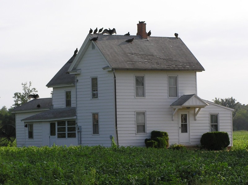
I had never done a century ride. The longest ride I had ever done previously was about 75 miles and that was 20 years ago! So I was taking it easy, drinking lots of fluids, and taking lots of breaks. But I wasn't intending to take so many breaks. I just had to stop frequently to check directions. Next time, I'll program all the turns into my GPS. The biggest morale booster in the ride was making it to mile 50. Even though that means I still have 50 miles to do, I know that I am halfway done and for me, mentally, that means a lot. I was also feeling pretty good at mile 50. Now I didn't have any doubt I wouldn't finish. It was just a matter of time. I made it to the northernmost part of the ride in Berlin. Up to now, my ride had been pretty quiet. But there was quite a lot going on in the town. The atmosphere was festive. There were lots of folks out walking around and I heard music. I would have loved to stay and explore but I had to take care of first things first. I crossed the Pocomoke River at Whiton Crossing Road. This is five miles upstream of Porters Crossing Road. I've never paddled upstream of Porters Crossing Road and had been curious what the river looked like upstream. It actually didn't look too bad. Certainly paddle-able. Maybe I'll look into this more some other time. I got the feeling Chip might be willing to join me for such an adventure. I found an osprey tail feather...a mighty fine specimen. 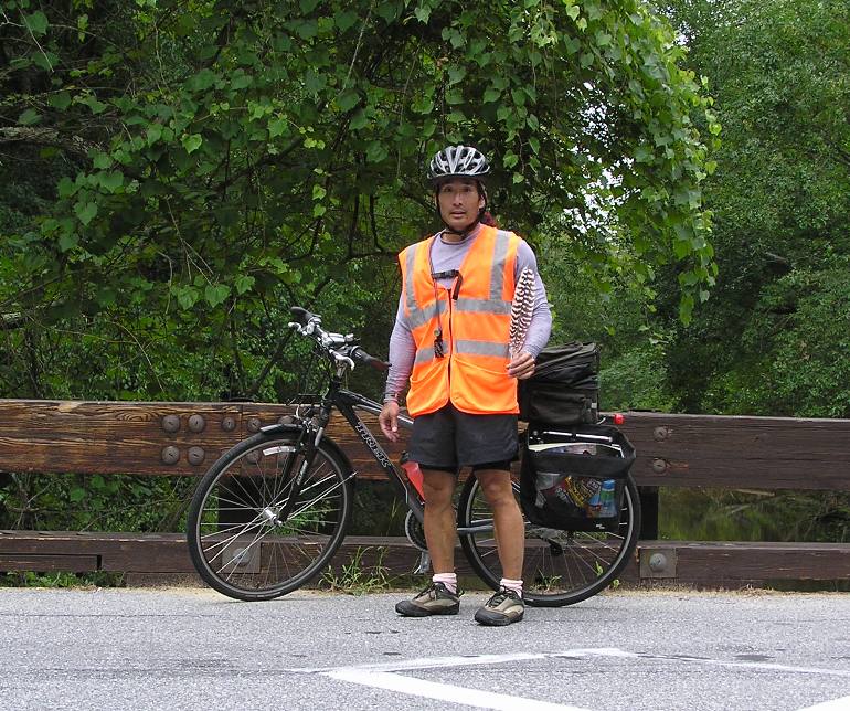
I crossed over Nassawango Creek at Old Furnace Road. This land is part of the Nassawango Creek Preserve. I expect I will return someday to explore this, the Paul Leifer Trail, and the Old Iron Furnace which are all located at Old Furnace Road and Millville Road. While I'm at it, I should also check out the half mile Pusey Branch Nature Trail which is on the north side of Old Furnace Road just east of its intersection with Old Beech Road. The Pusey Branch is a tributary of the Pocomoke River. Around mile 72, I started to cramp up. I had been drinking nothing but a mixture of Gatorade and water. I was also eating salty snacks. But now I wish I had saved those salt packs from the MREs I ate earlier. If I rode at a moderate and consistent pace and took breaks, I was fine. But if I tried to go fast, I would cramp up. Also, the forceful jerk to free my shoes from the toe clips on the pedals made my legs cramp so I quit using the toe clips. At mile 75, I biked past a house with a fairly large, muscular dog out front. He was looking at me in a not-so-friendly manner. I knew that if he started chasing me I would have to haul ass to get away. Then I would cramp up, not be able to pedal, and possibly get attacked by the dog. Then the dog started running after me. After running about ten feet, the owner yelled its name and it stopped. Next time I will definitely bring salt packets. I was now riding through lots of trees. The shade was nice. It was also good to get away from the nine mph southeast headwind. Around mile 82, Norma called. She told me our neighbor passed away. We spoke for about 20 minutes. Though the news was sad, the break gave me enough time so that cramps were no longer a problem for the rest of the ride. I biked over Dividing Creek at Dividing Creek Road (route 364). I saw the section where we turned around last year when kayaking. It was still as pretty as ever. 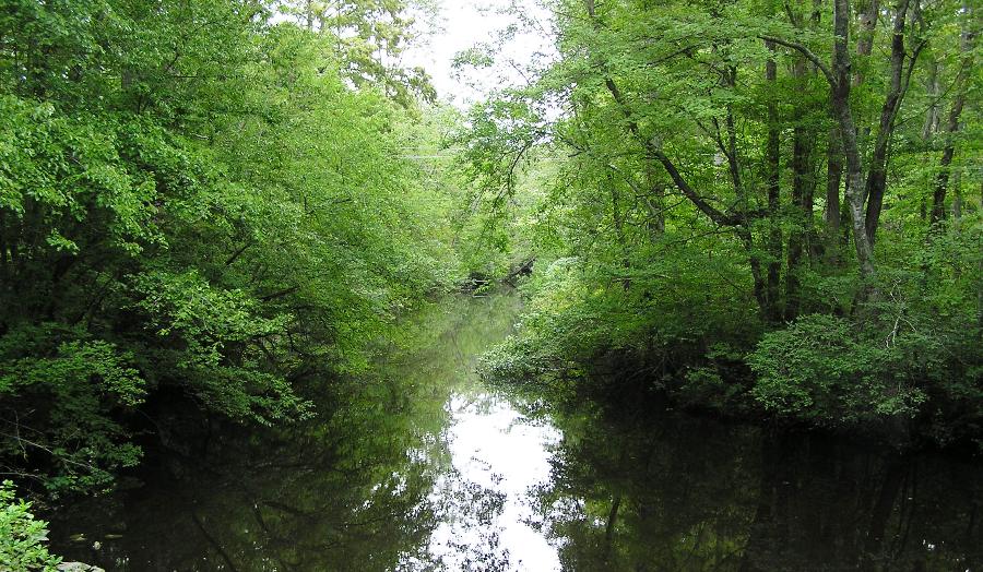
I reached mile 100 after nine hours. But keep in mind that much of this was spent stopping to read maps, take photos, eat, and talk on the phone. I think if I did this again, I would shoot for 6.75 hours. But I still wasn't done. I had another six miles to go...probably because I wasted so much time taking wrong turns. I finished after nine hours and 35 minutes. My moving average was 12.6 mph and my overall average was a mere 10.8 mph. Except for those 10 miles where I was having problems with cramping, I felt pretty good. My butt was sore but that's to be expected. I don't think I would want to ride more than 100 miles but I would certainly ride that distance again only faster, or perhaps over a more challenging route. I stopped in at the Pocomoke City Pizza Hut where I ate two-thirds of a large meat-lovers pan pizza and drank about a quart of Diet Pepsi. I can't remember the last time food and drink tasted so good. |
|
It felt good to accomplish my goals over the self-imposed Challenge Weekend. I'm already thinking of what I can do next year. Perhaps it will involve paddling the Pocomoke River from Porters Crossing Road to the Pocomoke Sound. Or maybe circumnavigating Saint Michaels with a portage across the isthmus. I've got plenty of time to think about it.
|