Biking Routes

This page describes some of my favorite bike routes in the mid-Atlantic region. All these routes are suitable for hybrid or similar bicycles. Titles shown in red are pending completion.

In the photo above, I am towing Daphne while bicycling with Norma on March 13, 2021. We rode from Merganser Pond to Midway Branch and back in Patuxent Research Refuge - North Tract, Maryland. Daphne doesn't much enjoy being stuck in her carrier so we make a lot of stops so she can stretch her legs and sniff around.

I used to have lots of cue sheets. Now I realize that there are many phone apps that automate this process and allow the information to be shared with other devices. I expect it is just a matter of time before I start using this technology and share it via this web page. But I'm not there yet. If you have suggestions for such apps that are free, easy to use, and interact with a wide range of devices (including desktops), please let me know.

See map for all the bike routes that I have documented.

About this web pageOpen accordion icon
This state-centric page describes the bicycling routes I've ridden or intend to ride in the mid-Atlantic region. It is very focused on Maryland and Washington, D.C. Please send me an email if you find
  • Incorrect information that I've listed.
  • Broken links.

  • I do not intend to list every bike route in the mid-Atlantic region but if I've biked it, I will list it along with some good places to access the route.


    In 2021-2022, I started using a Google Maps application programming interface (API) to simplify the reporting process, linking my notes to a map that also links back to my notes. I also spent a lot of time learning JavaScript so I could create clickable maps to enable readers to find access points using a graphical user interface (GUI). Hopefully, the time I invested into creating this website will make it easier for you to find and get to your destination, thereby minimizing your effort and maximizing your time and enjoyment bicycling.

    For the maps that I've created, left click on the marker to display a choice of hyperlinks:
    Get Directions: Clicking this pulls up a Google Maps page that will show the access point and allow you to click on the "Directions" button so you can enter your location and get directions to the access point or parking area.
    Saki notes: Clicking this will take you back to my text writeup of the route where you may find links to my blogs for this area.

    I tried to be thorough in reporting the location of the access point and where to park. I often do not report hours and fees because they are subject to change so I recommend checking out any links I post to get this information. Pay attention to the "Date last updated" field. If it is recent, you can be assured it is accurate, but things change over time so if I haven't been there for awhile, then don't take my word as law.

    Happy bicycling!
    Close accordion icon


    Delaware


    Chesapeake and Delaware (C&D) Canal, Michael N. Castle Trail, and Ben Cardin Recreational Trail

    Georgetown-Lewes TrailOpen accordion icon
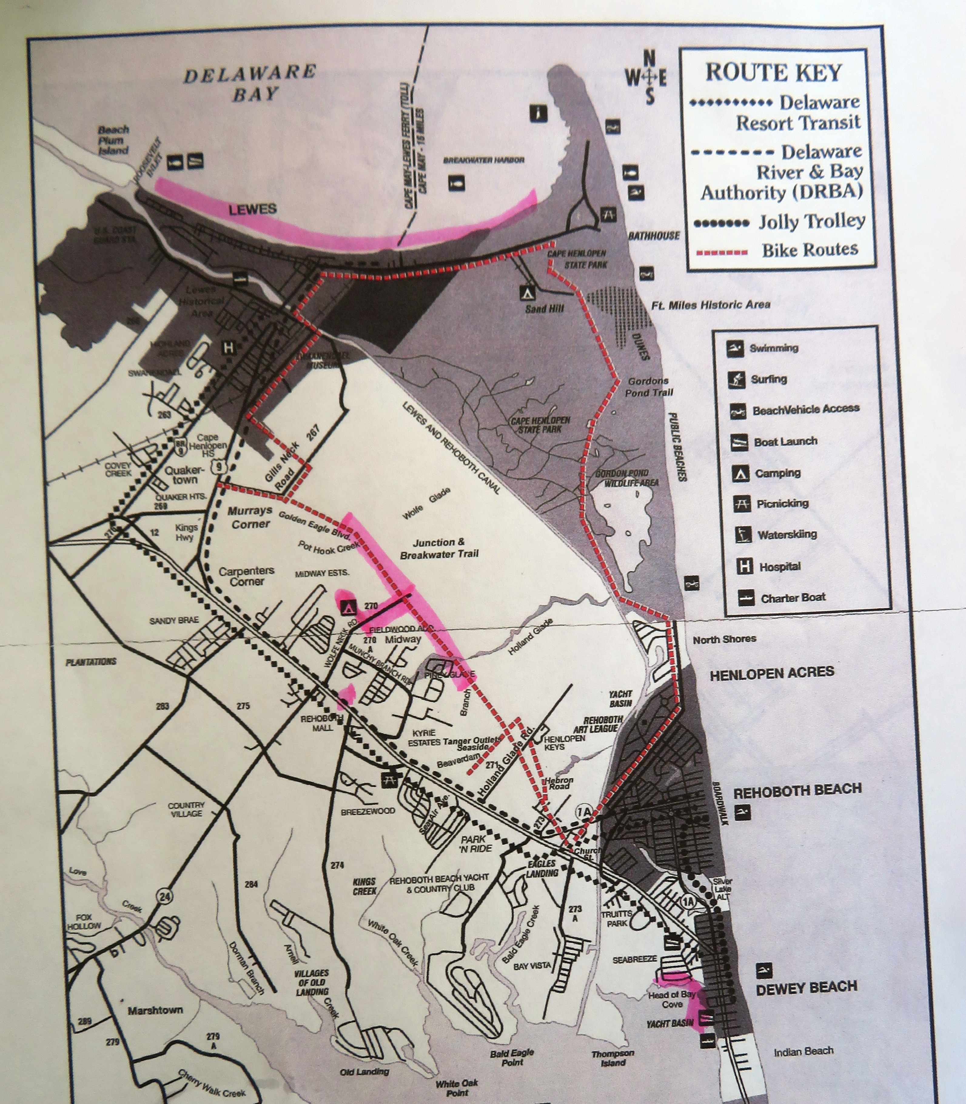
    LOCATION: As of 2024, this Sussex County, Delaware trail goes from Lewes to Milton. Eventually, it will extend to Georgetown.

    DATE LAST UPDATED: June 17, 2024

    NOTES: This ~10-mile trail can be linked with other trails/roads to form a scenic and easy 15-mile loop.

    BLOGS: June 17, 2024

    ADDITIONAL INFORMATION: Delaware Greenways - Georgetown-Lewes Trail
    TrailLink - Georgetown-Lewes Trail
    AllTrails - Georgetown-Lewes Trail
    Wolfe Neck / Gordons Pond route

    The following sites are listed in order of north to south:

    Gills Neck Road

    Public Library
    Close accordion icon

    Gordons Pond TrailOpen accordion icon
    LOCATION: Cape Henlopen State Park to Rehoboth Beach, Sussex County, Delaware.

    DATE LAST UPDATED: June 17, 2024

    NOTES: This 5.2-mile gravel trail can be linked with other trails/roads to form a scenic and easy 15-mile loop.

    BLOGS: June 17, 2024

    ADDITIONAL INFORMATION: Delaware Greenways - Gordons Pond Trail
    TrailLink - Gordons Pond Trail
    Delmarva Trails & Waterways - Cape Henlopen State Park: Gordon's Pond Trail
    Wolfe Neck / Gordons Pond route

    The following sites are listed in order of north to south:

    Dune RoadOpen accordion icon
    LOCATION: Parking on the east and west sides of Dune Road near Fort Miles Battery Smith. Sussex County ADC map 19 B5. See map.

    NOTES: This is about 0.2 mile south of the north trail terminus.
    Close accordion icon

    Ocean DriveOpen accordion icon
    LOCATION: Just southeast of Gordon Pond on the east side of Ocean Drive, 0.3 mile north of where Ocean Drive meets Farview Road. Sussex County ADC map 19 B10. See map.

    NOTES: The specific city and zip code varies depending on the map. Answers could be Lewes, Henlopen Acres, or Rehoboth Beach. There is a tremendous amount of parking at this location which serves both the beach and the trail. The trailhead is on the northwest side of the lot.
    Close accordion icon
    Close accordion icon

    Junction and Breakwater TrailOpen accordion icon
    LOCATION: Rehoboth Beach to Lewes, Sussex County, Delaware.

    DATE LAST UPDATED: June 17, 2024

    NOTES: This 5.8-mile trail can be linked with other trails/roads to form a scenic and easy 15-mile loop.

    BLOGS: June 17, 2024

    ADDITIONAL INFORMATION: Delaware Greenways - Junction & Breakwater Trail
    Lewes Chamber of Commerce - Junction and Breakwater: Biking and Hiking Trail
    TrailLink - Junction & Breakwater Trail
    AllTrails - Junction and Breakwater Trail
    Wolfe Neck / Gordons Pond route

    The following sites are listed in order of north to south:

    Gills Neck RoadOpen accordion icon
    LOCATION: 300 Gills Neck Road (route 267), Lewes, Delaware 19958. This trailhead resides 140 feet east of where Gills Neck Road meets Schley Avenue. Sussex County ADC map 18 F5. See map.

    NOTES: This is the northwestern endpoint of the trail. From here, one can also access the Georgetown-Lewes Trail. I don't know how much parking resides at or near this location.

    According to Delaware Greenways - Junction & Breakwater Trail:
    The western endpoint on Gills Neck Road is a short walk/ride from downtown Lewes. A bicycle parking area with informational kiosk can be found at the corner of Gills Neck and Savannah Road. Leave your bikes and enjoy downtown Lewes. Public bathroom facilities and water fountains can be found off of Pilottown Road. More info can be found on the Lewes Chamber of Commerce website.
    From the endpoint on Gills Neck Road you will also find an entrance to the Georgetown-Lewes Trail. The Lewes Library Trailhead with bathrooms, water fountains, informational kiosk, bike station and plenty of parking can be found about a quarter of a mile from its start on Gills Neck Rd.
    Close accordion icon

    Public LibraryOpen accordion icon
    LOCATION: 111 Adams Avenue, Lewes, Delaware 19958. Sussex County ADC map 18 E6. See map.

    NOTES: Park at the public library as far north as possible. Room for ~100 vehicles. Public restroom available outside the building. Bike southeast on Monroe Avenue for 300 feet to access the trail.

    This is also a good location to pick up the Georgetown-Lewes Trail.
    Close accordion icon

    Wolfe Neck RoadOpen accordion icon
    LOCATION: 35536 Wolfe Neck Road, Rehoboth Beach, Delaware 19971. The parking lot is on the south side of Wolfe Neck Road, 0.4 mile northeast of where Wolfe Neck Road intersects Rusty Anchor Drive. Sussex County ADC map 18 H10. See map.

    NOTES: On some maps, "Wolfe" is spelled "Wolf." Parking for ~40 vehicles. Restroom. Fee to park. Picnic tables.

    Side trail from restroom leads 0.2 mile to Junction and Breakwater Trail. Or, one can bike 0.2 mile northeast on Wolfe Neck Road to access the trail.
    Close accordion icon
    Close accordion icon


    Maryland


    Amish 100Open accordion icon
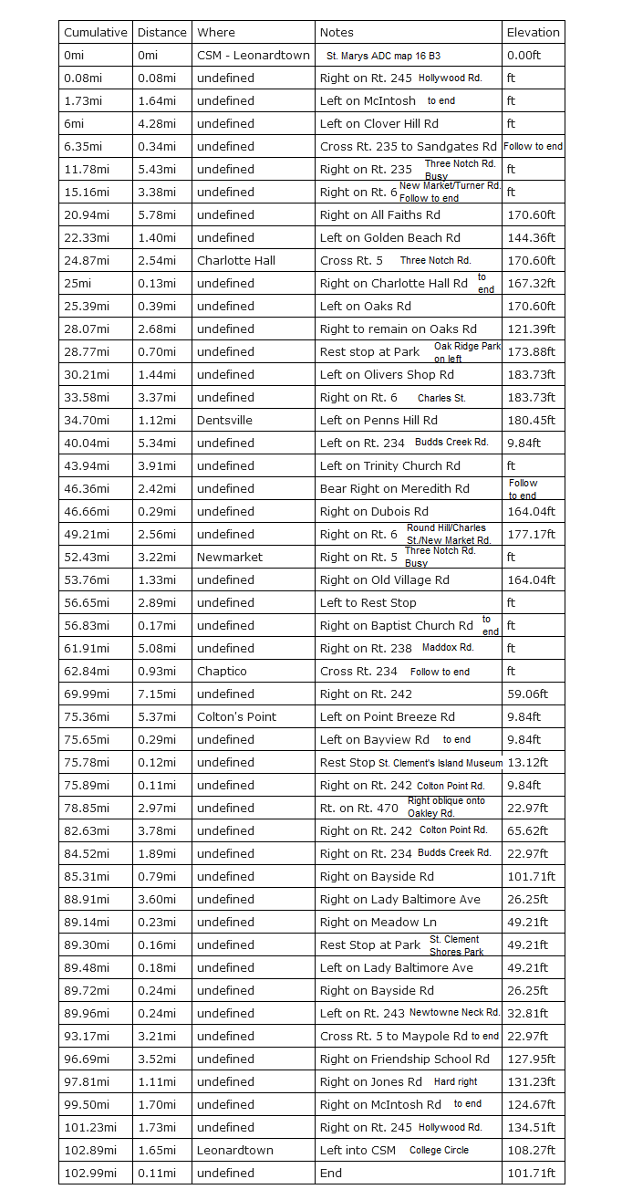
    LOCATION: The ride is roughly between Leonardtown in Saint Marys County, Maryland almost to La Plata in Charles County, Maryland.

    I choose to start and end at College Circle parking lot at the College of Southern Maryland, Leonardtown Campus which is on the southeast side of the route. Saint Mary's County ADC map 16 B3. See map.

    DATE LAST UPDATED: April 24, 2016

    NOTES: There are various rides that go by this same name. The one described here is a somewhat flat 103-mile circuit route on southern Maryland roads. It is called Amish 100 because it goes by a lot of Amish land.

    Here's a map I put together that has the mileage in green, small road names added, and possible rest stops in red. And here's a cue sheet from the source that I put into a single page where you can see everything at once. Smaller font text in the cue sheet are my notes, and not from the source. I found the mileage to be dead on accurate. My notes, not as much. There is once or twice where I say to ride to the end of the road but that is not the case though it looked that way on the map at the time. I just haven't gotten around to updating my notes. On the cue sheet, it mentions a rest stop around mile 56.65. We never found that.

    BLOGS: April 24, 2016
    Close accordion icon

    Baltimore and Annapolis (B&A)Open accordion icon
    LOCATION: This 13-16.1-mile (depending on the source) paved rail trail runs from Glen Burnie to Annapolis in Anne Arundel County.

    DATE LAST UPDATED: Before 2010

    NOTES: The northern side of the trail has higher elevation than the southern side. Consider combining this trail with the BWI Trail via the John Overstreet Connector.

    ADDITIONAL INFORMATION: Anne Arundel County - B&A Trail
    Bike Washington - Baltimore & Annapolis Trail
    TrailLink - B&A Trail: Map shows public parking access
    AllTrails - B&A Trail

    The following sites are listed in order of north to south:

    North LotOpen accordion icon
    LOCATION: The northernmost public parking lot along the trail is on the west side of Greenway Street Northwest on the northwest side of where it meets Alley 204, Glen Burnie, Maryland 21061. Anne Arundel County ADC map 5056 K4. See map.
    Close accordion icon

    Kinder Farm ParkOpen accordion icon
    LOCATION: This detour is 0.7 mile west of the B&A Trail on the south side of East West Boulevard, Millersville, Maryland 21108. Anne Arundel County ADC map 5173 F3. See map.

    NOTES: In this park, you'll find a 2.4-mile loop trail.

    ADDITIONAL INFORMATION: AllTrails - Kinder Farm Park
    Close accordion icon

    West Earleigh Heights RoadOpen accordion icon
    LOCATION: Parking the south side of West Earleigh Heights Road, 260 feet southwest of where it meets Light Street Avenue, Severna Park, Maryland 21146. Anne Arundel County ADC map 5173 J5. See map.

    NOTES: This is located near the midpoint of the B&A Trail. Here, you'll find ~21 parking spaces.
    Close accordion icon
    Close accordion icon

    Baltimore Washington International (BWI) TrailOpen accordion icon
    LOCATION: This 11-12.5-mile (depending on the source) paved trail circumnavigates the BWI Airport.

    DATE LAST UPDATED: Before 2010

    NOTES: Consider combining this trail with the B&A Trail via the John Overstreet Connector.

    ADDITIONAL INFORMATION: Bike Washington - The BWI Trail
    TrailLink - BWI Trail: Map shows public parking access.
    BWI Airport - The BWI Hiker-Biker Trail

    The following sites are listed in order of north to south:

    Andover ParkOpen accordion icon
    LOCATION: 805 Main Avenue, Linthicum Heights, Maryland 21090. Anne Arundel County ADC map 5056 E5. See map.

    NOTES: This location provides access to the north side of the trail.

    ADDITIONAL INFORMATION: Anne Arundel County - Andover Park
    Close accordion icon

    Thomas A. Dixon, Jr. Aircraft Observation AreaOpen accordion icon
    LOCATION: 1911 Dorsey Road, Glen Burnie, Maryland 21061. Anne Arundel County ADC map 5056 E5. See map.

    NOTES: This location provides access to the south side of the trail.

    ADDITIONAL INFORMATION: Anne Arundel County - Thomas A. Dixon, Jr. Aircraft Observation Area
    Close accordion icon
    Close accordion icon

    Blackwater National Wildlife RefugeOpen accordion icon
    LOCATION: Various options for this route are all centered around the scenic and natural Blackwater National Wildlife Refuge in Dorchester County.

    Many people park and commence their ride at the Blackwater National Wildlife Refuge Visitor Center, 2145 Key Wallace Drive Cambridge, MD 21613-9536. Dorchester County ADC map 29 G2. See map. Here, you'll find a restroom, plenty of parking, and route maps. But if you plan on being out after they close, you should consider one of the many other parking options at the Chesapeake Living link shown below.

    PHONE: 410-228-2677

    DATE LAST UPDATED: Before 2010

    NOTES: If you like natural scenery and hate hills, this might be a good choice. Most of it is on roads that receive light traffic. This area is popular with birdwatchers. Keep your eyes open for bald eagles.

    ADDITIONAL INFORMATION: U.S. Fish & Wildlife Service - Blackwater National Wildlife Refuge - Biking
    Friends of Blackwater National Wildlife Refuge
    Chesapeake Living - How to Soar Through Blackwater Wildlife Refuge? On a Bike!: This shows good places to park
    Ride with GPS - Blackwater National Wildlife Refuge
    Close accordion icon

    Torrey C. Brown Rail Trail / NCR TrailOpen accordion icon
    LOCATION: This 19.7-mile Baltimore County, Maryland rail trail reaches its southern terminus at Ashland Road in the Hunt Valley area (Cockeysville) to its northern terminus at the Mason-Dixon Line.

    The northernmost part of the trail ends in Pennsylvania and continues as the Heritage Rail Trail County Park.

    PHONE: 410-592-2897​

    DATE LAST UPDATED: Before 2010

    NOTES: The trail is eight to ten feet wide with a stone dust surface and little change in elevation, though the northern side is slightly higher. The most popular activities on the trail are hiking, jogging, bicycle riding, and horseback riding. While it is not paved, it is quite hard. The trail from Monkton and further south often receive heavy use on weekends and the parking in these areas may be filled by late morning on a nice day.

    In 2007, the Board of Public Works approved the renaming of the North Central Railroad (NCR) Trail to the Torrey C. Brown Rail Trail. The board also approved the dedication of the trail's Monkton Train Station in honor of Dr. Brown, who served as the Department of Natural Resources (DNR) secretary under Governors Harry R. Hughes and William Donald Schaefer from 1983 to 1995. Brown was the major driving force in developing the abandoned North Central Railroad as the state's first multi-use recreational trail, which was dedicated in 1984.

    This trail is part of Gunpowder Falls State Park.

    BLOGS: November 17, 2007

    ADDITIONAL INFORMATION: Maryland DNR - Gunpowder Falls State Park - Torrey C. Brown Rail Trail
    TrailLink - Torrey C. Brown Rail Trail: Map shows places to park
    NCR Trail Snails
    Bike Washington - The Northern Central & York County Heritage Trails
    Bike Washington - Northern Central Railroad Trail - Northern Section
    Bike Washington - Northern Central Railroad Trail - Middle Section
    Bike Washington - Northern Central Railroad Trail - Southern Section

    The following sites are listed in order of south to north:

    AshlandOpen accordion icon
    LOCATION: Baltimore City & County ADC map 18 J2. See map.

    NOTES: This is the southernmost point of the trail. Mile markers begin from this point so Ashland Road is mile zero. Parking for ~12 vehicles. There is significantly more parking at Paper Mill which is only about a mile's drive away.
    Close accordion icon

    Paper MillOpen accordion icon
    LOCATION: Baltimore City & County ADC map 18 J1. See map.

    NOTES: The trail is just west of the parking lot. About 0.4 miles from the southernmost point of the trail.
    Close accordion icon

    PhoenixOpen accordion icon
    LOCATION: The parking lot is south of the bridge over Gunpowder Falls and on Phoenix Road, between Philpot Road and Carroll Road. Baltimore City & County ADC map 13 A10. See map.

    NOTES: This location is two miles from the southernmost part of the trail. There is room for ~16 vehicles. Immediately west of the parking lot is a staircase that provides excellent tubing access to Gunpowder Falls.
    Close accordion icon

    SparksOpen accordion icon
    LOCATION: Baltimore City & County ADC map 12 H7. See map.

    NOTES: Parking for ~25 vehicles, including along the side of the road near the bridge. Behind the Sparks Bank Nature Center are picnic tables and a water refill station. There is excellent tubing access to Gunpowder Falls under the bridge. About 3.8 miles from the southernmost part of the trail.
    Close accordion icon

    GlencoeOpen accordion icon
    LOCATION: Baltimore City & County ADC map 12 J5. See map.

    NOTES: Not a parking lot but there is excellent tubing access to Gunpowder Falls under the bridge on the east side. About 4.6 miles from the southernmost part of the trail.
    Close accordion icon

    MonktonOpen accordion icon
    LOCATION: The trail is just east of the bridge over Gunpowder Falls. Baltimore City & County ADC map 8 B13. See map.

    NOTES: Restrooms, water, and picnic tables available at the north end. Nice grassy area for pinicing. Very limited parking in lot but you can park along the side of the road before coming to the bridge over Gunpowder Falls. This parking lot is ~7.3 miles from the southernmost part of the trail.

    The Monkton area is fantastic for a variety of activities. For information on tubing, see tubing. The following roads might be of interest to tubers:
  • Bluemount Road: About 9.1 miles from the southernmost end of trail.
  • Hicks/Wilson Road: About 9.6 miles from the southernmost end of trail.
  • Hunters Mill Road: About 10.4 miles from the southernmost end of trail.
  • Close accordion icon

    ParktonOpen accordion icon
    LOCATION: Baltimore City & County ADC map 7 E2. See map.

    NOTES: Room for ~19 vehicles in the area. Nice grassy areas by a stream with picnic tables. About 12.8 miles from the southernmost part of the trail.
    Close accordion icon

    Bentley SpringsOpen accordion icon
    LOCATION: Baltimore City & County ADC map 3 C9. See map.

    NOTES: Parking for ~14 vehicles. About 15.4 miles from the southernmost part of the trail.
    Close accordion icon

    FreelandOpen accordion icon
    LOCATION: Baltimore City & County ADC map 3 B3. See map.

    NOTES: Lots holds ~28 vehicles. About 18.2 miles from the southernmost part of the trail or 1.8 miles from the northernmost part.
    Close accordion icon
    Close accordion icon

    Chesapeake Bay Critical Area Driving Tour (CADT)Open accordion icon
    LOCATION: This one-way, 4.3-mile dirt road connects Patuxent River Park with Merkle Natural Resources Management Area in Prince George's County.

    The CADT starts at Selby's Landing.

    PHONE: 301-627-6074 and 443-510-9920

    DATE LAST UPDATED: Before 2010

    NOTES: Hours are limited. Check the Maryland DNR link shown below to find out when it is open to the public.

    Consider a combination bike/hike route where you bike along the CADT and stop to hike all the short foot trails that branch from it. If you do this, you can expect the following:
  • At mile one, the trail comes to a small observation tower and a wooden bridge that crosses over Mattaponi Creek. This is a great photo opportunity.
  • Just on the south side of the bridge is a small parking area.
  • At mile 1.7, there will be a short trail on the left that leads to an approximately 60-foot tall observation tower.
  • At mile 2.7, there will be a short trail on the left that leads to a boardwalk.
  • On the right, at mile 2.7 will be a short trail that leads to Catfish Pond. I find it reminiscent of the Pocomoke River because of the darkness of the water.
  • At mile 2.9 will be Lookout Creek Trail, a trail less than a mile long that leads to Lookout Creek.

  • I highly recommend doing this ride as the Patuxent River Park to Merkle Natural Resources Management Area Loop.

    BLOGS: April 2, 2006, March 4, 2007 and May 26, 2007

    ADDITIONAL INFORMATION: Maryland DNR - Critical Area Driving Tour
    Close accordion icon

    Chesapeake and Delaware (C&D) Canal, Michael N. Castle Trail, and Ben Cardin Recreational Trail

    Chesapeake Beach Railway Trail

    Cross Island TrailOpen accordion icon
    LOCATION: This six-mile trail takes one from the west side of Kent Island, Maryland to the east side and across Kent Narrows to Long Point Park.

    DATE LAST UPDATED: July 30, 2022

    BLOGS: February 6, 2011 and July 30, 2022

    ADDITIONAL INFORMATION: The Cross Island Trail - Kent Island

    The following sites are listed in order of west to east:

    Terrapin Nature ParkOpen accordion icon
    LOCATION: 191 Log Canoe Circle, Stevensville, Maryland 21666. Queen Anne's County ADC map 16 H12. See map.

    NOTES: Here you'll find parking for 30+ vehicles, a restroom, and trailhead access on the west side.

    ADDITIONAL INFORMATION: Queen Anne's County - Terrapin Nature Park
    Close accordion icon

    Old Love Point ParkOpen accordion icon
    LOCATION: 300 Old Love Point Road, Stevensville, Maryland 21666. Queen Anne's County ADC map 17 A13. See map.

    NOTES: This site is just east of Terrapin Nature Park and has a significant amount of parking and a restroom.

    ADDITIONAL INFORMATION: Queen Anne's County - Old Love Point Park
    Close accordion icon

    Long Point ParkOpen accordion icon
    LOCATION: 113 Jackson Creek Road, Grasonville, Maryland 21638. Queen Anne's County ADC map 24 C4. See map.

    NOTES: This site has limited parking and trailhead access on the east side. Those with a county launch permit can park nearby at Jackson Creek Landing where there is also a porta-john.
    Close accordion icon
    Close accordion icon

    Easton Rails-To-TrailsOpen accordion icon
    LOCATION: This paved rail trail runs about 2.5 miles north/south in Easton, Maryland near the historic district.

    DATE LAST UPDATED: April 10, 2021

    NOTES: This trail is well maintained and tree-lined. It is a very pleasant place to explore. You can bike it but since it is pretty short, I suggest walking it. Biking through the historic district can be a little tough because of all the traffic along the main roads but on the quieter roads, it is really nice.

    There is a great public restroom at 38.784778, -76.065917 in ROTC Park. South of this restroom are various dirt trails that run through an open grassy area and then to North Fork Tanyard Branch. These are separate from the rail trail.

    ADDITIONAL INFORMATION: Discover Easton - Easton Rails-To-Trails
    TrailLink - Easton Rails-To-Trails

    The following sites are listed in order of north to south:

    A. James Clark Sports ComplexOpen accordion icon
    LOCATION: At the A. James Clark Sports Complex, the trailhead is on the southwest side of North Complex, 300 feet east of the intersection of North Complex and Village Street, Easton, Maryland 21601. Talbot Cunty ADC map 14 E2. See map.

    NOTES: This is the north terminus. About 100 feet due east of this trailhead is a good place to park.
    Close accordion icon

    Magnolia StreetOpen accordion icon
    LOCATION: Slightly south of the A. James Clark Sports Complex is parking and trail access on the east side of Magnolia Street, 0.1 mile south of where it intersects Mount Pleasant Avenue, Easton, Maryland 21601. Talbot Cunty ADC map 14 D4. See map.

    NOTES: There is a porta-john here.
    Close accordion icon

    Dutchmans LaneOpen accordion icon
    LOCATION: Trail access on the north side of Dutchmans Lane, just 30 feet east of Cadmus Lane, Easton, Maryland 21601. Talbot Cunty ADC map D8. See map.

    NOTES: This is the south terminus.
    Close accordion icon
    Close accordion icon

    Georgetown Branch Trail

    Gwynn Falls TrailOpen accordion icon
    LOCATION: This is a 15-mile linear greenway trail in western and southwestern Baltimore City, Maryland.

    PHONE: 410-396-0440

    NOTES: The eastern half of the trail is largely through urban areas. You'll ride through industrial sections of the city along with the nice Federal Hill area. Catch a bite to eat at the numerous small restaurants in Federal Hill...just be forewarned that many are closed on Sunday.

    Most of the trail has signs. Many are the generic looking green "bike lane" signs while others read "Gwynn Falls Trail." If you stick to these signs and have a copy of the Gwynn Falls Trail Map, you should be fine.

    ADDITIONAL INFORMATION: Gwynn Falls Trail
    TrailLink - Gwynn Falls Trail
    Baltimore City - Department of Recreation and Parks - Gwynns Falls/Leakin Park

    The following sites are listed in order of east to west:

    Broening ParkOpen accordion icon
    LOCATION: See Launch Sites - Broening Park.

    DATE LAST UPDATED: November 21, 2010

    NOTES: This is the southeastern endpoint. Park between the boat ramp and the hospital in the car sized spaces. Leave the long spaces for the vehicles with boat trailers. Unfortunately, there is no restroom but there is a porta-john at the Baltimore Rowing Club which is within the first half mile.
    Close accordion icon

    Carroll Park Golf CourseOpen accordion icon
    LOCATION: There is trail access and a good bit of public parking near the Carroll Park Golf Course, 2100 Washington Boulevard (alternate 1), Baltimore, Maryland 21230. Baltimore City and County ADC map 42 G3. See map.

    DATE LAST UPDATED: Unexplored
    Close accordion icon

    Leon Day ParkOpen accordion icon
    LOCATION: One can park and access Trailhead #4 at Leon Day Park, 1200 North Franklintown Road, Baltimore, Maryland 21216. Baltimore City and County ADC map 34 D11. See map.

    DATE LAST UPDATED: Unexplored

    NOTES: Restroom available.
    Close accordion icon

    Winan Meadow at Leakin ParkOpen accordion icon
    LOCATION: In Leakin Park, one can access the trail at Winans Meadow, 4500 North Franklintown Road, Baltimore, Maryland 21229. Baltimore City and County ADC map 33 K10. See map.

    DATE LAST UPDATED: Unexplored

    NOTES: Parking for 30+ vehicles. The Carrie Murray Nature Center is a 1.4 mile walk from this trailhead.
    Close accordion icon
    Close accordion icon

    Henson Creek TrailOpen accordion icon
    LOCATION: This trail follows Henson Creek in Prince George's County, Maryland.

    PHONE: 301-699-2255

    DATE LAST UPDATED: Before 2010

    NOTES: This trail is only 5.7 miles long and paved.

    BLOGS: January 13, 2008 and April 12, 2008

    ADDITIONAL INFORMATION: Prince George's County, Maryland - Department of Parks and Recreation - Henson Creek Trail
    TrailLink - Henson Creek Trail
    AllTrails - Henson Creek Trail

    The following sites are listed in order of north to south:

    Temple Hill RoadOpen accordion icon
    LOCATION: This trailhead is on the west side of Temple Hill Road where it meets Henderson Road, Temple Hills, Maryland 20748. Prince George's County ADC map 5766 A1. See map.

    NOTES: This is the northeast trail terminus. The Henson Creek Park entrance is 280 feet south on the west side of Temple Hill Road. Here, you'll find parking for 50+ vehicles.
    Close accordion icon

    Fort Foote RoadOpen accordion icon
    LOCATION: This trailhead is on the south side of Fort Foote Road where it meets Oxon Hill Road, Fort Washington, Maryland 20744. Prince George's County ADC map 5764 K9. See map.

    NOTES: This is the southwest trail terminus.
    Close accordion icon
    Close accordion icon

    Indian Head Rail TrailOpen accordion icon
    LOCATION: This rail trail runs from Indian Head to White Plains in Charles County, Maryland.

    PHONE: 301-932-3470

    DATE LAST UPDATED: July 4, 2020

    NOTES: This 13-mile paved rail trail is flat, well-maintained, and quite popular. The western side is more open and sunny while the eastern side is more shaded.

    There are lots of nice water views of Mattawoman Creek and natural marsh land.

    Various parking lots with porta-johns or real restrooms dot various parts of the trail. It is very smooth and good for skating, which is permitted.

    BLOGS: August 20, 2016 and July 4, 2020

    ADDITIONAL INFORMATION: Charles County, Maryland - Indian Head Rail Trail
    TrailLink - Indian Head Rail Trail
    Facebook - Indian Head Rail Trail

    The following sites are listed in order of west to east:

    Mattingly AvenueOpen accordion icon
    LOCATION: The trailhead and parking lot is on the northeast side of Mattingly Avenue, 0.2 mile south of Indian Head Highway (route 210), Indian Head, Maryland 20640. It is the last left you can make before entering the Navy base. Charles County ADC map 6 G7. See map.

    NOTES: This is the western terminus. Parking for ~25 vehicles.
    Close accordion icon

    Bensville Park SpurOpen accordion icon
    LOCATION: A short spur connects to Bensville Park, 6980 Bensville Road, White Plains, Maryland 20695. Charles County ADC map 8 J7. See map.

    NOTES: This park has plenty of room for vehicles and is a good place for a larger group to meet, especially during the warmer months when the regular lots fill up.
    Close accordion icon

    Theodore Green BoulevardOpen accordion icon
    LOCATION: Trailhead and parking at 10390 Theodore Green Boulevard, White Plains, Maryland 20695. Charles County ADC map 9 K8. See map.

    NOTES: This is the eastern terminus. Parking for ~50 vehicles.
    Close accordion icon
    Close accordion icon

    Jones Falls TrailOpen accordion icon
    LOCATION: This trail runs mostly north/south in the western half of Baltimore City.

    DATE LAST UPDATED: Before 2010

    NOTES: This is an 11-mile paved trail.

    ADDITIONAL INFORMATION: Jones Falls Trail
    Jones Falls Trail Connected! - Map
    TrailLink - Jones Falls Trail: Map shows places to park

    The following sites are listed in order of north to south:

    Western Run ParkOpen accordion icon
    LOCATION: This trailhead resides in the Western Run Park area at the northeastern intersection of Pimlico Road and Cross County Boulevard, Baltimore City, Maryland 21209. Baltimore City & County ADC map 26 C13. See map.

    NOTES: This is the north terminus of the trail. Not sure where one can park.
    Close accordion icon

    Inner HarborOpen accordion icon
    LOCATION: This trailhead resides in the Inner Harbor, east of the intersection of Light Street and East Conway Street, Baltimore, Maryland 21230. Baltimore City & County ADC map 43 B1. See map.

    NOTES: This is the south terminus of the trail. No parking right at the trailhead but there are parking garages/lots nearby.
    Close accordion icon
    Close accordion icon

    Little Paint BranchOpen accordion icon
    LOCATION: This 6.4-mile (some sources say 7.2) trail runs mostly north/south in Montgomery and Prince George's Counties, Maryland. Much of it passes through the scenic Fairland Park and Little Paint Branch Park.

    NOTES: Many of the paved paths in Montgomery County, Prince Georges County, and Washington, D.C. are networked together (see Northeast Branch Trail) so finding a reasonably safe route to one gives opens up a gateway of biking opportunities to the others. If you live near Savage, then this is the closest of these trails that I know of and it isn't too difficult or dangerous to access the northern side on an early weekend morning. Once you pick up the trail, it is pretty easy to follow. Look for the blue dashed centerline.

    ADDITIONAL INFORMATION: TrailLink - Little Paint Branch Trail
    AllTrails - Little Paint Branch Park and Bike Path
    TrailForks - Little Paint Branch Trail

    The following sites are listed in order of north to south:

    Fairland Park - Gardens Ice HouseOpen accordion icon
    LOCATION: 13800 Old Gunpowder Road, Laurel, Maryland 20707. There are a few places to pick up the trail in Fairland Park but I like the west corner of the big parking lot just west of the Gardens Ice House (the big white building) in Fairland Park. Montgomery County ADC map 32 G7. See map.

    DATE LAST UPDATED: September 17, 2023

    NOTES: Tons of parking here or nearby.
    Close accordion icon

    Cross Creek ParkOpen accordion icon
    LOCATION: 12610 Old Gunpowder Road (west side), Beltsville, Maryland 20705. This is just south of highway 200. Montgomery County ADC map 32 G8. See map.

    DATE LAST UPDATED: September 17, 2023

    NOTES: Porta-john available. Parking for ~100 vehicles.
    Close accordion icon

    Beltsville West ParkOpen accordion icon
    LOCATION: 11540 Montgomery Road, Beltsville, Maryland 20705. From the Montgomery Road entrance, drive 0.5 mile southwest to the parking lot. Pick up the trail from the south side of the lot. Montgomery County ADC map 32 E13. See map.

    DATE LAST UPDATED: Unexplored

    NOTES: Parking for 20+ vehicles.
    Close accordion icon

    Beltsville Community CenterOpen accordion icon
    LOCATION: 3900 Sellman Road, Beltsville, Maryland 20705. Montgomery County ADC map 38 E2. See map.

    DATE LAST UPDATED: Unexplored

    NOTES: Parking for 80+ vehicles.
    Close accordion icon
    Close accordion icon

    Oxford LoopOpen accordion icon
    LOCATION: This route passes through three lovely towns in Talbot County, Maryland: Easton, Oxford, and Saint Michaels.

    One good place to park is Bradley Park, which is located at the north terminus of the Saint Michaels Nature Trail. This is on the south side of Railroad Avenue, at the intersection of Railroad Avenue and North Street, Saint Michaels, Maryland 21663. Talbot County ADC map 11 K3. See map.

    Other parking options are shown at the Chesapeake Living link shown below.

    DATE LAST UPDATED: Before 2010

    NOTES: This 30+ mile, lollipop route is one I learned from Tom and Christine of the Maryland Outdoor Club.

    One of the features of this route is taking the Oxford-Bellevue Ferry across the Tred Avon River. Be sure to check the ferry hours, prices, and confirm that it is running before commencing this ride. Only a one way ferry trip will be needed. There is a porta-john at both ends of the ferry.

    BLOGS: June 9, 2007

    ADDITIONAL INFORMATION: Chesapeake Living - The Oxford Loop: This shows good places to park
    Bike Washington - Oxford Loop
    Ride with GPS - St. Michaels/Oxford Loop
    Close accordion icon

    Patuxent Branch Trail

    Patuxent Research Refuge

    Patuxent River Park to Merkle Natural Resources Management Area LoopOpen accordion icon
    LOCATION: This 16.2-mile bicycle ride from Patuxent River Park to Merkle Natural Resources Management Area is a loop that passed through the Critical Area Driving Tour (CADT), heads to the Wildlife Sanctuary, then returns on paved street roads.

    Start at the Patuxent River Park Visitor Center. Prince George's County ADC map 27 J11. See map.

    DATE LAST UPDATED: Before 2010

    NOTES: The following is a cue sheet:
  • Depart from the Patuxent River Park Visitor Center.
  • Head southwest on Park Entrance Road. Follow for 1.4 miles.
  • Follow to end then turn left (east) onto Croom Airport Road. Upon seeing a barn on your right, turn left (north), staying on the main road. The road will end at Selby's Landing. Follow for a total of 1.8 miles.
  • Bike south along the CADT which runs over Mattaponi Creek to Merkle Natural Resources Management Area. Be sure to bike the whole thing, including the loop. 4.0 miles.
  • Stop at the Merkle Natural Resources Management Area Visitors Center for a bathroom break and to refill water bottles.
  • Exit Merkle Natural Resources Management Area on Merkle Road, which may not be shown on some maps. Follow for 2.0 miles.
  • Turn right (north) on Fenno Road. Follow for 0.6 miles.
  • The road veers left (west) onto Saint Thomas Church Road. Follow for 2.0 miles.
  • At Saint Thomas Church, turn right (northwest) onto Croom Road (route 382). Follow for 1.0 miles.
  • Turn right (southeast) on Croom Airport Road. Follow for 2.0 miles.
  • Turn left (north) on Park Entrance Road. Follow for 1.4 miles to return to the start.

  • BLOGS: May 26, 2007
    Close accordion icon

    South Island TrailOpen accordion icon
    LOCATION: This seven-mile paved trail runs north/south and parallel to Romancoke Road (route 8) on Kent Island, Maryland.

    DATE LAST UPDATED: August 2, 2014

    NOTES: This trail is also known as the Kent Island South Trail. To lengthen the ride, explore some of the neighborhoods on the south end.

    BLOGS: August 2, 2014

    ADDITIONAL INFORMATION: TrailLink - Kent Island South Trail

    The following sites are listed in order of north to south:

    MatapeakeOpen accordion icon
    LOCATION: Park at Matapeake State Park.

    One can also park at the lot just west of Aquaculture, 250 feet north of where it intersects Marine Academy Drive, Stevensville, Maryland 21666. Queen Anne's County ADC map 22 D6. See map.

    NOTES: These lots provides access to the trail's north terminus. Between the two lots, there is room for 100+ vehicles. Matapeake State Park has a restroom
    Close accordion icon

    RomancokeOpen accordion icon
    LOCATION: Park at Romancoke Pier.

    One can also park just north of the pier on the south side of Romancoke Road (route 8) where it meets Brick House Road, Stevensville, Maryland 21666. Queen Anne's County ADC map 29 G6. See map.

    NOTES: This lot provides access to the trail's south terminus. Between the two lots, there is room for 50+ vehicles. Romancoke Pier has a restroom.
    Close accordion icon
    Close accordion icon

    Tour Dem Parks HonOpen accordion icon
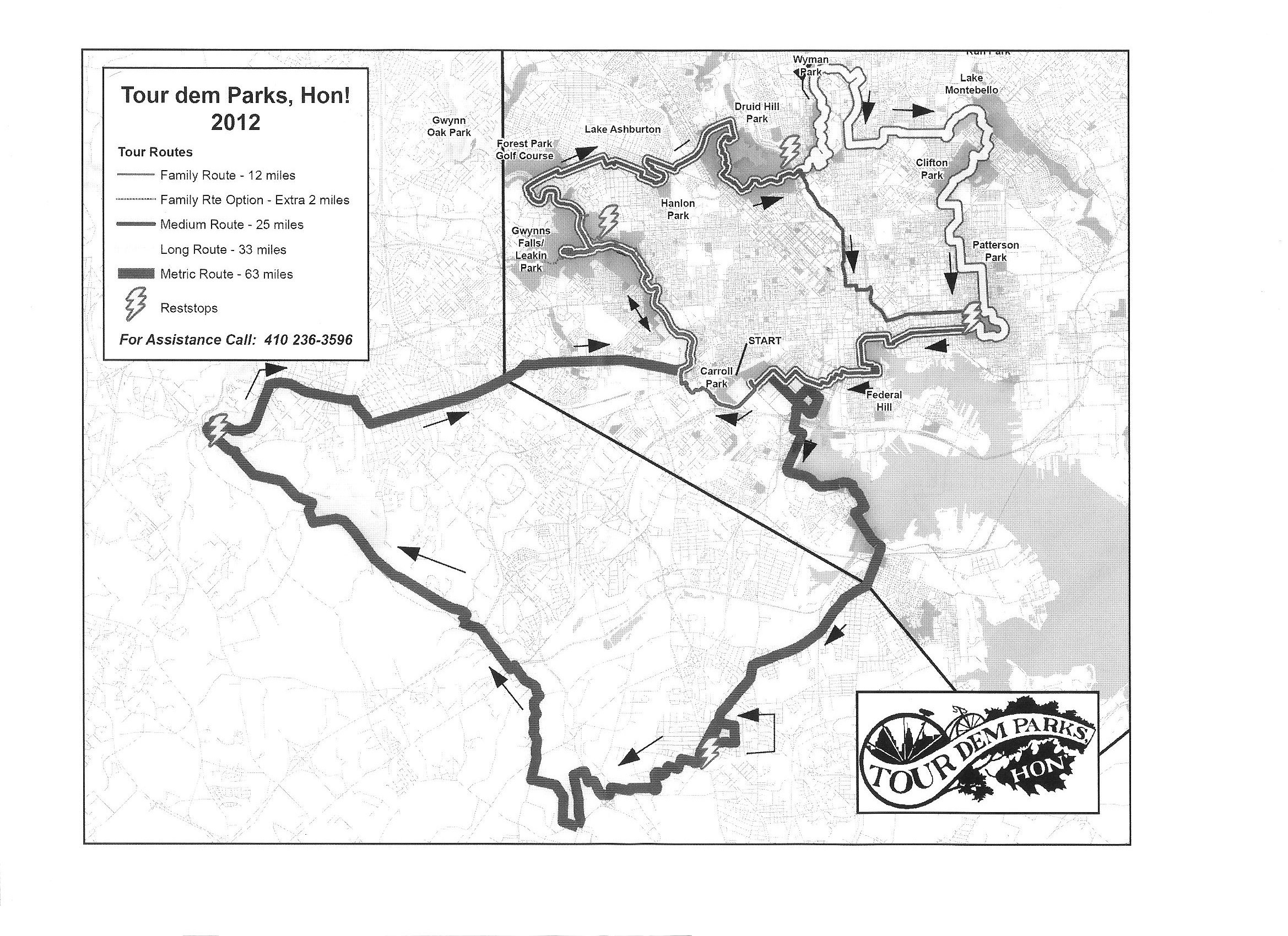
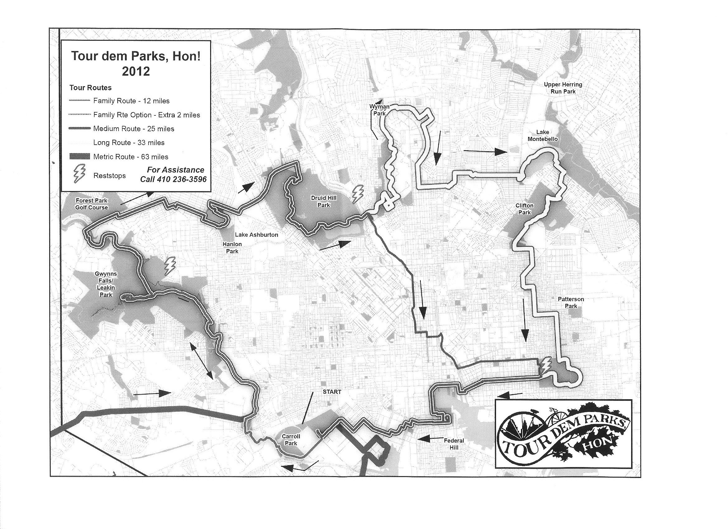
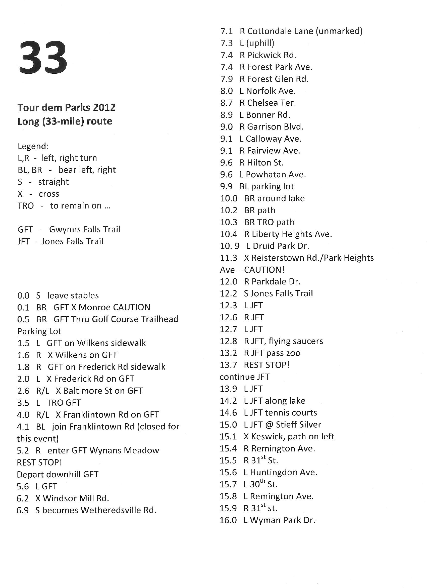
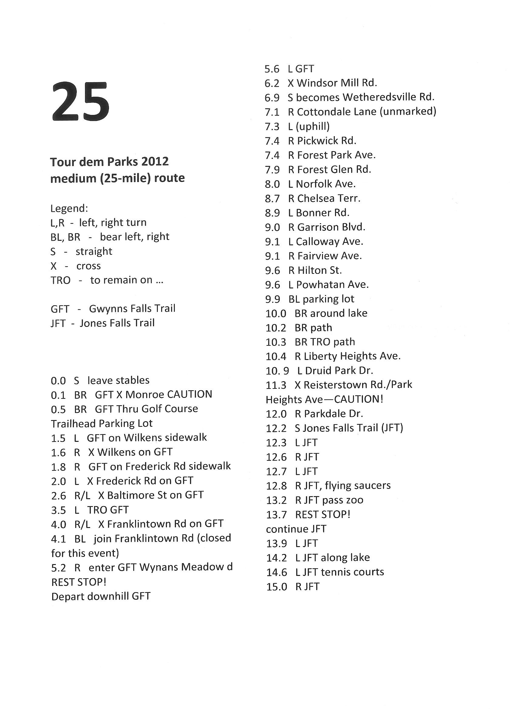
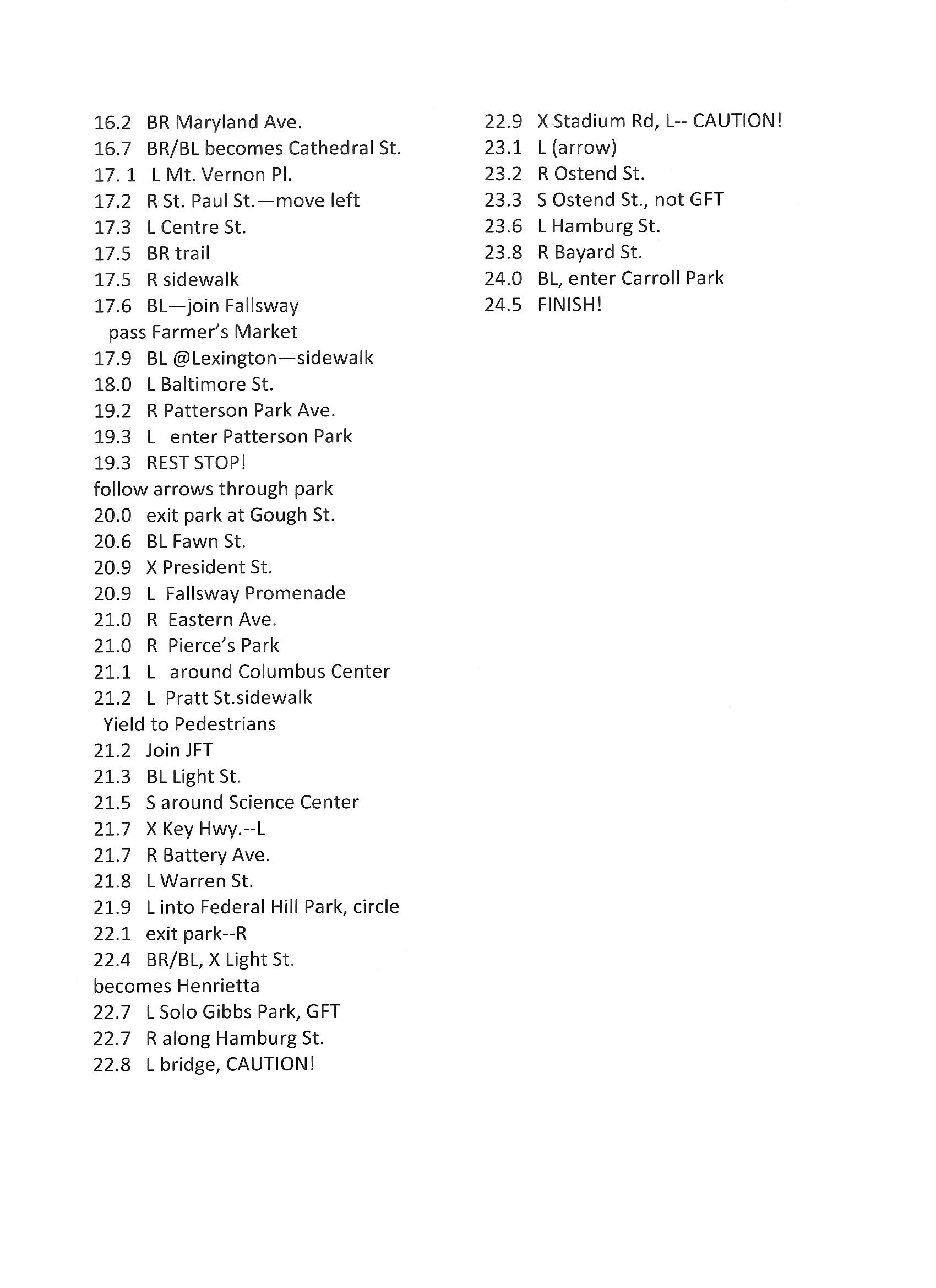
    LOCATION: In 2012, I did this organized ride which started and ended at Carroll Park, 1500 Washington Boulevard, Baltimore, Maryland 21230. Baltimore City and County ADC map 42 H2. See map.

    DATE LAST UPDATED: June 10, 2012

    NOTES: Here are the maps and cue sheets we were given for this ride.
  • Tour Dem Parks Hon 2012 map 1
  • Tour Dem Parks Hon 2012 map 2
  • 33.5 mile route: cue sheet 1, cue sheet 2
  • 24.5 mile route: cue sheet 1, cue sheet 2

  • BLOGS: June 10, 2012

    ADDITIONAL INFORMATION: Tour dem Parks, Hon! through Baltimore's parks and trails
    Close accordion icon

    Trolley Line #9

    ViewTrail 100Open accordion icon
    LOCATION: This trip is described as
    A 100-mile cycling route through Maryland's only seaside county, featuring great rural landscapes, curious and historic towns and villages, spectacular waterfronts, abundant travel amenities, and more nature than one could possibly imagine. The trip begins in Berlin, Maryland...

    Start and end at Main (route 818) and Broad Streets, Berlin, Maryland 21811. Worcester County ADC map 7 D11. See map.

    DATE LAST UPDATED: August 15, 2010

    NOTES: If you hate hills and traffic, then this is the route for you. It is pretty scenic. Much of the south section goes by corn fields. You'll get some odors from the chicken farms but out in the country on the Maryland eastern shore, that is hard to avoid. Some of the west side is through wooded terrain. The only bad traffic I encountered was briefly in Pocomoke City.

    I first learned about this route after picking up a lovely "ViewTrail 100 - Explore Maryland's Beach & Beyond by Bike" brochure. Not sure where I got it but you can request one from Maryland - Worcester County, Maryland.

    I am not aware of any public restrooms along the route. Your best bet is to just find a fast food restaurant in Berlin or Pocomoke City. Unfortunately, there aren't too many of these in Berlin but if you are starting here, it may not matter much. I recommend packing some hydration drink mix powders and refilling your water bottle in Pocomoke City. In Pocomoke City, I suggest taking a short detour to where Linden Avenue turns into Old Snow Hill Road (route 756) at Ocean Highway (route 13) at 38.075159, -75.558997. There are fast food restaurants here that wouldn't mind if you used their restroom if you bought yourself a little something to eat too.

    BLOGS: Challenge Weekend 2010

    ADDITIONAL INFORMATION: Map My Ride - ViewTrail 100
    Bivy - ViewTrail 100
    Close accordion icon

    Washington, Baltimore, and Annapolis (WB&A) TrailOpen accordion icon
    LOCATION: As of January 2023, the WB&A trail is comprised of two discontiguous sections. The Prince George's County part contains six completed miles. Neighboring Anne Arundel County has completed about three miles between Odenton and the Piney Orchard community. These sections are separated by the Patuxent River.

    NOTES: In June 2023, a $5 million bridge will be built over the Patuxent River to connect the [two parts of the] trail:
    The idea behind the WB&A Trail goes back nearly 30 years, and for more than a decade, parks and rec departments in Prince George's and Anne Arundel counties in Maryland have worked to make it a reality.
    The Patuxent River has been a sticking point since day one, but on Friday, local officials and advocates gathered to break ground on work to finally literally bridge that one dividing line.
    But within about a year, a $5 million bridge will help create a single, roughly 15-mile trail that also provides another crossing from Bowie to western Anne Arundel County.

    - from WTOP News - Final piece of Md. trail decades in the making finally coming together

    ADDITIONAL INFORMATION: Anne Arundel County - WB&A Trail
    Bike Washington - WB&A Trail

    The following sites are listed in order of north to south:

    Piney Orchard ParkwayOpen accordion icon
    LOCATION: This trailhead is on the east side of Piney Orchard Parkway, 170 feet north of Odenton Road, Odenton, Maryland 21113. Anne Arundel County ADC map 5171 H7. See map.

    DATE LAST UPDATED: April 30, 2018

    NOTES: This is the northern terminus of the northern section of the trail. There is no parking lot but one can park in the neighborhood.

    BLOGS: April 30, 2018
    Close accordion icon

    Patuxent RoadOpen accordion icon
    LOCATION: Parking and trailhead on the south side of Patuxent Road, just east of Bragers Road and one mile northwest of where it meets Conway Road, Odenton, Maryland 21113. Anne Arundel County ADC map 5291 E4. See map.

    DATE LAST UPDATED: April 30, 2018

    NOTES: Access to the northern section of the trail.

    BLOGS: April 30, 2018
    Close accordion icon

    Race Track RoadOpen accordion icon
    LOCATION: Park on the northeast side of Race Track Road, 240 feet southeast of where it meets Kimberwick Drive, Bowie, Maryland 20715. Prince George's County ADC map 5291 A9. See map.

    DATE LAST UPDATED: August 28, 2022

    NOTES: This is the northernmost lot in the southern section. From here, one can bike northeast for 0.38 miles to the Patuxent River or southwest for ~4.5 miles to the southern terminus.

    BLOGS: January 16, 2010 and August 28, 2022
    Close accordion icon

    GlenardenOpen accordion icon
    LOCATION: Park on the south side of Electric Avenue, 0.1 mile west of where it meets Glenn Dale Road (route 953), Glenarden, Maryland 20706. See Prince George's County ADC map 5411 K6. See map.

    DATE LAST UPDATED: August 28, 2022

    NOTES: This is the southernmost lot in the southern section. Parking for ~38 vehicles. Porta-john available.

    From here, one can bike southwest for 0.75 miles to the southern terminus at Annapolis Road (route 450).

    BLOGS: January 16, 2010 and August 28, 2022
    Close accordion icon
    Close accordion icon

    Western Maryland Rail TrailOpen accordion icon
    LOCATION: This rail trail parallels the Chesapeake and Ohio (C&O) Towpath and the Potomac River in Allegany County and Washington County, Maryland.

    PHONE: 301-842-2155

    DATE LAST UPDATED: Before 2010

    NOTES: This is a 28-mile paved trail. It is very scenic.

    ADDITIONAL INFORMATION: Maryland DNR - Western Maryland Rail Trail
    Bike Washington - Western Maryland Rail Trail
    AllTrails - Western Maryland Rail Trail
    Great Allegheny Passage - Western Maryland Rail Trail
    TrailLink - Western Maryland Rail Trail

    The following sites are listed in order of west to east:

    Little OrleansOpen accordion icon
    LOCATION: Parking and trailhead resides at 11741 High Germany Road, Little Orleans, Maryland 21766. Allegany County ADC map XX9. See map.

    NOTES: This site is near the western terminus of the trail.
    Close accordion icon

    Big PoolOpen accordion icon
    LOCATION: Parking and trailhead resides at the southwest side of Big Pool Road (route 56) where it meets Homestead Drive, Big Pool, Maryland 21711. Washington County ADC map 16 K8. See map.

    NOTES: This is the east terminus of the trail. Parking for 30+ vehicles.
    Close accordion icon
    Close accordion icon


    New Jersey


    Delaware and Raritan TrailOpen accordion icon
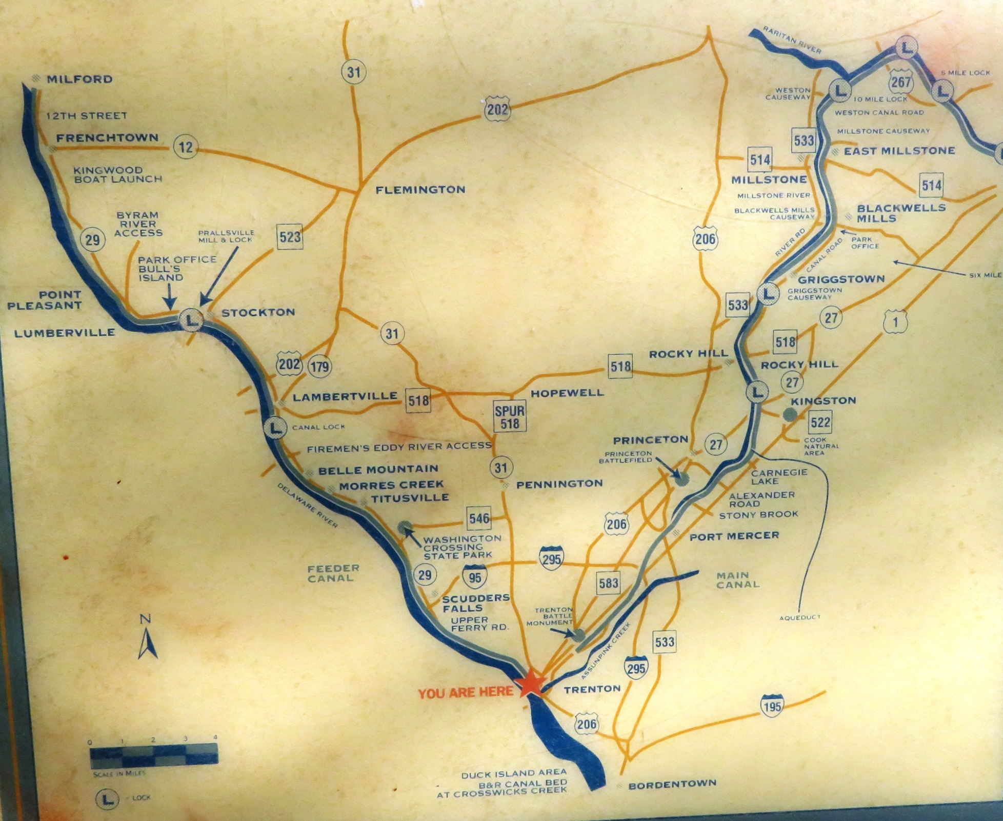
    LOCATION: This is a 69.5-mile long rail trail that runs largely along the Raritan Canal from Frenchtown, New Jersey to Trenton, New Jersey, and then to New Brunswick, New Jersey.

    DATE LAST UPDATED: April 16, 2017

    NOTES: This trail is sometimes referred to as the Delaware and Raritan Canal State Park Trail.

    From the New Brunswick terminus to the Delaware River in Trenton is about 31 miles. I don't believe there is camping anywhere near the trail here.

    What does this trail pass by?
  • Washington Crossing State Park: Camping is available here. See New Jersey Delorme map page 41 G23.
  • Bulls's Island Recreational Area: Camping not available. This place is near Raven Rock on the New Jersey Delorme map page 40 A12.
  • John W. Flemer Preserve: Has hiking trails.

  • BLOGS: April 15, 2017

    ADDITIONAL INFORMATION: Trail sign map - Trenton at south end
    Trail sign map - Delaware River
    TrailLink - Delaware and Raritan Canal State Park Trail
    TrailLink - Delaware and Raritan Canal State Park Trail - Itinerary
    New Jersey State Park Service - Delaware & Raritan Canal State Park
    #32 in The 50 Best Bike Trails in America - Delaware and Raritan Canal State Park
    D&R Canal Towpath Ride - A Tour Guide for Cyclists
    Wikipedia - Delaware and Raritan Canal
    HikingGuy - Delaware Canal State Park Towpath Hike

    The following sites are listed in order of west to east:

    MilfordOpen accordion icon
    LOCATION: This trailhead is accessible by some unnamed road on the southwest side of Frenchtown Road (route 619), 0.3 mile northwest of where Frenchtown Road intersects Kappus Road, Milford, New Jersey 08848. Follow this unnamed road to its southwest end. New Jersey Delorme map page 34 F10. See map.

    NOTES: This is the northwest terminus.
    Close accordion icon

    Calhoun Street BridgeOpen accordion icon
    LOCATION: This bridge crosses over the Delaware River, connecting Morrisville, Pennsylvania with Trenton, New Jersey. See map.

    NOTES: Much of the Delaware and Raritan Trail parallels the D&L and Delaware Canal Trail/Towpath on the Pennsylvania side of the Delaware River between Frenchtown, New Jersey, and Trenton, New Jersey. A good loop is to go up on one side and down on the other. This bridge is where one would cross between the two trails.
    Close accordion icon

    Lake CarnegieOpen accordion icon
    LOCATION: This trailhead and parking lot is just northwest of Mapleton Road, 0.15 mile southwest of where it meets Lakeview Terrace, Princeton, New Jersey 08540. See map.

    NOTES: If you want to bike this trail as part of an overnight trip, consider parking and accessing the trail here.
    Close accordion icon

    New BrunswickOpen accordion icon
    LOCATION: This trailhead is at Landing Lane Bridge where it crosses over the Raritan River in New Brunswick, New Jersey 08901. New Jersey Delorme map page 37 I19. See map.

    NOTES: This is the east terminus of the trail. There is some parking just north of the canal on the east side of Landing Lane Bridge, but there is significantly more south of the canal on the southeast side of where Landing Lane intersects George Street. One can also park at Johnson Park.
    Close accordion icon

    Johnson ParkOpen accordion icon
    LOCATION: There is a large parking lot in this park just northwest of where Violet Drive (route 807) and Johnson Drive intersect, Piscataway, New Jersey 08854. See map.

    NOTES: If you wanted to do this trail as part of an overnight trip, consider parking here to access the trail. Porta-johns present.

    The New Brunswick trailhead is south of Johnson Park, across the Raritan River.
    Close accordion icon
    Close accordion icon


    Pennsylvania


    Bristol Spurline Park Trail - Delaware Canal State ParkOpen accordion icon
    LOCATION: This is a 2.5-mile long rail trail.

    The south terminus is at Delaware Canal State Park, 150 Basin Street, Bristol, Pennsylvania 19007. This is where Mill Creek flows into the Delaware River, northwest of Burlington Island. New Jersey Delorme map page 47 F23. I'm sure you can find this on the Pennsylvania Delorme map too but I prefer to use the New Jersey one because this trail connects to a network of trails in New Jersey. See map.

    PHONE: 610-982-5560

    DATE LAST UPDATED: April 16, 2017

    NOTES: There is plenty of parking at the south terminus. This will put you within a mile of the south terminus of the D&L and Delaware Canal Trail/Towpath.

    BLOGS: April 16, 2017

    ADDITIONAL INFORMATION: TrailLink - Bristol Spurline Park
    Close accordion icon

    D&L and Delaware Canal Trail/TowpathOpen accordion icon
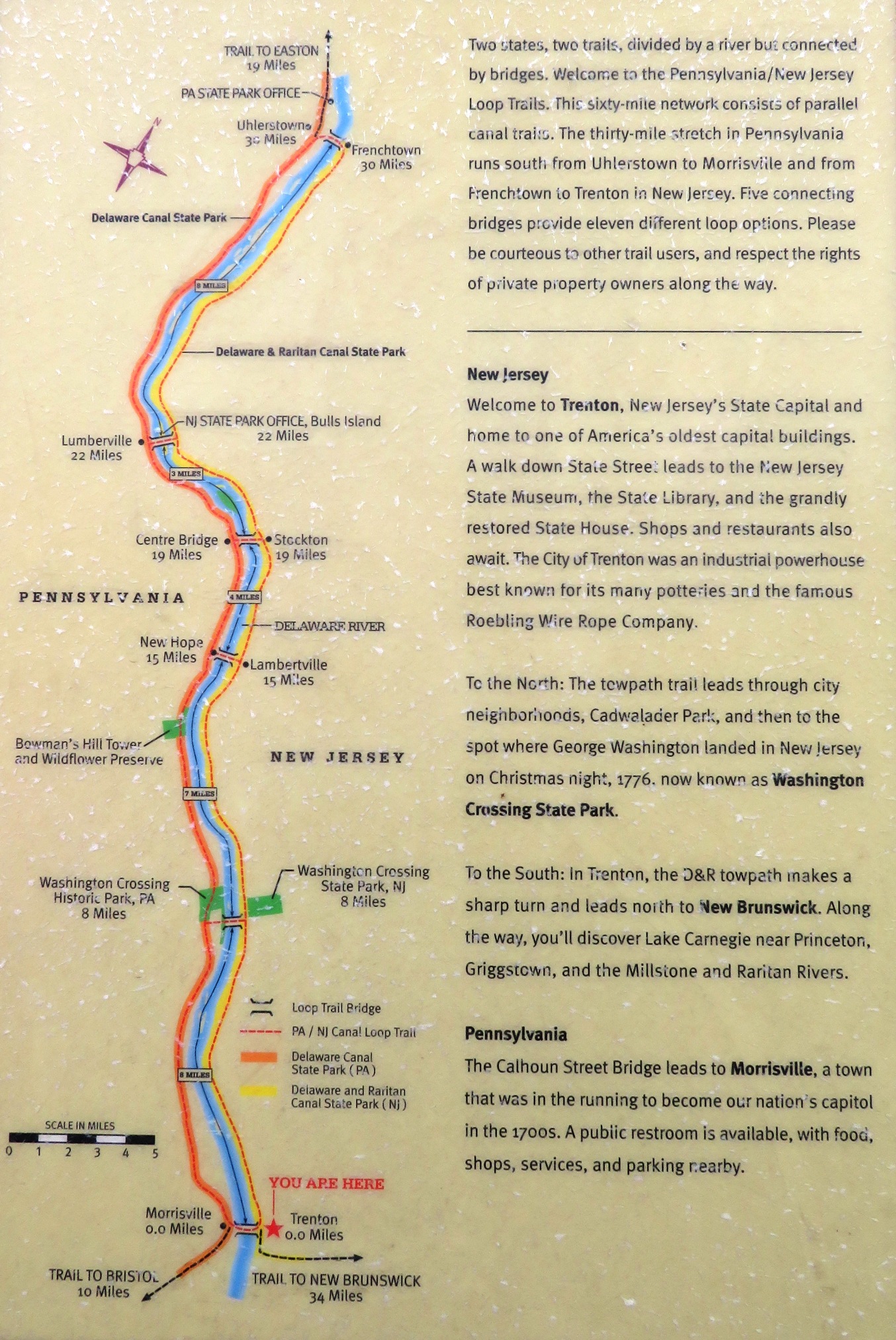
    LOCATION: The Delaware and Lehigh (D&L), Delaware Canal Trail, and Delaware Canal Towpath comprise a 60-mile trail that runs along the Delaware River from Easton, Pennsylvania to Bristol, Pennsylvania.

    DATE LAST UPDATED: April 16, 2017

    NOTES: At least some parts of this trail is comprised of rail trail and/or towpath.

    Much of the trail parallels the Delaware and Raritan trail on the New Jersey side of the Delaware River between Frenchtown, New Jersey and Trenton, New Jersey. A good loop is to go up on one side and down on the other. One can cross from one side to the other at the Calhoun Street Bridge.

    From Morrisville, Pennsylvania to the Easton terminus is 53 miles.

    What does this trail pass by?
  • Durham Aqueduct and Lock 21
  • Mariton Wildlife Sanctuary in Easton, Pennsylvania

  • BLOGS: April 16, 2017

    ADDITIONAL INFORMATION: Trail sign map - Trenton at south end
    Trail sign map - Delaware River
    Delaware & Lehigh - National Heritage Corridor
    Wikipedia - Pennsylvania Canal (Delaware Division)
    USA Today - Cycling Along the Delaware Canal
    TrailLink - D&L Trail, Delaware Canal Towpath

    The following sites are listed in order of north to south:

    North PointOpen accordion icon
    LOCATION: Trailhead and parking located at the south side of where the Lehigh River flows into the Delaware River, Easton, Pennsylvania 18042. New Jersey Delorme map page 28 M2. I'm sure you can find this on the Pennsylvania Delorme map too but I prefer to use the New Jersey one because this trail connects to a network of trails in New Jersey. See map.

    NOTES: This is the northernmost part of the trail.
    Close accordion icon

    Hugh Moore Park RoadOpen accordion icon
    LOCATION: Southwest of North Point is trail access just north of Hill Road at 2300 Hugh Moore Park Road, Easton, Pennsylvania 18042. New Jersey Delorme map page 28 M1. See map.
    Close accordion icon

    BristolOpen accordion icon
    LOCATION: The trailhead is on the northeast side of Washington Street, 140 feet northwest of Canal Street, Bristol, Pennsylvania 19007. New Jersey Delorme map page 47 23E. See map.

    NOTES: This is the southern terminus of the trail.

    One can bike southeast for not more than 500 feet on Washington Street or its northeast parallel neighbor, Jefferson Avenue, to connect to the Bristol Spurline Park Trail. Then bike southwest for a mile on this trail to Delaware Canal State Park, where there is plenty of parking.
    Close accordion icon
    Close accordion icon

    Enola Low Grade TrailOpen accordion icon
    LOCATION: Chester and Lancaster Counties, Pennsylvania.

    DATE LAST UPDATED: April 16, 2024

    NOTES: This is a ~29-mile crushed gravel rail trail.

    ADDITIONAL INFORMATION: TrailLink - Enola Low Grade Trail
    Susquehanna Greenway Partnership - Enola Low Grade Rail Trail
    AllTrails - Enola Low Grade Trail

    The following sites are listed in order of west to east:

    Turkey Hill Nature Preserve

    AtlgenOpen accordion icon
    LOCATION: This location is ~0.2 mile east of where the trail crosses Valley Road (route 372), Atglen, Chester County, Pennsylvania 19310. Some maps call this road Upper Valley Road. See map.

    NOTES: This is the eastern terminus of the trail. I don't know the best place to park nearby.
    Close accordion icon
    Close accordion icon

    Heritage Rail Trail County ParkOpen accordion icon
    LOCATION: This 27.4-mile rail trail in York County, Pennsylvania extends from the Mason-Dixon Line in the south to the John C. Rudy County Park in the north.

    The southernmost part of the trail ends in Maryland and continues as the Torrey C. Brown Rail Trail.

    PHONE: 717-840-7440

    DATE LAST UPDATED: Before 2010

    NOTES: This trail was previously known as the York County Heritage Trail. The northern sections tend to be more natural while the southern sections pass through small towns.

    BLOGS: November 17, 2007

    ADDITIONAL INFORMATION: York PA - Heritage Rail Trail County Park
    York County Rail Trail Authority - Heritage Rail Trail County Park
    TrailLink - Heritage Rail Trail County Park: Map shows places to park
    Bike Washington - The Northern Central & York County Heritage Trails
    York County Heritage Trail - Northern Section
    York County Heritage Trail - Southern Section

    The following sites are listed in order of south to north:

    FreelandOpen accordion icon
    LOCATION: 1.8 miles south of Heritage Rail Trail County Park. See Torrey C. Brown Rail Trail / NCR Trail - Freeland

    NOTES: This is the northernmost parking lot on the Torrey C. Brown Rail Trail.
    Close accordion icon

    Orwig RoadOpen accordion icon
    LOCATION: ~19.7 miles from the southernmost end of the Torrey C. Brown Rail Trail. York County, Pennsylvania ADC map 49 D13. See map.

    NOTES: This is the first stop in Pennsylvania, only about 450 feet north of the state line. Though there is no road sign at the trail, there will be a large sign which reads "Welcome to New Freedom." It is likely the names of places in this area (New Freedom and Freeland) were chosen because the border between Pennsylvania and Maryland is the Mason-Dixon Line, which separated the slave states from the free states. No parking.
    Close accordion icon

    New FreedomOpen accordion icon
    LOCATION: Located 1.5 miles from the southernmost part of the trail. York County, Pennsylvania ADC map 49 D6. See map.

    NOTES: There is parking throughout the area along with several restaurants. The train depot was restored to its 1940 appearance with a museum depicting railroad and local community history. Some sources say this is the highest point on the trail.
    Close accordion icon

    RailroadOpen accordion icon
    LOCATION: About three miles from the southernmost part of the trail. York County, Pennsylvania ADC map 49 D6. See map.

    NOTES: Parking for 24 vehicles.
    Close accordion icon

    Glen RockOpen accordion icon
    LOCATION: About 6.25 miles from the southernmost part of the trail. York County, Pennsylvania ADC map 38 J13. See map.

    NOTES: Parking and restaurants throughout the area.
    Close accordion icon

    Hanover JunctionOpen accordion icon
    LOCATION: This is about the midpoint of the trail. York County, Pennsylvania ADC map 38 C4. See map.

    NOTES: Parking for ~40 vehicles. Regular restrooms available. Picnic tables and a museum. Water refill station available. If it is working, be sure to refill here as the trail seems to be lacking in water fountains. About 11.5 miles north of the southern end of the trail and 9.6 miles south of the northern end.
    According to "Countryside America, Southern York County, Pennsylvania":
    The Hanover Jucntion train station offers and inside look at Civil War history. The first floor was restored to its 1863 appearance, when President Lincoln passed through on his way to Gettysburg.
    Close accordion icon

    Seven ValleysOpen accordion icon
    LOCATION: About 11 miles from the southernmost part of the trail. York County, Pennsylvania ADC map 38 D2. See map.

    NOTES: Two large bicycles and one tricycle sculture make this stop unmistakeable. Covered picnic tables. The lot holds about ~30 vehicles.
    Close accordion icon

    Brillhart StationOpen accordion icon
    LOCATION: This stop is 17 miles from the southernmost part of the trail. York County, Pennsylvania ADC map 29 F6. See map.

    NOTES: The lot holds ~40 vehicles. Consider a side trip to William H. Kain County Park which is only two miles away.
    Close accordion icon

    North Pershing AvenueOpen accordion icon
    LOCATION: North Pershing Avenue, 300 feet south of West Gay Avenue, York, Pennsylvania 17401. York County, Pennsylvania ADC map 21 J9. See map.

    NOTES: Some maps might lead one to think that the trail ends at this location but it does not.
    Close accordion icon

    Hamilton AvenueOpen accordion icon
    LOCATION: This site is at the north end of Hamilton Road, York, Pennsylvania 17401. York County, Pennsylvania ADC map 21 K7. See map.

    NOTES: From North Pershing Avenue, the trail continues north, but rather than following a route dedicated to non-motorized vehicles, it instead follows vehicular roads for a short distance to Hamilton Avenue.
    Close accordion icon

    Arsenal Road (route 30)Open accordion icon
    LOCATION: This stop is ~22.6 miles from the southernmost part of the trail. York County ADC map 21 K5. See map.

    NOTES: There are various places to access the trail in York City. This one supposedly has a restroom and parking for ~26.
    Close accordion icon

    John C. Rudy ParkOpen accordion icon
    LOCATION: This stop is 27.4 miles from the southernmost part of the trail. 400 Mundis Race Road, York, Pennsylvania 17402, York County ADC map 15 C12. See map.

    NOTES: This is the northernmost stop on the trail. There are more parking spaces than I could shake a stick at.
    Close accordion icon
    Close accordion icon

    Pine Creek Rail TrailOpen accordion icon
    LOCATION: The 62-mile long Pine Creek Rail Trail passes through the Grand Canyon of Pennsylvania in the north-central part of the state.

    NOTES: While the trail is spectacular, be sure to make time for exploring the multitude of neighboring trails if you can. In the springtime, consider kayaking, rafting, or tubing down the creek.

    I highly recommend sticking to the major roads when driving to your destination. Just because you see a road on your map doesn't mean it will easily take you where you want to go.

    The best part of the rail trail, in terms of scenery, is the Grand Canyon of Pennsylvania.

    The West Rim Trail is the much-talked-about backpacking trail in the area.

    One can find a nice day hike at Bee Tree Ski Trail if you can find the trails and are willing to do a little bushwhacking.

    BLOGS: February 15, 2009, July 3-5, 2009, October 10-12, 2009, and August 15, 2022

    ADDITIONAL INFORMATION: Launch Sites - Pine Creek Gorge
    PA Canyon - Pine Creek Rail Trail
    TrailLink - Pine Creek Rail Trail: Good source for trail access
    Visit Potter-Tioga - Pine Creek Gorge
    Pine Creek Outfitters: These guys rent bikes, can provide shuttle service, and have a lot of good information
    Pine Creek Valley - Pine Creek Rail Trail - Rail Trail Parking Areas: Good source for trail access
    Wikipedia - Pine Creek Rail Trail

    The following trail access points are listed from north to south:

    Butler Access Area / Wellsboro JunctionOpen accordion icon
    LOCATION: This trailhead is on the west side of Butler Road, 450 feet north of where it intersects with route 287, Wellsboro, Pennsylvania 16901. See map.

    DATE LAST UPDATED: October 10-12, 2009

    BLOGS: October 11, 2009

    NOTES: This is the north terminus of the trail. You'll find parking for ~17 vehicles. Pine Creek flows downstream from this area because it is the highest point on the water. Thus, if you plan on biking the entire trail, it is recommended to start at this end for an easier ride.
    Close accordion icon

    Marsh CreekOpen accordion icon
    LOCATION: Trailhead and parking is on the east side of Marsh Creek Road (route 3027), 200 feet south of where it meets Confer Lane, Wellsboro, Pennsylvania 16901. This is just west of Marsh Creek. See map.

    DATE LAST UPDATED: August 15, 2022

    NOTES: This is a great place to access the most scenic part of the rail trail. You'll have really nice views of Pine Creek.

    This location is very close to Pine Creek Outfitters. If you rent a bike from them, they might shuttle you here for an out-and-back trip.

    BLOGS: August 15, 2022
    Close accordion icon

    Big Meadows Canoe Access Area - Ansonia

    Robert McCullough Jr. Pine Creek Access - Blackwell

    Ramsey VillageOpen accordion icon
    LOCATION: Trailhead and limited parking at the intersection of Ramsey Drive and Route 44 in Jersey Shore, Pennsylvania 17740. See map.

    DATE LAST UPDATED: October 10-12, 2009

    NOTES: There is room for ~four vehicles.
    Close accordion icon

    South TerminusOpen accordion icon
    LOCATION: The trailhead is at the northwest end of Seminary Street, Jersey Shore, Pennsylvania 17740. See map.

    The best place to park near here is 0.9 mile away via trail on the south side of the intersection of Railroad Street and Humes Street, Jersey Shore, Pennsylvania 17740. See map.

    DATE LAST UPDATED: October 10-12, 2009

    NOTES: This is the south terminus of the trail.
    Close accordion icon
    Close accordion icon

    Three Rivers Heritage TrailOpen accordion icon
    LOCATION: This trail runs along parts of the Ohio River, Monongahela River, and Allegheny River in Pittsburgh and Allegheny County, Pennsylvania.

    DATE LAST UPDATED: Unexplored

    NOTES: This is a 33-mile trail. It overlaps slightly with the Great Allegheny Passage at Point State Park.

    ADDITIONAL INFORMATION: Friends of the Riverfront - Three Rivers Heritage Trail
    American Trails - Three Rivers Heritage Trail, Pennsylvania
    TrailLink - Three Rivers Heritage Trail
    Close accordion icon


    Virginia


    Eastern Shore of Virginia (ESVA) Rail TrailOpen accordion icon
    LOCATION: Eastern shore of Virginia.

    NOTES: As of 2024,
    The future ESVA Rail Trail will be a 49-mile walking and biking trail along the historic Eastern Shore railroad corridor. For the safety of all, the rail corridor is not yet open to the public. Instead, pay a visit to the Southern Tip Bike and Hike Trail.
    - from Eastern Shore of Virginia Rail Trail

    The following trail access points are listed from north to south:

    Southern Tip Bike and Hike TrailOpen accordion icon
    LOCATION: Park at the Eastern Shore of Virginia National Wildlife Refuge - Butterfly Trail / Visitor Center. See map.

    NOTES: There is a restroom at the Visitor Center. At the trailhead, there is an area with some bicycle tools and a pump.

    This 2.6-mile paved trail begins at the Eastern Shore of Virginia National Wildlife Refuge Visitor Center and runs parallel to U.S. Highway 13 through shrub/scrub habitat, agricultural fields, and mixed hardwood groves. During fall migration, delight in the variety of birds that stop over on their journey south. Enjoy wildlife observation, photography, biking, and hiking year-round.
    - from sign at trailhead titled "Eastern Shore of Virginia National Wildlife Refuge"

    As of 2024, the trail is supposedly at least five miles one way.

    BLOGS: April 20, 2024

    ADDITIONAL INFORMATION: AllTrails - Southern Tip Bike and Hike Trail
    Close accordion icon
    Close accordion icon

    Mount Vernon TrailOpen accordion icon
    LOCATION: The Mount Vernon Trail was created in 1973 by the National Park Service. Its 18.5 miles passes along the Potomac River, next to the George Washington Memorial Parkway. The trail goes from Mount Vernon, the home of George Washington, to Theodore Roosevelt Island in the Potomac River near the Lincoln Memorial. It is a paved trail that is excellent for joggers, bicyclists, skaters, or walkers who want a scenic view of the nation's capitol and the Potomac River.

    PHONE: 703-289-2500

    DATE LAST UPDATED: March 21, 2023

    NOTES: This is a very popular trail that gets a lot of use.

    ADDITIONAL INFORMATION: NPS - Mount Vernon Trail
    TrailLink - Mount Vernon Trail
    Bike Washington - The Mount Vernon Trail
    AllTrails - Mount Vernon Trail
    The Mount Vernon Trail - Connector to American History

    The following trail access points are listed from north to south:

    Theodore Roosevelt IslandOpen accordion icon
    LOCATION: Theodore Roosevelt Island is in Washington, D.C.

    The trail and parking lot is located on the east side of the George Washington Memorial Parkway and west of the Potomac River, Arlington County, Virginia. It is ~0.5 mile north of Curtis Memorial Parkway (route 66) and just west of the island. It can only be accessed from George Washington Memorial Parkway northbound. A pedestrian bridge provides easy access from the lot to the island. Metro Washington, D.C. ADC map 15 E1. See map.

    NOTES: It can be tough to find parking here on a nice weekend or holiday so if that is your goal, I suggest you start very early or have a back-up plan.

    Since the Potomac River flows from north to south in Washington, D.C., one might think this end of the trail is much higher than the south trailhead. But I have found nothing to confirm this and if there is any difference, I expect it is negligible.

    Porta-john available in the parking lot and on the island.

    You can rent bikes here.

    This spot is 17.5 miles from the south terminus of the trail.

    BLOGS: June 11, 2006 and April 14, 2013

    ADDITIONAL INFORMATION: NPS - Theodore Roosevelt Island
    National Park Planner - Theodore Roosevelt Island
    Close accordion icon

    Lady Bird Johnson Park / Columbia Island Marina

    Gravelly Point

    Daingerfield Island

    Jones Point ParkOpen accordion icon
    LOCATION: Parking at the east end of Jones Point Drive, Alexandria, Virginia 22314. Metro Washington, D.C. ADC map 21 J7. See map.

    NOTES: There is a ~0.7 mile interpretive trail. At the south end of the park is the 1855 Jones Point Lighthouse. Lots of parking and a restroom under highway 495. This park is 9.3 miles from the south terminus and close to the trail midpoint.

    ADDITIONAL INFORMATION: NPS - Jones Point Park
    NPS - Jones Point Lighthouse
    AllTrails - Jones Point Lighthouse
    Close accordion icon

    Belle Haven

    Fort Hunt ParkOpen accordion icon
    LOCATION: The closest parking lot to the trail is on the south side of Fort Hunt Park Loop, Alexandria, Virginia 22308. If north on the loop is 12 o'clock, then the lot is as 1:30. Northern Virginia Area ADC map 30 G8. See map.

    PHONE: 202-439-7325

    NOTES: This place has some old military ruins from when the fort defended the Potomac River during the Spanish American War. It is 3.3 miles from the south terminus.

    Restrooms available.

    ADDITIONAL INFORMATION: NPS - Fort Hunt Park
    NPS - Fort Hunt Park Map
    AllTrails - Fort Hunt Park Main Loop
    Close accordion icon

    Mount VernonOpen accordion icon
    LOCATION: The parking lot that provides best access to the trail is on the east side of George Washington Memorial Parkway just before the circle where it ends, Mount Vernon, Virginia 22121. Northern Virginia Area ADC map 30 B9. See map.

    PHONE: 703-780-2000

    NOTES: There are various tours one can take for a fee but parking is free and there is a lot of it. Restrooms are to the south, by the shops.

    ADDITIONAL INFORMATION: NPS - Mount Vernon, Virginia
    NPS - George Washington's Mount Vernon and Estates
    George Washington's Mount Vernon
    Close accordion icon
    Close accordion icon

    Virginia Creeper TrailOpen accordion icon
    LOCATION: The Virginia Creeper Trail connects Abingdon, Virginia with the Virginia / North Carolina border.

    PHONE: Mount Rogers National Recreation Area: 276-783-5196 or 800-628-7202

    DATE LAST UPDATED: Unexplored

    NOTES: This 33.2-mile long rail trail is shared with equestrians. The nickname "Virginia Creeper" came from the early steam locomotives as they slowly struggled up the mountains.

    In 2014, this trail was inducted in to the Rail-to-Trail Hall of Fame.

    ADDITIONAL INFORMATION: Virginia Creeper Trail
    TrailLink - Virginia Creeper National Recreation Trail
    U.S. Department of Agriculture - Forest Service - Virginia Creeper Trail

    The following trail access points are listed from west to east:

    WhitetopOpen accordion icon
    LOCATION: Northeast side of Whitetop Gap Road, Whitetop, Virginia 24292. This is 0.1 mile southeast of the Whitetop Station Visitor Center (aka White Top Depot). See map.

    NOTES: The Whitetop Station Visitor Center lies 1.1 miles from the Virginia / North Carolina border. This is the highest point on the trail. Parking for 15+ vehicles. On nice days, the lot may fill up quickly. Water and restrooms at the Whitetop Station Visitor Center.

    ADDITIONAL INFORMATION: Virginia Creeper Trail - Whitetop Station
    Close accordion icon

    DamascusOpen accordion icon
    LOCATION: The Damascus Town Park is located near 202 South Beaver Dam Avenue, Damascus, Virginia 24236, on the east side of South Beaver Dam Avenue and just south of West Laurel Avenue (route 58). See map.

    NOTES: The town of Damascus lies 17.9 miles from the Virginia / North Carolina border and 15.5 miles from Abingdon. Here, you'll find lots of parking and a restroom. Nearby are dining and lodging options. The town claims to be the "friendliest town on the trail" and is a place where numerous trails and routes converge.

    ADDITIONAL INFORMATION: Visit Damascus, Virginia
    Close accordion icon

    AbingdonOpen accordion icon
    LOCATION: The Welcome Center is located at 300 Green Spring Road, Abingdon, Virginia 24210 on the southeast side of the intersection of Green Spring Road and A Street Southeast. See map.

    NOTES: Directly across Green Spring Road (west side) is parking for 30+ vehicles. The Abingdon trailhead and west trail terminus are on the east side of Green Spring Road, directly across from the south side of the parking lot and south of the Welcome Center. This location lies 33.4 miles from the Virginia / North Carolina border.

    The Virginia Creeper Trail Bike Shop resides two blocks north of the trailhead and provides bike rental and shuttle service.

    There are numerous options for lodging and dining in Abingdon.

    ADDITIONAL INFORMATION: Abingdon, Virginia - The Virginia Creeper Trail
    Close accordion icon
    Close accordion icon


    Washington, District of Columbia (D.C.) Metropolitan Area


    Anacostia Tributary Trail SystemOpen accordion icon
    LOCATION: The Anacostia Tributary Trail System, a link in the national shore-to-shore American Discovery Trail, provides miles of uninterrupted trails along the tributaries of the Anacostia River. The southernmost point of the trail is located at Colmar Manor Community Park, and trail spurs extend northeasterly and northwesterly from there along beautiful stream valley parkland. The trail system's continuous greenway traverses a variety of natural environments including woodlands, open fields, and wetlands.
    - from Experience Prince George's County - Anacostia Tributary Trail System

    PHONE: 301-699-2255

    DATE LAST UPDATED: Unexplored

    NOTES: How many miles of trails are in the system?
    M-NCPPC and Prince George's County Department of Parks and Recreation connected and upgraded the stream valley trails into a consistent network of approximately 24 miles (39 km) of paved 6–10-foot-wide (1.8–3.0 m) off-road paths.
    - from Wikipedia - Anacostia Tributary Trail System

    As of 2023, the system is comprised of the following trails:
  • Anacostia Riverwalk Trail: 7.9 miles
  • Benning Road to Bladensburg: 3.96 miles
  • Indian Creek Trail: 5.94 miles
  • Lake Artemesia: 1.34 miles
  • Northwest Branch Trail: 5.20 miles
  • NW Branch Trail: 2.25 miles. Despite the name similarity, this is different from "Northwest Branch Trail."
  • Paint Branch Trail: 3.29 miles
  • Rachel Carson Greenway Trail: 1.19 miles
  • Sligo Creek Trail: 8.71 miles
  • Watts Branch - Lower: 0.57 miles
  • Watts Branch Trail: 1.19 miles
  • Wheaton Regional Park: 2.20 miles

  • ADDITIONAL INFORMATION: Anacostia Tributary Trail System
    TrailLink - Anacostia Tributary Trail System: Map shows public parking access
    Bike Washington - The Anacostia Tributary Trails
    Birder's Guide to Maryland & DC - Bladensburg Waterfront Park, Colmar Manor Community Park & Anacostia River Trail

    Various sources break the system down into smaller pieces. The structure I use is based on Wikipedia - Anacostia Tributary Trail System.

    Northwest Branch TrailOpen accordion icon

    Northeast Branch TrailOpen accordion icon

    Anacostia River TrailOpen accordion icon
    NOTES: This passes through the following locations, all of which have ample free parking and restrooms.
  • Colmar Manor Community Park
  • Bladensburg Waterfront Park
  • Kenilworth Aquatic Gardens
  • Anacostia Park

  • It also connects with the Rachel Carson Greenway and Northwest Branch Stream Valley Park - Burnt Mills East.

    PHONE: 301-627-7755

    ADDITIONAL INFORMATION: MNCPPC - Anacostia River Trail System
    TrailLink - Anacostia River Trail: Map shows public parking access
    Close accordion icon
    Close accordion icon

    Capital Crescent TrailOpen accordion icon
    LOCATION: The Capital Crescent Trail is an 11 mile rail-trail path that goes from Georgetown in Washington, D.C. to Bethesda, Maryland. It then continues to Silver Spring, Maryland as the Georgetown Branch Trail extension.

    DATE LAST UPDATED: Unexplored

    NOTES: The southern seven miles between Georgetown and Bethesda has a nine-foot wide asphalt surface and is in excellent condition. The northern Georgetown Branch Trail extension provides a crushed gravel surface for the last four miles between Bethesda and Silver Spring. The two parts are connected by a tunnel located under downtown Bethesda.

    The Chesapeake and Ohio (C&O) Towpath closely parallels the Capital Crescent Trail for a few miles. They meet at Fletcher's Boathouse.

    ADDITIONAL INFORMATION: Bike Washington - Capital Crescent Trail
    Coalition for the Capital Crescent Trail
    TrailLink - Capital Crescent Trail: Map shows places to park

    The following trail access points are listed from south to north:

    K Street NW and 31st Street NWOpen accordion icon
    LOCATION: The trailhead is just south of the intersection of K Street Northwest and 31st Street Northwest, Washington, D.C. 20007. Metro Washington, D.C. ADC map 9 F13. See map.

    NOTES: This is the southern terminus of the trail. Best to explore your parking options before you arrive.
    Close accordion icon

    BethesdaOpen accordion icon
    LOCATION: The trailhead is on the south side of Bethesda Avenue, 110 feet west of where it meets Woodmont Avenue, Bethesda, Maryland 20814. Montgomery County ADC map 36 A12. See map.

    NOTES: This is the northern terminus of the trail.
    Close accordion icon

    Georgetown Branch TrailOpen accordion icon
    LOCATION: The trailhead is on the south side of Stewart Avenue, 230 feet southeast of Brookville Road, Silver Spring, Maryland 20910. Montgomery County ADC map 36 G8. See map.

    NOTES: From Bethesda, the trail continues northeast as the Georgetown Branch Trail. This location is the northeastern terminus of that trail.
    Close accordion icon
    Close accordion icon

    Georgetown Branch Trail

    Mount Vernon Trail


    West Virginia

    For an overview of West Virginia biking routes, see
  • West Virginia Rails-to-Trails Council

  • Marion County Trail (MCTrail)Open accordion icon
    LOCATION: Along Pricketts Creek in Marion County, West Virginia.

    PHONE: 304-363-7037

    DATE LAST UPDATED: July 2, 2011

    NOTES: This is a 2.5-mile rail trail which connects to a network of other trails in West Virginia.

    BLOGS: July 2, 2011

    ADDITIONAL INFORMATION: West Virginia Rails-to-Trails Council - Marion County Trail (MCTrail)
    Marion County Parks & Recreation - Rail Trails in Marion County
    TrailLink - Marion County Trail (MCTrail)

    The following trail access points are listed from north to south:

    Prickett's Fort State ParkOpen accordion icon
    LOCATION: Trailhead and parking at Prickett's Fort State Park, 88 State Park Road, Fairmont, West Virginia 26554. See map.

    NOTES: This is the north terminus of the trail. Restroom available.

    This location is also a good place to access the south end of the Mon River Trail.
    Close accordion icon

    Winfield StreetOpen accordion icon
    LOCATION: Trailhead and parking on the north side of Winfield Street, 100 feet west of where it meets Black Avenue, Fairmont, West Virginia 26554. See map.

    NOTES: This is the south terminus of the trail. No restroom.
    Close accordion icon
    Close accordion icon

    Mon River Trail and Caperton TrailOpen accordion icon
    LOCATION: These trails run along the east side of the Monongahela River with the northern side ending at the Pennsylvania / West Virginia border.

    At the southern end, one can access the north side of the Marion County Trail (MCTrail).

    DATE LAST UPDATED: Unexplored

    NOTES: I don't quite understand why, but the Mon River Trail is divided into a north and south section that are discontiguous. They are linked by the Caperton Trail. Together, these trails are ~29 miles long.

    ADDITIONAL INFORMATION: Mon River Trails Conservancy
    TrailLink - Mon River Trail
    West Virginia Rail Trails - Caperton Rail Trail
    TrailLink - Caperton Trail
    Close accordion icon

    West Fork Rail Trail / Ralph S. Larue TrailOpen accordion icon
    LOCATION: This 14.5-mile trail lies in Harrison County and Marion County in West Virginia.

    DATE LAST UPDATED: July 2, 2011

    NOTES: This trail follows the southeastern side of the West Fork River.

    BLOGS: July 2, 2011

    ADDITIONAL INFORMATION: Marion County, West Virginia - West Fork River / Ralph S. Larue Rail Trail
    National Recreation Trail (NRT) Database - Ralph S. Larue / West Fork Trail
    TrailLink - West Fork River Trail

    The following trail access points are listed from north to south:

    Mary Lou Retton ParkOpen accordion icon
    LOCATION: The Mary Lou Retton Park Trailhead resides at 337 Norway Road, Fairmont, West Virginia 26554. See map.

    Park at the Mary Lou Retton Youth Park. This resides at 1000 Cole Street, Suite B, Pleasant Valley, West Virginia 26554. See map. This location is 0.8 mile south of the Mary Lou Retton Park Trailhead.

    NOTES: The trailhead is 0.7-mile west of the trail's northeastern terminus.
    Close accordion icon

    ShinnstonOpen accordion icon
    LOCATION: The trailhead is on the northwestern side of South Pike Street (route 19), 200 feet southwest of where it meets Lynn Street, Shinnston, West Virginia 26431. See map.

    NOTES: This is the southwestern terminus of the trail.
    Close accordion icon
    Close accordion icon


    Multi-State Routes


    Chesapeake and Delaware (C&D) Canal, Michael N. Castle Trail, and Ben Cardin Recreational TrailOpen accordion icon
    LOCATION: This trail runs alongside the Chesapeake and Delaware (C&D) Canal from Chesapeake City, Maryland to Delaware City, Delaware. It connects the Chesapeake Bay with the Delaware River passing through Cecil County, Maryland and New Castle County, Delaware.

    DATE LAST UPDATED: June 13, 2020

    NOTES: The Ben Cardin Recreational Trail is 1.8-miles long and is the Maryland portion of this trail system. The Michael N. Castle Trail is the 12.4-mile long section of the canal trail located in the State of Delaware. The east end of the Michael Castle Trail meets up with the trails in Delaware City that continue for another 0.6-miles along the canal and reach to Fort Delaware State Park on the Delaware River.
    - from "Walk Ride USA - Michael Castle Trail & Ben Cardin Recreational Trail, C&D Canal, Delaware"

    Open sunrise to sunset. No horses or motorized vehicles.

    BLOGS: June 13, 2020

    ADDITIONAL INFORMATION: Chesapeake Living - C&D Canal Bike Trail: What You Need to Know on the Scenic Waterfront Ride
    Delaware Greenways - Michael N. Castle C & D Canal Trail
    Ride with GPS - C&D Canal Ride Route - Chesapeake City (MD) to Delaware City (DE)
    MidAtlantic Day Trips - Enjoy a Perfect Bike Ride along the C&D Canal Trail

    The following trail access points are listed from east to west:

    Delaware CityOpen accordion icon
    LOCATION: The trailhead is on the southwest side of 5th Street (route 9), 400 feet northwest of Canal Street, Delaware City, Delaware 19706. New Castle County, Delaware ADC map 19 K2. See map.

    NOTES: This is the northeastern terminus of the Michael N. Castle Trail. From this location, one can follow Canal Street north and then continue on Clinton Street to for a total of 0.6 mile to Battery Park, where there are many things to do and see.

    There is a significant amount of parking at 39.579761, -75.588962, which is on the west side of where Washington Street and Harbor Street meet. This is 0.8 mile from the trailhead and 0.1 mile from Battery Park.

    Public restroom in Battery Park at 39.578521614060975, -75.58736625286492.

    Close accordion icon

    Chesapeake CityOpen accordion icon
    LOCATION: Trailhead at the south end of Lock Street, Chesapeake City, Maryland 21915. Cecil County, Maryland ADC map 18 E10. See map.

    NOTES: This is the western terminus of the Ben Cardin Recreational Trail. I don't believe there is a public restroom here.
    Close accordion icon
    Close accordion icon

    Chesapeake and Ohio (C&O) TowpathOpen accordion icon
    LOCATION: The Chesapeake and Ohio (C&O) canal follows the Potomac River for 184.5 miles from Washington D.C. to Cumberland, Maryland.

    PHONE: 301-739-4200

    DATE LAST UPDATED: October 12, 2015

    NOTES: The canal served as a transportation route from 1828-1924. Many original structures, including locks, lockhouses, and aqueducts, remain standing. The canal's towpath provides a nearly level, unbroken trail through the natural scenery of the Potomac River Valley. The towpath also makes for an easy hike or run.

    There are plenty of potholes so I don't recommend it for delicate road bikes.

    This is a great place for bicycle camping.

    BLOGS: October 9-12, 2015

    ADDITIONAL INFORMATION: Bike Washington - C&O Canal Bicycling Guide
    National Park Service - Chesapeake and Ohio Canal
    Fred - Chesapeake and Ohio Canal
    C&O Canal Association - Access Points: This is the source I use for the mileage shown below. The lowest miles are closest to Washington, D.C. and the highest are closest to Cumberland, Maryland. I have things sorted based on mileage.

    Fletcher's Boathouse (Mile 3.1)

    Carderock / Billy Goat Trail, Sections B & C (~Mile 10.5)Open accordion icon
    LOCATION: Carderock exit from the Clara Barton Parkway Potomac, Maryland 20854. Montgomery County ADC map 34 E13. See map.

    DATE LAST UPDATED: Before 2010

    NOTES: Restrooms available. This area is popular with rock climbers. Head east 0.6 mile on the towpath to access the east end of section C of the Billy Goat Trail. Montgomery County ADC map 34 E13. See map.

    Head west 0.6 mile to access the west end of section C of the Billy Goat Trail. Montgomery County ADC map 34 D13. See map.

    Walk west 0.9 mile from Carderock to catch the east end of the section B of the Billy Goat Trail. Montgomery County ADC map 34 E13. See map.

    BLOGS: April 29, 2006, January 5, 2008

    ADDITIONAL INFORMATION: National Park Service - Carderock Picnic Pavilion
    C&O Canal Trust - Carderock Picnic Pavilion
    Close accordion icon

    Anglers Inn / Billy Goat Trail, Sections A & B (Mile 12.2)Open accordion icon
    LOCATION: 10790 Macarthur Boulevard (south side), across from Old Angler Inn, Potomac, Maryland 20854. Montgomery County ADC map 34 A12. See map.

    DATE LAST UPDATED: February 1, 2022

    NOTES: This places fills up extremely fast. Arrive very early or very late. If you hate crowds, then avoid this place. Port-a-johns available. No fee.

    About a half mile northwest of Anglers Inn on the towpath is the southeast terminus of section A of the Billy Goat Trail. Montgomery County ADC map 33 K12. See map. This is the most rugged part of the trail and one of my personal favorites. Very rocky but only 1.7 miles long.

    About a 0.2 mile south of Anglers Inn on the towpath is the northwest terminus of section B of the Billy Goat Trail. Montgomery County ADC map 34 A12. See map. This is an easier section about 1.4 miles long.

    BLOGS: April 29, 2006, January 5, 2008

    ADDITIONAL INFORMATION: Launch sites - Angler's Canoe Launch
    Winter Hiking the Billy Goat Trail
    C&O Canal Trust - Anglers Inn
    National Park Planner - Billy Goat B
    AllTrails - Great Falls Overlook via Billy Goat Trail Section A
    Close accordion icon

    Great Falls Tavern Visitor Center / Billy Goat Trail, Section A (Mile 14.3)Open accordion icon
    LOCATION: See Launch sites - Great Falls Visitor Center

    PHONE: 301-767-3714

    DATE LAST UPDATED: February 1, 2022

    NOTES: Great Falls is a spectacular, rocky area along a white water rapids section of the Potomac River. It is popular with hikers, rock climbers, and white water kayakers. There is a section in Maryland and another in Virginia. This is about the former, since I am writing primarily about the C&O Towpath.

    Pay to enter. Restrooms, historic buildings, tours, snack stand, and a shop available, depending on the season.

    About 0.3 mile south on the towpath is a short trail/boardwalk that connects to Great Falls / Olmsted Island Overlook, a scenic waterfall view of the Potomac River. Definitely worth seeing.

    About 0.5 mile south of the visitor center is the northwest terminus of section A of the Billy Goat Trail. Montgomery County ADC map 33 H10. See map. This is the most rugged part of the trail. Very rocky but only 1.7 miles long.

    There are a significant number of wooded trails east of the Billy Goat Trail and the C&O towpath.

    To avoid the entrance fee, access via Anglers Inn or Carderock.

    If you hate crowds, avoid this place on weekends and holidays.

    BLOGS: April 29, 2006, January 5, 2008, June 18, 2011, May 31, 2020, and June 28, 2020

    ADDITIONAL INFORMATION: Winter Hiking the Billy Goat Trail
    National Park Service - Great Falls Tavern Visitor Center
    National Park Planner - Great Falls Tavern Visitor Center
    AllTrails - Great Falls Overlook via Billy Goat Trail Section A
    Close accordion icon

    Violettes Lock (Mile 22.1)

    Seneca Landing Park (Mile 22.8)

    Edwards Ferry (Mile 30.8)

    Monocacy Aqueduct / Mouth (Mile 42.1)

    Nolands Ferry (Mile 44.6)

    Point of Rocks (Mile 48.2)

    Lock 29 - Lander (Mile 50.8)

    Brunswick Bridge (Mile 55)

    Canal Road (~Mile 69.5)

    Big Slackwater (Mile 85.4)

    River Bottom Park / Williamsport (Mile 99.5)

    Cushwa Basin / Williamsport Visitor Center (Mile 99.6)Open accordion icon
    LOCATION: 205 West Potomac Street, Williamsport, Maryland 21795. Washington County ADC map 19 H13. See map.

    DATE LAST UPDATED: Before 2010

    NOTES: Restrooms, store, and Building America's Canals museum.

    BLOGS: June 6, 2009 and November 24, 2011

    ADDITIONAL INFORMATION: C&O Canal Trust - Cushwa Basin
    National Park Service - Williamsport Visitor Center
    Close accordion icon

    Oldtown (Mile 166.7)

    Gene Mason Sports Complex (~Mile 181.8)

    Cumberland (Mile 184.5)
    Close accordion icon

    Great Allegheny PassageOpen accordion icon
    LOCATION: The Great Allegheny Passage (GAP) offers 150 miles of spectacular biking and hiking from Cumberland, Maryland to Pittsburgh, Pennsylvania through Pennsylvania's Laurel Highlands.

    DATE LAST UPDATED: June 17, 2012

    NOTES: This crushed-limestone surface rail trail is free of motorized traffic and offers a 10-12 foot wide, nearly level trail through the Allegheny Mountains along scenic river valleys. The GAP was the first path inducted into the Rails-to-Trails Conservancy's Rail-Trail Hall of Fame.

    The GAP is an excellent place for bicycle camping. I suggest finding a shuttle service so you can leave your car at one end and only bike the trail in one direction.

    BLOGS: June 13-17, 2012

    ADDITIONAL INFORMATION: Great Allegheny Passage
    TrailLink - Great Allegheny Passage: Map shows places to park
    Cycling the Great Allegheny Passage and the C&O Canal Towpath

    The following trail access points are listed from north to south:

    Point State ParkOpen accordion icon
    LOCATION: This trailhead is at the confluence of the Allegheny and Monongahela Rivers in Point State Park, 601 Commonwealth Place, Pittsburgh, Pennsylvania 15222. See map.

    NOTES: This is the northwest terminus of the trail. Here, it overlaps with the Three Rivers Heritage Trail.
    Close accordion icon

    Ohiopyle State Park - Ferncliff

    CumberlandOpen accordion icon
    LOCATION: The trailhead is at the Cumberland Visitor Center, 13 Canal Street, Cumberland, Maryland 21502. Allegany County ADC map W7 on Cumberland enlargement. See map.

    NOTES: This is the southeast terminus of the trail. It is also the western terminus of the Chesapeake and Ohio (C&O) Towpath (milepost 184.5). Plenty of parking and a restroom.

    ADDITIONAL INFORMATION: C&O Canal Trust - Terminus
    Close accordion icon
    Close accordion icon


    Acryonyms

  • ADC: A map company but I don't know what ADC stands for
  • DNR: Department of Natural Resources
  • DWR: Department of Wildlife Resources
  • GPS: Global Positioning System
  • MNCPPC: Maryland - National Capital Park and Planning Commission
  • NPS: National Park Service
  • LinksOpen accordion icon
    The following are great sources for bicycling routes in the mid-Atlantic region.

    Bike Washington

    Rails-to-Trails Conservancy

    TrailLink: This shows public parking access to trails.
    Close accordion icon

    Carmen with her bike loaded down with gear
    Bicycle camping with Carmen on the Great Alleghany Passage, June 17, 2012