|
This page describes my kayaking and standup paddleboarding adventures in 2023. |

|
This page describes my kayaking and standup paddleboarding adventures in 2023. |

|
It was, without a doubt, the nicest day of the year so far with light wind, sunny skies, and highs in the low 70s. I had planned to take the day off work to go paddle on the Susquehanna River but a last minute change of plans due to a family emergency kept me home. I purchased a flight ticket for the next morning.
Feeling rather stressed and having a few hours of sunlight left in the afternoon, I reached out to Sara to see if she wanted to get out on the water with me. She did. Daphne and I picked her up and drove out to Queen Anne's County for some paddling. The three of us launched at Jacksons Creek Landing. Along the shore were hundreds of Lion's Mane jellyfish. We paddled through the Beach Harbor Camper's Co-Op. This is an interesting place with some manmade waterways built to give many of the residents a waterfront view and to provide them easy launching at the boat ramp. Ospreys and muskrats were out and despite the water still being cold, we saw a snake swimming. We also saw several ducks. The wind was from the south so we stayed along the north shore so we didn't have to fight it. Paddling east, we made our way to Winchester Creek. On an unnamed waterway just west of Beach Harbor Camper's Co-Op, we saw several red-winged blackbirds. Got in six miles. Here's our route. It was a very relaxing and mind-clearing trip.  |

|
Daphne and I launched from Southeast Creek Landing after work, paddling up Southeast Creek as far as we could. We saw a few cool things.
Here's a view near where we turned around, a scenic upstream section. Daphne might be looking at a fish. Further downstream, we saw this demolished house on an island. I got in 8.6 miles on the creek. We got 3.25 miles upstream of the launch site, turning around at the first portage. We saw three muskrats, a snake, a few eagles, and several turtles. I don't recommend paddling this area unless it is high tide. 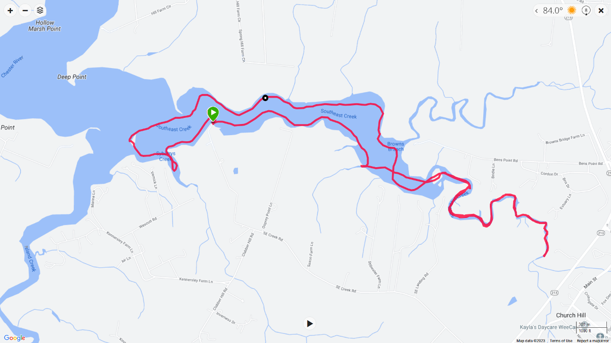
 |

|
Daphne and I launched from Southwest Area Park a little before high tide. We paddled upstream on the Patapsco River for about five miles and then explored a couple of creeks on the way back. I made sure Daphne got plenty of breaks.
We turned around after passing this unnamed train bridge. The two of us paddled under ten bridges that day. We saw a muskrat, a few bald eagles, great egrets, ospreys, great blue herons, and lots of turtles. There were also a lot of Canada geese with their young. Paddled 11.2 miles. No portage needed but we definitely could have used more water. Shallow water with a 2+ mph downstream current made for slow paddling going upstream. Here's our route. 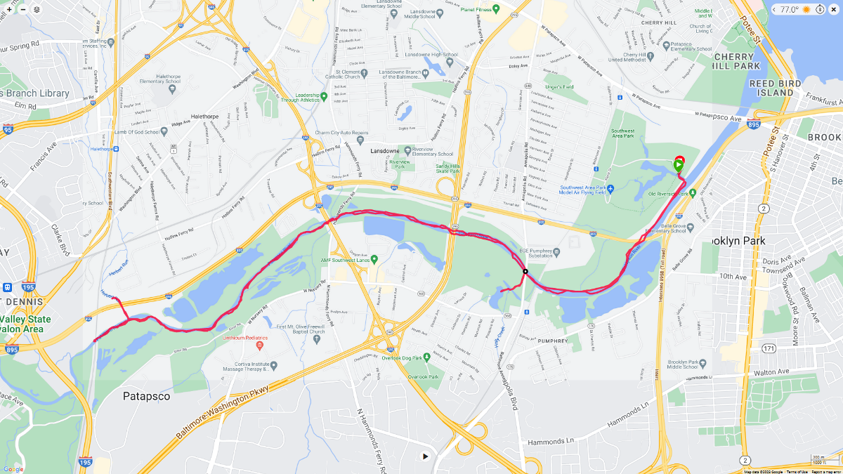
 |

|
I don't always launch from nice places. The goal of my website is to list all designated launch sites. If a few are below some people's standards, then so be it. I'll try to give them enough information so they can make that decision.
Daphne and I put in at Warehouse Creek Landing, which is not a great place to launch...but it is good enough for me. The parking area is rather muddy, despite having a lot of gravel. I'm thinking it doesn't drain well. Out on the Warehouse Creek, we hugged the shore. In one spot, we went too far upstream and I waited too long to turn around. I ended up having to get out in mucky water to lift the SUP so we could paddle back downstream. Along the way, I found a lovely house that made use of natural greenery on its pergola. My grandfather did something similar at his farm. The area was pretty natural. Unfortunately, that also meant there were a lot of natural biting insects out. I was looking for snakes. I feel I haven't seen enough this year. I saw none today, but I did see ten muskrats. Much of the creek was shallow which made paddling slow. I wasn't out at low tide but it wasn't high either. Not sure I would recommend this area. But we did have a nice sunset. Here is our route. Notice that we circumnavigated an island. Had to duck really low under a bridge to do so. Got in 8.4 miles. 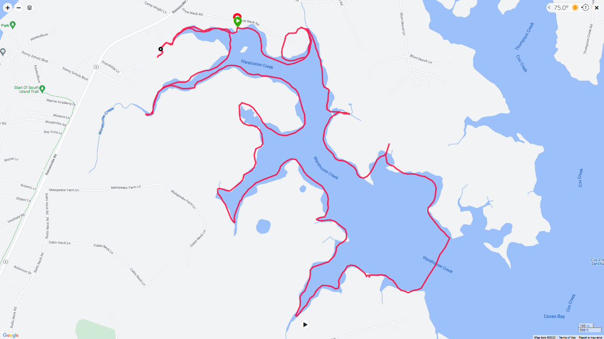
 |

|
After going for a little walk, Daphne and I paddled with the WatersEdge Kayak Club, putting in at the soft launch at Merritt Point Park.
Daphne and I were a little early so we got in a mile of paddling before the rest of the group. Then, with the rest of the group, we paddled up a very short, narrow section of Bullneck Creek on the east side of the park On the west side of the park, we passed the double paved boat ramp. We stopped at Watersedge Park where I took a group photo. Here, Greg told us how the founder of the group named it after this part of Dundalk, Maryland. I don't think I've paddled this area for 15+ years. There were more things to see than I remember. One particularly nice view was the Bear Creek Train Bridge. Turning into Lynch Cove, we spotted training boat YP-696 which has seen better days. We paddled just far up Lynch Cove to see where the "Fearless" faux pirate ship is moored at night. Our fearless leader, Greg, checks it out. I made my way to the bow to get a different view of Fearless. Daphne and I paddled 6.7 miles. 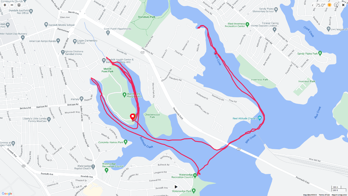
 |

|
"SUPed on the upper Mag in the Dena." This translates to "I stand up paddleboarded on the upstream portion of the Magothy River in Pasadena."
After work on May 26, 2023, I took Daphne to Beachwood Park for a walk and then paddleboarding. Here she is on her pre-paddle walk. We started by paddling upstream until we could go no further. Upstream of Catherine Avenue, we saw several fish nests. The ritual for spawning varies between species, but typically one or both gender of fish will build a nest or redd. The female will then deposit eggs and the male will fertilize the eggs externally with "milt." Some species, like northern pike and walleye, abandon the nest while others, like bass, have one of the two parents guard the nest until the fish are hatched. Nests can be easily identified by seeking circular areas that are clear of mud and debris, which exposes sand and gravel. - from Michigan State University - Sharing the excitement of spawning fish with youth Contrails or vapor trails are line-shaped clouds produced by aircraft engine exhaust or changes in air pressure, typically at aircraft cruising altitudes several miles above the Earth's surface. I call the below pic a "shallow water turtle contrail." It is when a turtle in shallow water sees me on my SUP and then quickly runs/swims away, leaving a muddy cloud behind. We paddled out to Totem Point, at least that's what I call it. Anyone who has paddled around here will recognize this distinctive landmark. Seeing this great blue heron made me think of the Prince lyrics "animals strike curious poses." Have you ever seen a great blue heron stand like this? Some sources say it is sunning itself while others say it is drying its wings, which might be equivalent. One fellow said it looked like a guy selling stolen watches out of his trench coat. Here's some other shots. We finished as the sun was just starting to get low, casting a nice glow on things. In this snapshot, Daphne often likes to stand between my legs on the SUP. We got in 11 miles of paddling. Here's our route. 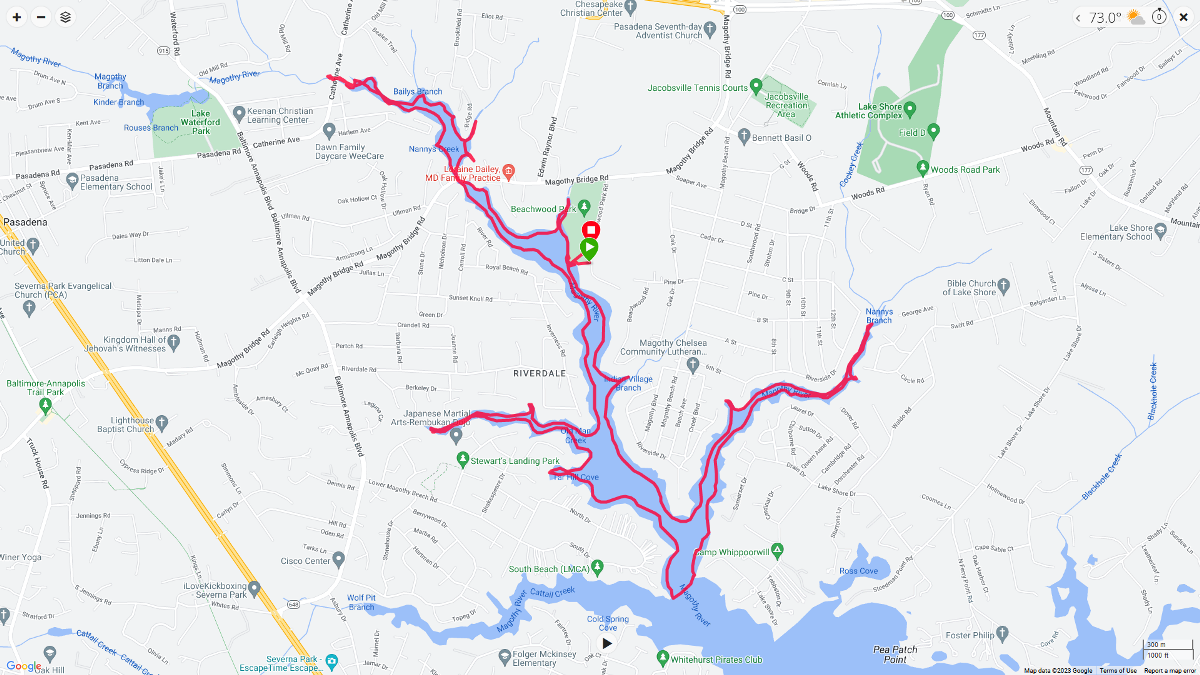
I wasn't feeling the best before I started paddling. Maybe I'd been pushing it too much between working long hours and getting out on the water both Wednesday and today. I paid for it by being sick during all of Memorial Day weekend. Burning the candle at both ends, not getting enough sleep, and too much caffeine will do it to me.  |

|
Bladensburg and Savage have something in common...Commodore Joshua Barney. He is Savage's hometown hero.
During the War of 1812, Commodore Joshua Barney made a heroic stand at the Battle of Bladensburg against overwhelming odds. Even after several thousand militiamen had fled in the face of British bayonets and fire, Barney's ~500 sailors and Marines stood their ground. Armed with hand pikes and cutlasses, they launched a successful counterattack against the British infantry. Only when hopelessly surrounded did Barney, by then seriously wounded, order his officers and men to disarm their guns and retreat. At their commander's insistence, they reluctantly left him lying next to one of his cannons to await capture. After being captured by the British, Barney was congratulated for his bravery and released. - based largely on park information sign Perhaps the cannon that Barney lay next to resembled the one shown here. Prior to launching, I took Daphne for a short walk in Bladensburg Waterfront Park. From atop the Bladensburg Park Pedestrian Bridge, we saw this carp. I'm guessing it was ~28" long. Below this same bridge, we saw dozens of carp in the shade. The two of us launched onto the Anacostia River at the ramp while lots of young people prepared for rowing practice. Daphne and I made our way downstream. Then we paddled up Dueling Creek. If you want to know how the creek got its name, read High Tide and Exotic Blooms. We managed to get a half mile upstream which is the furthest I've ever gone...yes, it was high tide. Under the Amtrak railroad bridge, one will find numerous barn swallow nests. I saw something in this one, and after zooming in, was surprised to find it occupied by a snake! We paddled into Kenilworth Marsh and along Kenilworth Aquatic Gardens. I saw two snapping turtles and five muskrats. This has been a good year for muskrats. I also saw the remains of a beaver dam and lodge. There were lots of interesting plants to see. Here's Daphne and me at the confluence of the Anacostia River and Kenilworth Marsh. On the right is a catalpa tree. As the sun got low, we spent a little time in the Bladensburg Wetlands. There were some other folks using the boat ramp so we paddled around and picked up trash while waiting. There is never a shortage of trash on the Anacostia. If it wasn't for that, the place would be gorgeous. We got in eight miles of paddling. This area is a great place to explore, but only if you go near high tide. 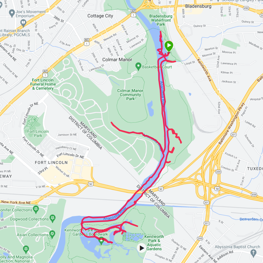
 |

|
I'd already done two trips this year paddling on the Susquehanna River at the Conowingo Islands so I could write Promoting the Beauty of Nature at Conowingo Islands. On both those trips, I brought my SUP. But for my skill level, I wasn't comfortable paddling much further upstream than the northern tip of Upper Bear Island where the current was strong. For that, I needed a kayak.
I launched my Prijon Catalina from Muddy Creek Access. The National Weather Service - Susquehanna River at Harrisburg website read 3.3 feet so I was not expecting anything too challenging, but I knew the closer I got to the dam, the faster the current would be. 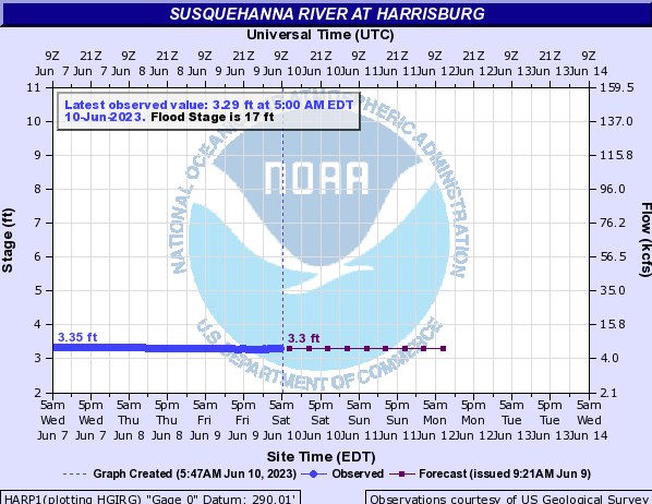
I started kayaking upstream on the west side of Lower Bear Island and Upper Bear Island. I saw lots of big, beautiful boulders. It is easy to only look at the big things when you're paddling in this area. But there are plenty of things to see at the micro-level too. Here's one of several dragonfly exuvia that I found clinging to a rock. I tried to find a way to get back to the main part of the Susquehanna without having to portage or backtrack. In the end, I had to do a minor portage through a shallow area between Crow Island and Upper Bear Island. Safe Waters - Holtwood said Holtwood Dam was releasing water at a rate of 11,600 cubic feet per second. That wasn't significant but it was enough so I had to paddle pretty hard to get through a downstream flow of ~4 mph around the Norman Wood Bridge (route 372). In the below picture, you can see water flowing over a rocky dropoff just downstream from the bridge. Continuing upstream against a fairly strong current, I stopped at the big orange barrels that tell boaters not to get any closer to the dam. I paddled downstream on the main part of the Susquehanna. By the time I got past Deepwater Island, the current was barely noticeable. I took my time, appreciating the beauty of the giant rocks. I saw a few waterfowl and raptors such as this bald eagle. Notice it has a fish in its talons. I wasn't able to identify everything I saw. On several rocks I saw these circles which looked like a place that a barnacle might have clung onto but the Susquehanna in this area is fresh water. Each circle was about as big as a half dollar coin and the ones I saw were generally three to eight feet above the water. Some people thought they might be the egg remains of some type of aquatic insect but if that were the case, I don't think they would have been so high up. Later in the morning, the sky started to get hazy. This is the result of smoke from the Canadian wildfires. See June 7, 2023 for more information. I finished my 9.5 mile trip as a lot of folks launched from Muddy Creek Access. Notice how the trailered boats launch on the downstream side while the kayaks launch on the upstream side. Here is my route. 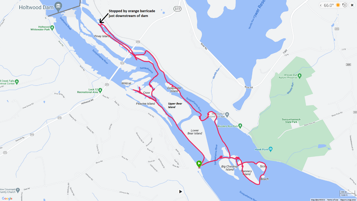
My day wasn't over. I drove north for a second kayak trip that day. See Susquehanna Petroglyphs.  |

|
After spending the morning kayaking at Conowingo Islands, I set out to see the petroglyphs on the Susquehanna River.
What are petroglyphs? According to a sign at the Indian Steps Museum, In the 1930's, Dr. Donald A. Cadzow, an archaeologist with the Pennsylvania State Historical Commission, made a thorough study of unusual carvings or peckings on large rocks in the Susquehanna River. These markings are commonly known as petroglyphs or Indian pictographic symbols. Today, two major sites contain such markings, the Big Rock Island [aka Big Indian Rock] and the Little Rock Island [aka Little Indian Rock]. Located about 1/2 mile below Safe Harbor Dam, near the mouth of the Conestoga [River], these islands are more visible when water in the Susquehanna River is lower than usual. The carvings or petroglyphs on Susquehanna River rock islands are an amazing combination of dots, lines, circles, animal tracks, abstract markings and zoomorphic or animal like forms. From these wide varieties of carvings, one could conclude that more than a single Indian culture was involved in this long past form of telling stories. The age, meanings and Native Americans responsible for these rock carvings or peckings are not known. They occur throughout Pennsylvania but most commonly in the western part of this state. It has been reasonably established that early Indians used pictographs drawn on the bark of peeled trees or woven into wampum belts to illustrate the exploits of hunters and warriors, to seal political treaties and other milestones. Illustrations with conventional figures helped to cultivate memories of such events. Unfortunately, these methods of expression were not capable of preserving the exact information needed to convey ideas from age to age with scientific precision. While types and tendencies have been classified according to certain cultures, no true explanatory key has been found to unlock the mysteries of ancient Indian picture writing on nearby islands in the Susquehanna River. The last time I kayaked out to see the petroglyphs on the Susquehanna was October 4, 2009. After seeing an event announcement titled Petroglyphs Canoe Paddle by the Natural History Society of Maryland, I figured it was time for another visit. Their trip's description reads Take a step back into history with this unique paddling experience! Located on the Susquehanna River just south of the Safe Harbor Dam is one of the largest concentrations of petroglyphs in the Northeast U.S. Found primarily on two islands named Big Indian Rock and Little Indian Rock, these petroglyphs are thought to be as many as 1,000 years old. The Algonquian Indians created these rock carvings that can still be enjoyed today, accessible only by kayaks, canoes, or small motorized boats. In 2009, I launched from Pequea but today I decided to check out Safe Harbor Park which would put me much closer to the petroglpyhs by allowing me to launch near the mouth of the Conestoga. Scouting the area, I saw several common mergansers. I found a boat ramp at the park but all the designated parking spots near it were taken. Thinking back, I should have just parked on the grass or moved my car further away after dropping off my boat. Instead, I did a very steep commando launch further downstream which would allow me to avoid portaging through the riffles on the way back. I don't recommend doing this. Indian Rock Island

Big Indian Rock

Little Indian Rock

Pequea

 |

|
On June 24, 2023, the Arleigh Burke-class guided missile destroyer, USS Carl M. Levin (DDG 120), was commissioned in Baltimore, Maryland. This Navy destroyer is named after Senator Carl Levin, who served in the U.S. Senate for 36 years from 1979-2015. For more information, see
The next day, Daphne and I launched my SUP from Canton Waterfront Park to see this ship, the Northwest Harbor, and the Baltimore Inner Harbor. We paddled 10.8 miles. Here is the Levin. I took this picture from the floating pier where the mini-Statue of Liberty stands. This pier is part of a network of piers that have been removed. Only this one section of pier remains and it does not connect to anything...it is basically an island. I don't expect it will be there much longer. Though newer, I think this ship is more primitive than the USS Zumwalt guided missile destroyer, which I saw in Baltimore on October 14, 2016. In the area where the mini-Statue of Liberty stands, there are lots of recycled piles. Many of them are covered in barnacles. Lighting wasn't the best so I figured I'd paddle around and come back to take more pics once the sky cleared up a bit. Paddling downstream, we saw the Lazaretto Point Lighthouse and a cruise ship. Crossing the harbor, I paddled upstream on the west side. The police didn't mind me passing in the channel near the Levin though I don't think they would have appreciated me stopping to take pics so we just continued. Exploring the area further upstream, we found abandoned train tracks that went into the water. I wondered if there is a train down there. Maybe it was a marine railway for ship repair. Here is some of the other stuff we saw that day. We saw the Kaiulani, a schooner from Hawaii docked next to Lady Baltimore. I'd never seen the Kaiulani before. Here is our route. By the time we came back to the pier where the mini-Statue of Liberty stands, the USS Levin had left. I was hoping to get some pictures of it underway but that opportunity is no more. 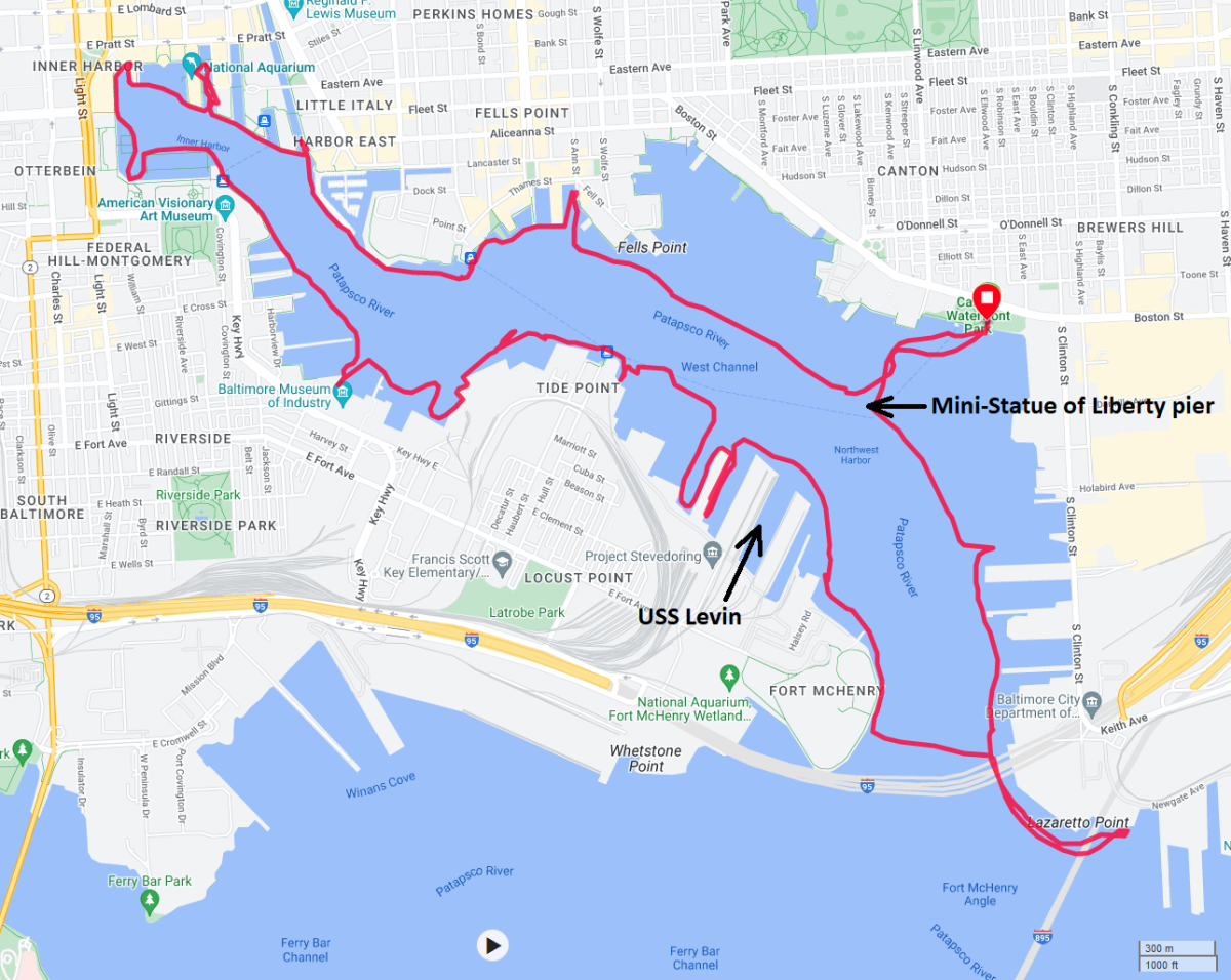
 |

|
Daphne and I arrived bright and early at Kingston Landing. Unfortunately, it wasn't really bright. We had a lot of smoke from the Canadian wildfires that made for a dark day.
The area around the launch site has some beautiful flowers including both white and dark pink hibiscus (rose mallow) flowers along with hedge false bindweed, the latter shown below. My goal was to see the observation tower at the terminus of the former 2000-foot-long floating boardwalk in Kings Creek Preserve which I describe in Kings Creek - A Water Trail Fit for Royalty. Looking at satellite photos, I figured this creek, an unnamed tributary of the Choptank River, might be interesting to explore. But I never saw it because I overshot my mark and explored the wrong creek. When I return, I need to make sure I don't explore the creek next to the duck blind. It is the one before that. I guess I was drawn to the bald eagle at the blind. Eagles weren't the only thing I saw at the blind. There was also a SUP laying upside down in the water in a shallow area. I saw no signs of distress so I went ahead and explored the creek first. Lots of tall phragmites obstructed my view of most things beyond the creek. Had I been in a kayak, the view would have even been more limited. I saw muskrats, turtles, and a river otter. The latter was very vocal in its snorting sounds. It watched me curiously and swam by a couple of times but I wasn't able to get a photo. Back at the SUP, it took me a few tries before I found the best way to tow it back 1.8 miles to where I started. Most SUPs aren't made for towing. In the end, I used parachute cord to tie onto one of the eyelets and towed it back upside down. In the below snapshot, I photoshopped the manufacturer logo off the board. Here is my route. 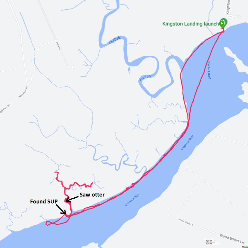
I called a couple of local kayak/SUP stores to ask if anyone reported a lost SUP or if they had a lost and found. The answer was no for both. I took Daphne for a walk in Easton before heading home. It was a rough drive because the smoke made my eyes very dry and I felt like I couldn't blink enough. At home, I posted what I found on some of the SUP social media groups and asked folks to spread the word. If this is yours, please message me with the make, model, length, and any distinguishing characteristics. Feel free to forward / cross-post this. I also called the Coast Guard and sent them a photo of the SUP.  |

|
Daphne and I launched from Elk River Boat Launch at 0725 to explore Little Elk Creek at high tide. This was my first time in this area. I really like it and plan to return this year to check out Big Elk Creek.
Like yesterday, the smoke from the Canadian wildfires was terrible. A total of ten fish jumped onto my SUP. This is a record. I usually don't know they are there until it is too late but as soon as I see them, I throw them back in the water. I paddled under several bridges. This is highway 40 at Little Elk Creek. Here's Daphne and me at the train bridge just south of highway 40. We explored a circuitous tributary off Elk River. It was grassy but I didn't see any phragmites. Instead, these plants were diverse and generally short enough for me to see over the top of them. But it was nowhere as scenic as the tree-lined Little Elk Creek. Daphne and I saw a lot of pickerelweed flowers. Supposedly, it makes a tasty snack. Here's one with a pollinator. It was a very nice trip, though it would have been spectacular had it been sunny. All these hazy days are bringing me down. I saw only two other boaters when I was on the water but there were a lot of folks preparing to launch when I landed at 1030. We got in ten miles. Here is our route. 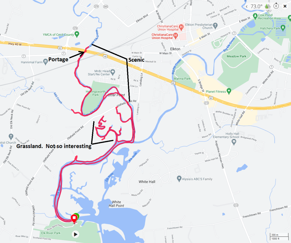
Next, I took Daphne for a walk out to the Turkey Point Lighthouse. Upon arriving home, I realized that I left my paddle next to the boat ramp. You can see where I left it in the previous photo. I called the phone number listed for the park and left a message. Then I drove back. It takes an hour and 20 minutes to get there, assuming no traffic. I did not find my paddle. It did not have my name or phone number on it. I doubt I will ever see it again. There aren't many material things I have a deep connection with but my Kenalu Konihi 95 is one of them. Needless to say, I was very sad.  |

|
Daphne and I launched from Mariner Point at 0730. Surprisingly, all the non-trailered vehicle parking spaces in lot A were taken. This place is quite popular and the fishermen are early birds.
Less than twelve hours prior to launching, it rained 3.22 inches in the area, according to the National Oceanic and Atmospheric Administration (NOAA). That made the water very brown from all the runoff. I paddled south to the Gunpowder River then west to the mouth of Big Gunpowder Falls. I timed my trip with the tide so I would have a little push going upstream but all the rain meant I was paddling against an ~1 mph downstream current. But this was a good test for my new SUP paddle, a QuickBlade UV88 Hex Flex. We saw several bald eagles. This is my patriotic photo to commemorate the holiday. I see lots of kingfishers but this is one of the few that posed long enough for me to take his picture. The lower part of the Big Gunpowder is a little wide and marshy. But it eventually narrows and becomes tree-lined, which I prefer. Combined with clear skies (no smoke from the Canadian wildfires), the scenery was excellent. I paddled under Pulaski Highway (route 40) and then a scenic train bridge. Here is a view of the latter. About a tenth of a mile upstream of the train bridge, we came to whitewater. It would have been difficult to have portaged past it so I figured we would take a break here before heading back. The last time I paddled here was 2005. The rocks at our rest area had unusual patterns of light and dark swirls. On the way back, we did some exploring. It was hot and humid so Daphne got dunked in the water a few times to get cooled off. She did not appreciate this. We returned partly via Little Gunpowder Falls. Here is our route. 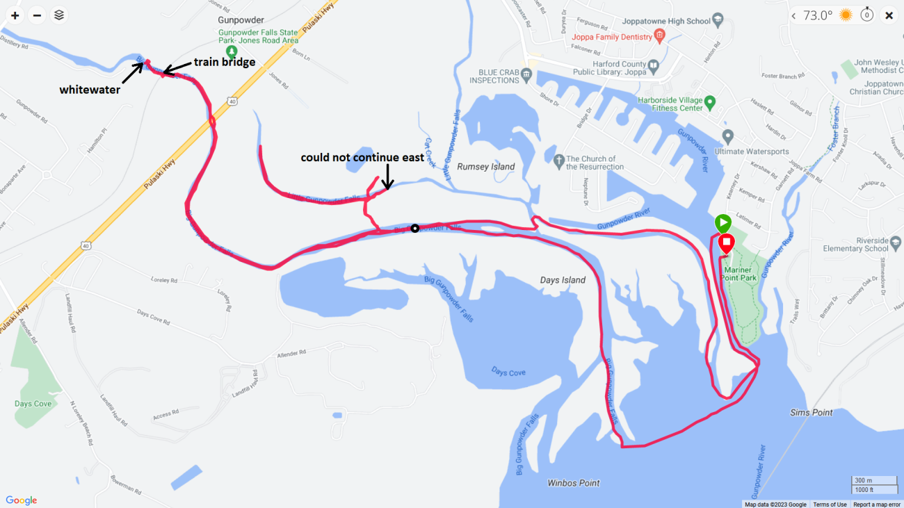
So how did the new paddle do? It was excellent. It felt a lot like the old one in terms of how much water it moves. What felt different was the shaft. I love that it is more "grippy." The smaller diameter will take some getting used to but I think I am using less forearm strength to hold it. Lots of paddlers were launching by the time we returned. I much prefer to be out early when things are quiet and wildlife is more active. I took Daphne for a 40 minute walk on the nice, paved trails in the park. Then I stopped at Royal Farms to pick up some fried chicken and potato wedges. I like their chicken motif mailboxes but this store took it one step further. I didn't know what all was in the runoff causing the water to look so brown so when we got home, Daphne got a good bath and I washed her personal flotation device (PFD).  |

|
The Ara Libertad is a tall ship used to train the Argentine Navy.
One of the largest and fastest tall ships in the world, holder of several speed records, she was designed and built in the 1950s by the Río Santiago Shipyard, Ensenada, Argentina. Her maiden voyage was in 1961, and she continues to be a training ship with yearly instruction trips for the graduating naval cadets as well as a traveling goodwill ambassador, having covered more than 800,000 nautical miles (1,500,000 km) across all seas, visited about 500 ports in more than 60 countries, and trained more than 11,000 navy graduates. Ara Libertad is the sixth longest tall ship and the third heaviest in displacement. She maintains a crew of 357. - from Wikipedia - ARA Libertad (Q-2) Daphne and I launched from Canton Waterfront Park at 0740 to see this ship, the Northwest Harbor, and the Baltimore Inner Harbor. There was a small window of opportunity over the weekend where the cloud cover was expected to be low. My goal was to photograph the Libertad during this time. Many of the piers west of the launch area had been removed. I think a major renovation is taking place. This made it easy for me to paddle up to what I believe is an unnamed lighthouse at the end of Lighthouse Point. "J.S. Young 1883" is written on it. On the south side of Lancaster Street, there are several Living Classrooms murals. But the ones shown below are located under the South Central Avenue bridge. They are well hidden so you won't see them unless you have a boat. In this same area, near the Living Classrooms garden, we also saw a beehive. As the skies started to clear up, we made our way to the featured event. The morning sun was shining quite nicely on the Libertad for a few minutes. On our June 25, 2023 trip here, I thought I saw a black-crowned night heron in flight. Today, I confirmed there are two such birds in Baltimore. This one was very willing to sit still and let me take its picture. I was told they've been seen in Fells Point too. We saw several people paddling a couple of dragon boats. Along with the dragon boats, we saw folks doing group exercise and so many joggers that I thought there was an organized race taking place. But I figured that was not the case because nobody was wearing a number. There was also some little festival getting set up near the launch site. I'm not a big city person but I have to admire how active so many people in Baltimore can be on a Saturday morning. Here's our route. 
After paddling, I took Daphne for a 40 minute walk in the city.  |

|
Also known as the American lotus, Nelumbo lutea is the only lotus native to the United States.
After checking a day-old post from the Sassafras Riverkeeper Facebook page, I determined that the water quality was good and the flowers were blooming on Dyer Creek and Woodland Creek. Both are tributaries of the Sassafras River. I was up at 0445 to beat the traffic, avoid the heat, and ensure I had good lighting for photography. Daphne and I then drove out and launched from Fredericktown Boat Launch. We paddled downstream and across the Sassafras where we commenced exploring Dyer Creek. There were a few lotus flowers blooming but not many. Maybe we were a little too early. I saw a great blue heron's tongue. We pulled over at a small beach on the northwest side of the mouth of Dyer Creek. There were far more bald eagles than I could count. I haven't seen this many for awhile. I made my way into Woodland Creek and then headed south. This is where I hit the jackpot. Lots of lotus flowers, especially on the east side. Here's one with a bee hovering above. These flowers measure 7–11 inches in diameter and have 22-25 petals. Once the sepals fully retract and allow the petals to open wide, the sexual organs are revealed in the center of the lotus blossom. The flat-topped, usually yellow cup-like structure in the middle is called the carpellary receptacle. - from Garden Guides - Parts of a Lotus Flower This is an overhead view of a carpellary receptacle. Atop the receptacle are many bumps that are stigmas, the tips of the female pistils that each houses an ovule. This fast-growing species can reportedly expand from six plants that are spaced 10 feet (3.9 m) apart to cover an acre (0.4 ha) in a single growing season. - from University of Florida - American Lotus, Yellow Lotus: Nelumbo Lutea It was a very hot and humid day. I kept my eye on Daphne and made sure she had plenty of water. I also massaged clean water into the fur on her head and the back of her neck to help her stay cool. I saw flowers in various stages of development. Before the flower opens, it starts as a bud. After the flower matures, the sepals fall off and the carpellary receptacle becomes a seed pod. Eventually it turns woody and it releases large seeds. Dried pods are used to add interest to flower arrangements. I am always searching for the perfect lotus flower. In my opinion, this was the prettiest one I saw that day. Much of the plant is edible—including the flowers, leaves, seeds, and tuberous roots—and was used as food by many Native American tribes. - from Matthaei Botanical Gardens and Nichols Arboretum - Native Plant of the Week: American Lotus I saw quite a few other edibles on Woodland Creek such as persimmons, paw paws, and wild rice. I paddled around an unnamed island that appeared to have abandoned nests from a cormorant rookery. Had I been there a month ago, I might have seen them. I also paddled past Daffodil Island, which, in previous years, has held a great blue heron rookery. But I saw no signs of any such rookery. We got in ten miles. Here's our route. 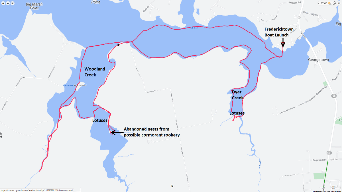
On the way home, we stopped at the Chestertown Farmers Market where I picked up a smoothie, dog treats, bread, granola, and flowers. The drive home was terrible. It should have taken an hour and 15 minutes to get from Chestertown to Savage but instead it took two hours. Three eastward lanes were open on the Bay Bridge but only two westward lanes were open and that was where most of the traffic congestion was.  |

|
It was the last day of the Lotus and Water Lily Festival at
Kenilworth Aquatic Gardens. Not having my fill of flowers from last weekend, I took Daphne to launch the SUP at Anacostia Park. The plan was to ride the tide upstream to the Gardens, spend some time there, and then ride the tide downstream back to the park.
We were a little early, so we started with the more scenic route...paddling on the west side of Kingman Island to Kingman Lake. But we didn't make it far, the water was too low. It was 3.5 hours before high tide. I figured we'd try again on the return trip. I paddled in the Anacostia River past the National Arboretum then to Kenilworth Marsh. There, I met Michael Brown who pointed out a pair of roseate spoonbills in a tree. Had he not identified them, I would have just throught they were great egrets since there were several other such birds interspersed in the tree. I normally only see spoonbills much further south (i.e. Florida). This is the first time I've seen them in the mid-Atlantic region. Perhaps this is one of the few benefits of climate change. Roseate Spoonbills get their pink coloration from the foods they eat. Crustaceans and other aquatic invertebrates contain pigments called carotenoids that help turn their feathers pink. - from All About Birds - Roseate Spoonbill I saw various people with some very serious cameras taking shots of the spoonbills. But they weren't able to get close to them on land. I did my best not to spook the birds, keeping my distance, moving slowly, and making very little noise. Then a dozen or so kayakers came by. They were definitely not quiet and paddled right up to the birds. But they didn't fly away. So I approached them and took hundreds of snapshots. One of them fell asleep. I eventually paddled away with the birds not having moved more than a few inches since I approached. They were amazingly cooperative and not the least bit camera-shy. Here are my five best photos. After I got home, I posted my spoonbill photos to the MD Birding Facebook Group. As of July 26, 2023, my pics have 347 "likes." I landed and pulled my SUP ashore, then locked it and my paddle to a tree. I put my valueables in a backpack and walked 0.45 mile to Kenilworth. There, I joined hundreds of others for the "Festival Finale." As Daphne and I walked, we could hear music from the "Nl Bemya African Drum and Dance" performance. We saw lots of lotus flowers. Some had the same white to pale yellow coloration as the American lotus flowers I saw on July 15, 2023. Most of the lotus flowers were pink, which leads me to think they are Nelumbo nucifera (aka Indian lotus). Like the ones I saw last week, some had much more visible carpellary receptacles (yellow cup-like structures) than the others. Like all lotus plants, the leaves are hydrophobic, meaning that despite the muddy waters from which it grows, the leaves remain perfectly clean. The lotus flower also grows unadulterated by the mud and is lifted high above the murky water on the stem. - from sign at Kenilworth Aquatic Gardens Because of its purity and beauty, the lotus plant is revered by Buddhists as an icon of detachment from worldly things and enlightenment. - from sign at Kenilworth Aquatic Gardens [The lotus] is revered by Hindus as a symbol of beauty and spiritual liberation. The "Sacred Lotus," as it is commonly called, is the national flower of both Vietnam and India. - from sign at Kenilworth Aquatic Gardens A mature carpellary receptacle becomes a seed pod. Here's one showing its seeds. Dr. Ichiro Ohga, a Japanese Botanist, discovered lotus seeds in a dried lakebed in Leoning province, China in 1919. Dr Ohga brought the seeds to the United States. In 1952, Kenilworth Aquatic Gardens got the seeds to sprout in our hot houses. The seeds were up to 1,000 years old. The Manchurian Lotus are the oldest seeds to ever germinate successfully and are grown here today. - from "Dr. Ohga and the Manchurian Lotus" sign at Kenilworth Aquatic Gardens The seed pods shown here are not necessarily from a Manchurian Lotus. We also saw lots of beautiful flowers that were not lotuses. Here's a swamp rose mallow that was growing wild. Most, if not all, of the other flowers I saw were some type of water lily...at least that's what I would call them. Of all the water lilies grown at Kenilworth Aquatic Gardens, the Victoria amazonica (formerly named Victoria regia), Victoria cruziana, and the hybrid, Victoria 'longwood' are among the most popular. These lilies are night-blooming. Flowers grow to over 12 inches wide and bloom in early September. In their native South America, the lily pads may grow an inch per hour and reach up to eight feet in diameter. Here, the pads typically grow as large as four to six feet. - from "Victoria amazonica" sign at Kenilworth Aquatic Gardens I would have thought this is a lily but it is a Blue lotus of the Nile. Here's some non-flower stuff I saw at Kenilworth that day. We explored the rest of Kenilworth Marsh. There are always a lot of great egrets there. Then we paddled back downstream on the Anacostia River. This time, we went on the west side of Kingman Island. An hour after high tide, the water was deep enough to get all the way around the island. The area north of the Benning Road bridge is very scenic. Here is our route. We paddled nine miles and walked two. 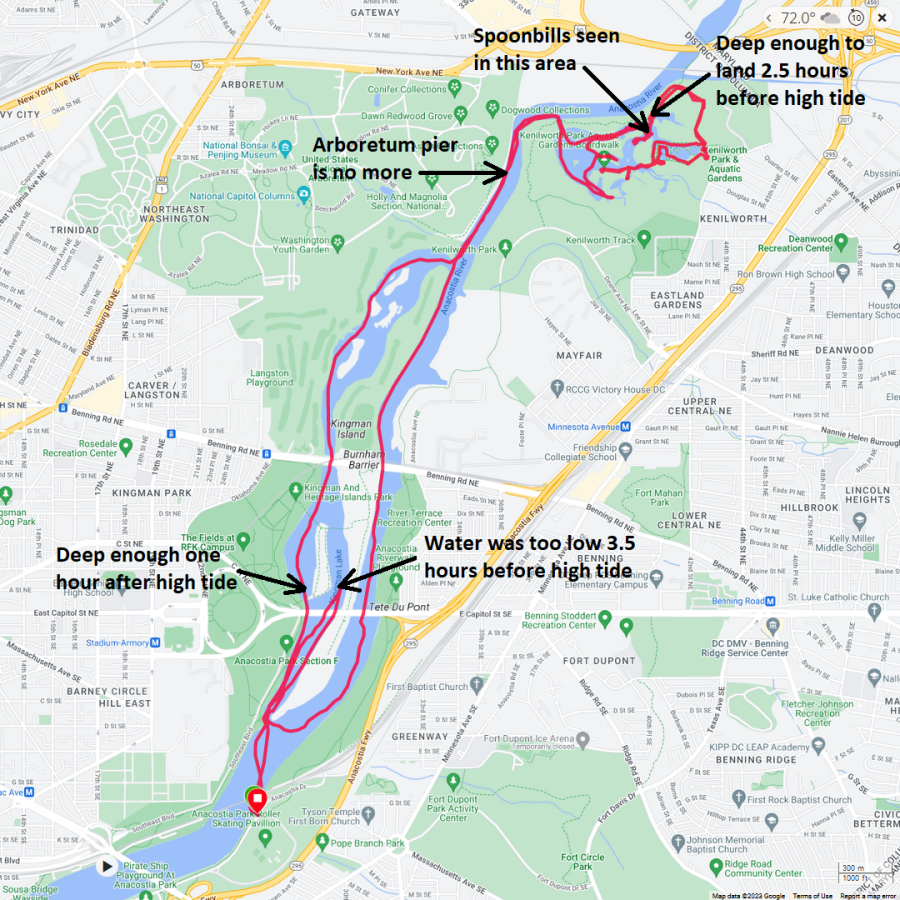
The waters of Kenilworth Marsh are tidal, with an average range between tides of 2-3 feet. - from sign at Kenilworth Aquatic Gardens  |

|
Out on the Chesapeake Bay, the wind was 2-3 mph on a sunny morning. This doesn't happen very often so I made sure to get out on open water and see something scenic.
I tried to get access to Mayo Beach Park but their weekend passes were all taken. In contrast, Beverly Triton Nature Park is not as popular so I was able to get in there. I brought Sara and Daphne with me. This is the first time I've been to Beverly Triton Nature Park since they renovated the place. It looks new. There are various hiking trails that I plan to return to and explore when it isn't so hot. The goal was to visit the Thomas Point Shoal Lighthouse. I've been there before several times but Sara and Daphne had not. Usually, I am solo when I visit so I have nobody to take a picture of and nobody to take a picture of me. Photos of lighthouses are nice but I much prefer to have someone in the shot. Today was that opportunity. The Thomas Point Shoal Light, also known as Thomas Point Shoal Light Station, is a historic lighthouse in the Chesapeake Bay on the east coast of the United States, and the most recognized lighthouse in Maryland. - from Wikipedia - Thomas Point Shoal Light The need for a lighthouse at Thomas Point was recommended in 1821. The first Thomas Point Lighthouse [not shown here] was built after Congress provided $6,500 on May 26, 1824 for its construction. Over time, erosion reduced the seven-acre acre parcel on which the lighthouse was built to a two-acre island, separated from the mainland by a strip of water. The lighthouse remained standing until 1894, when it too was lost to erosion. - from Lighthouse Friends - Thomas Point Shoal Lighthouse The State of Maryland conveyed five acres of submerged land to the Federal Government on October 28, 1874, and Thomas Point Shoal Lighthouse was ready for its inaugural lighting on November 20, 1875, the same date the old Thomas Point Lighthouse was discontinued. - from Lighthouse Friends - Thomas Point Shoal Lighthouse Here's Daphne and me next to this 1875 lighthouse. In 1972, the station felt the effects of tropical storm Agnes, which raised twenty-three-foot waves and brought them crashing down upon the cottage and foundation. - from Lighthouse Friends - Thomas Point Shoal Lighthouse The Annapolis Maritime Museum houses exhibits on the lighthouse and serves as a shore-departure point for tours to the lighthouse. - from Lighthouse Friends - Thomas Point Shoal Lighthouse We are scheduled to return in August for one of these tours. The water was smooth as glass and we were hoping to see dolphin or rays but we saw none. Here's our route. We paddled eight miles. Note that Google Maps is off a bit in the location of the lighthouse. The whole trip took about 2 hours and 25 minutes. That includes 15 minutes just hanging out and taking pics at the lighthouse. 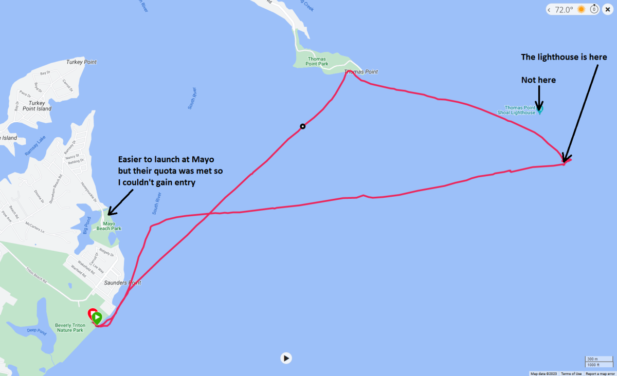
 |

|
I had heard about the world's largest rubber duck coming to Maryland. At first, I wasn't too interested but folks were making quite a fuss over it, and that piqued my interest. The more I learned about it, the more I wanted to see it.
The duck is a little over six stories high, 64 feet wide, and 74 feet long... - from The Baynet - Exclusive Interview With Creator Of The World's Largest Rubber Duck, Craig Samborski This duck was the feature attraction at Leonardtown Wharf Fest, an event I had never attended. Norma, Daphne, and I could have just driven into town but paddling there seemed more appropriate for us. So we launched from McIntosh Run / Port of Leonardtown Park and then paddled my Ocean Kayak Cabo tandem to town. It was near low tide so we had to do a lot of portaging, which we expected. What I didn't expect were all the other folks on the water. I figure they rented boats at the festival. But it was all good; it was nice to see so many families getting out into nature. Speaking of nature, I saw a northern water snake. For the Cabo, I built a padded platform so Daphne can rest in front of Norma's feet but she often prefers to sit between Norma's legs. From where we launched, there was a sign that read Leonardtown Wharf closed for duck event. Use Camp Calvert Road for kayak/paddleboard landing. At the wharf boat launch, the outfitter rented kayaks and yellow inflatables for kids to wade into the water. Still, a few paddlers with their own kayaks carried their boats up the beach to the grass so it was clear that the "wharf closed" sign was not enforced. But that didn't matter to us since there was plenty of room at the pier so I locked my kayak there and then we ventured ashore at Leonardtown. The duck was indeed as big as they claimed. Here's Daphne and I in front of it. According to WMAR2 News - World's Largest Rubber Duck coming to Maryland, Craig Samborski, the man behind the duck, confirmed this is "Mama Duck's" first trip to Maryland. The duck weighs about 8,000 pounds and it takes about 90 minutes to inflate and deflate her. We saw several hundred people at the festival and in town. Yet, I managed to find fellow kayaker Marla A. Leonardtown isn't really set up well for such a big festival. The waterfront area isn't very big and the main part of town is quite an uphill walk. Norma, Daphne, and I followed the slow-moving herd into town and then grabbed lunch at Social on Fenwick. Then we checked out some of the vendors and shops around town. We found a place that makes benches from old tailgates. When is the last time you saw a Datsun? 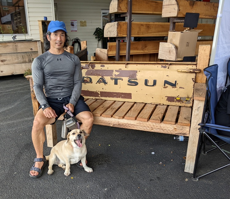
At another place, we saw the world's largest puzzle. I'm guessing it was about 30 feet long. Before leaving, we picked up dessert at Frog Town Ice Cream. We paddled a mere 5.7 miles.  |

|
Recall that on July 23, 2023, I paddled to the Thomas Point Shoal Lighthouse. Today, I returned to tour the inside...something I'd never seen before. Joining me were Norma and Sara and Don.
We didn't visit by kayak or SUP, so why am I writing about this on my kayaking blog page? Well, anyone who has paddled in this area for a long time is well aware of this lighthouse and there is a good chance they've seen it from the outside. But very few have been inside because it is not open to the public. The four of us were given this opportunity through the Annapolis Maritime Museum's Thomas Point Shoal Lighthouse Tour. We met behind the museum and boarded the Bodacious, a Chesapeake deadrise boat. This took several museum volunteers and about 16 passengers out to this beautiful lighthouse. The lighthouse sits on nine cast-iron screwpiles, six of which are spaced at 60-degree intervals around the perimeter of the central piling. The piles are screwed 11 feet 6 inches into the bottom of the [Chesapeake] Bay. The lighthouse is a 35-foot diameter, 1 1/2 story hexagonal wood structure, 48-feet tall. It was fitted with a fourth-order Fresnel lens. The interior of the lighthouse was designed for a principal keeper and his assistants. It has 2 bedrooms, a kitchen & sitting room. There are storage areas for food, clothing, supplies & water. Thomas Point Shoal lighthouse was the last lighthouse on the Chesapeake Bay to have a keeper & is the last cottage style screwpile lighthouse left in its original site in the Bay. The metal support structure received major repairs in 2019 & 2020. As of 2020, the lighthouse remains an Active Aid to Navigation & NOAA Weather Station. - from "Thomas Point Shoal Lighthouse" sign in the lighthouse Thomas Point Shoal Light was built in 1875 and designated a national historic landmark in 1999. This structure is attached to the outside of the lighthouse. Can you guess what it is? It isn't a phone booth. That's right! It is an outhouse. To the north lies... [An] ice-breaker consisting of "three wrought-iron screwpiles, connected together by double channel-iron beams, surmounted by heavy cast-iron caps, securely bolted together" was positioned ninety feet north of the light station along the axis of the current. Over the years, tons of riprap have been placed about the piles to provide further protection from ice and scouring. - from Lighthouse Friends - Thomas Point Shoal Lighthouse On some of this riprap, various lighthouse keepers carved their names. Off in the distance, we could see Bloody Point Bar Lighthouse. The last time I paddled out to this lighthouse was September 17, 2022. Though the lighthouse stands in about seven feet of water and warns mariners of shoals near Poplar Island with a red sector, it is also close to one of the Bay's deepest shipping channels at 174 feet. - from Lighthouse Friends - Bloody Point Bar Lighthouse The inside of the lighthouse is like a museum. Volunteers have spent countless hours keeping things well-maintained. One of the things we saw inside was a fog bell. The fog signal consisted of a Stevens bell machine apparatus with a triple blow every 30 seconds against a 1200-pound metal fog bell which was 40 inches in diameter and 34 inches in height. The apparatus [shown here] was wound by the keeper with a winding crank and then the weights attached to the end of the cable (opposite end of the hammer) would slowly descend through a hole in the floor of the small closet, with the clockwork gears periodically releasing the hammer to strike a blow against the bell with its designed period or characteristic. The fog bell is known to have been at the lighthouse at least until 1960. - from "Fog Bell and Striker" sign in the lighthouse There was also a small library and an old hand-cranked phonograph inside the lighthouse. Rainwater was captured in cisterns, which were placed in various corners of the lighthouse. The keepers were given generous food rations and even kept some livestock (e.g. chickens and goats) below the living quarters. Visitors were divided into two groups. This is my group, led by docent Gregg G. (shown in front), as we return to Annapolis. 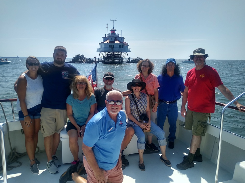
I would highly recommend this tour for anyone that is interested in lighthouses, local history, maintaining historic structures, or the Chesapeake Bay. After our tour, we had lunch at Davis' Pub, where we ran into Gregg.  |

|
Norma, Daphne, and I launched from Shore Park and then paddled up Swan Creek to see the American lotus flowers. Some people were out there in mid-July and saw very little. But today, they were at their peak of bloom.
Honey bees really like these flowers. I wonder what lotus honey tastes like. There are four bees visiting this one flower. Here's Norma, the lotus flowers, and a great egret. We saw lots of great egrets that day. Here's some pics of Daphne and me. We had a fairly strong headwind but once we got upstream into the narrow section, we were sheltered. Exploring one of the tributaries of the creek, we were stopped by a beaver dam. It was a little after high tide so things were fairly deep. If we had to turn around, it is because things got too narrow or because of obstacles in our path. In addition to the great egrets, we saw the usual osprey and bald eagles. We also saw an unusually large number of small birds. I don't know if it was the same egret but I managed to get quite a few shots of this one. We saw lots of wild rice. Maybe that's why there were so many small birds in the area. Wild rice is harvested in the fall when the flower heads have ripened and turned a rich purple. - from Insteading - Cultivating And Harvesting Wild Rice By far, the most interesting thing we saw that day was a four-inch long, white, balloon-like object floating on the water. We had to investigate. Our first thought was, "Is this natural or man-made?" Looking more closely, we could see patterns that made us think natural. Then I wondered if it was from a plant or animal. We picked it up, held it up to the light, and determined it was only full of trapped air. It felt slimy and had very little scent. I took several photos which I posted to the "MD Nature Lovers" Facebook page. I got a lot of replies with many people thinking it was some sort of egg. My chickens have laid a few softshell eggs which means there was no hard shell on the outside...just a membrane. At first, I thought that's what this could be, but as I mentioned, it was only full of trapped air. It also had something string-like hanging off one end. Norma thought it might be the organ of an animal. She was right. After considering all the suggestions I received from Facebook, I concluded it is a fish swim bladder. The swim bladder is an air filled organ used by some fish to maintain buoyancy at a desired depth and produce or hear sound. For many fish, the swim bladder has the additional role of transferring sound waves to the auditory system. And in some fish, such as drums and croakers, the swim bladder is used to make sounds and communicate with one another and other fish. - from Fishionary - Swim bladder At four inches long, it is likely this swim bladder came from something big like a large rockfish. Croakers also get quite large (up to 24 inches long) and can be found in this area. Croakers are a member of the drum family, which includes spot, weakfish, red drum, black drum and spotted seatrout. All drums are able to make a loud drumming or croaking sound by vibrating their swim bladder using special muscles. Atlantic croakers are the loudest of the drums. - from Chesapeake Bay Program - Atlantic Croaker This organ is also known as fish "maw." Fish maw is the swim bladder of large fish like croaker and sturgeon. It is one of the most expensive parts of the fish, traditionally consumed as an anti-aging health food due to its high collagen content. According to Chinese medicine practice, fish maw also nourishes one’s yin energy and strengthens one’s lung and kidney health. - from Good Food Institute - World's first cultivated fish maw shows the importance of global markets Here's a photo of fish maw in Singapore. This maw was probably left over after someone cleaned their catch. Then they threw the scraps into the water. But some of these fish maws can be quite valuable. One of the most expensive commodities on Earth is the swim bladder of a large fish [a rare croaker] found in the Gulf of California. It's a delicacy in China, where it's thought to heal arthritis and other ailments. A single bladder can fetch thousands of dollars. - from Science and the Sea - Endangered Croaker Here's our route. We got in eight miles. Paddling in some areas was a little slow due to the thick aquatic vegetation. 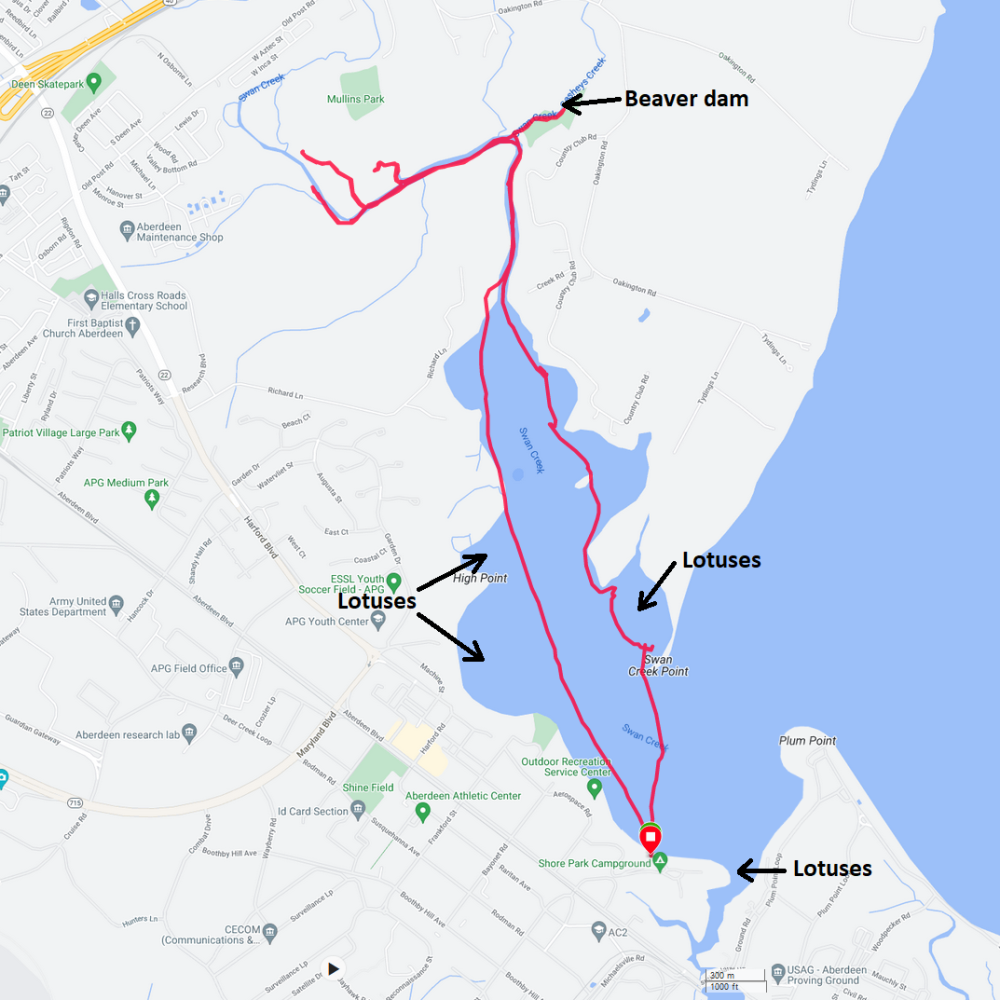
Norma saw a spotted lanternfly. I went to report it at the Maryland Department of Agriculture website but they mention, "MD residents no longer need to report spotted lanternfly sighted within Cecil or Harford counties." I've seen them there in previous years.  |

|
On August 20, 2023, Norma, her sister, various nieces, a nephew, and I went canoeing in Lake Herrington.
|

|
I often don't take out my surf ski until late in the summer. Part of the reason is that taking wildlife photos from a SUP is much easier. But by late summer, I don't see as many animals. If the wind is a little high or the skies aren't so clear, then I'm also more likely to focus on trying to balance out my training with the surf ski.
I tried to launch at Carrs Wharf, but I didn't arrive until around 0900 and by that time, all the parking spots were taken. So instead I put in at Galesville. I launched on the West River and then kayaked to the Rhode River, passing Carrs Wharf. Along the way, I saw something I don't think I'd ever seen. A lot of sea kayakers in my area know about the little Statue of Liberty in Baltimore City. But how many know about the little Thomas Point Shoal Lighthouse? I found it on the north side of the Rhode River at what appeared to be a private community park. I saw a snake swimming, a few bald eagles, osprey, and egrets. Here's a snowy egret. The wind wasn't bad but the boat traffic was. Doing open water crossings meant having to endure the "washing machine effect" where waves come from all directions, creating an unpredictable chop. I was much happier paddling in more protected waters. Here's my route. My trip took about 4.5 hours. That includes plenty of breaks and some photo opportunities. I got in 21.1 miles. My abs were sore. 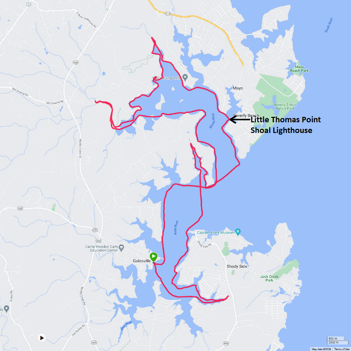
 |

|
Norma, Daphne, and I visited the Bel Air Farmers Market, which, in my opinion, is one of the better farmers markets in the area. It is very dog friendly and has a variety of great vendors, many selling what they grow locally. Harford County is pretty farm-focused and this market gives them a good outlet to sell their goods.
We continued our drive northeast into Cecil County and then ended up at Marina Park in Elkton. Here, we launched onto Big Elk Creek and paddled upstream. We could only get about a mile upstream without having to portage. We did several minor portages through shallow water until we came to a five-foot-high dam. The three of us portaged around it on the right heading upstream and then over it returning downstream. We had to be careful that the metal on the dam did not damage the boat. I saw lots of fish and a few snails in the water. Coming back downstream, Norma, Daphne, and I pulled ashore at a drainage pipe and went ashore to check out the Elkton Fall Fest. We were not impressed. Continuing downstream, we checked out an unnamed side creek and then turned around at Little Elk Creek, a place that I explored fully on July 1, 2023. We got in 7.5 miles. Here's our route. 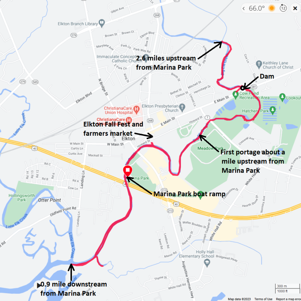
 |

|
Norma and I led eleven of her co-workers on a kayak trip. We launched from Jacksons Landing at Patuxent River Park and then paddled up the Patuxent River and Western Branch.
Our cloud-covered launch site, shown below, was just west of Jug Bay, which is located near the mid-point of the 115-mile long Patuxent River, the longest river contained entirely within Maryland. The water that flows past Savage eventually passes here. Here are some views of our trip. At various stops, I spoke about spatterdock, beavers, muskrats, ospreys, great blue herons, the old bridge pivot, and Pig Point. I tried to make things both interesting and educational. Norma made a delicious lunch for everyone, which we ate at Mount Calvert Historical and Archaeological Park. Mount Calvert was designated the first seat of Prince George's County, Maryland in 1696 and named "Charles Town." The brick house at this site was built around 1789. Here's a shot of us at Mount Calvert with the Patuxent River in the background. I did a short quiz to see who was paying attention. Those who got answers correct won a prize. Back in our boats on the Western Branch, we were ready to start heading back. James seemed to be a pretty strong paddler. This is him on the Patuxent River. James caught a ride down with Norma, Daphne, and me so he hung with us while the others left. We climbed up to the observation tower to get a bird's eye view of the area. At the viewing platform, we saw this sign. Every arrowhead shown here represents the presence of a Native American campsite. This area attracted Algonquin-speaking tribes like the Patuxent, Mataponi, and Piscataway. Here's a view from the tower showing Mount Calvert in the distance. At the Patuxent River Park Rural Life Museums, we ran into Jenny P.W. who was demonstrating her blacksmithing skills. Here's our route. We paddled 3.6 miles. For more information on this area, read Mount Calvert Historical and Archaeological Park - Prime Real Estate. 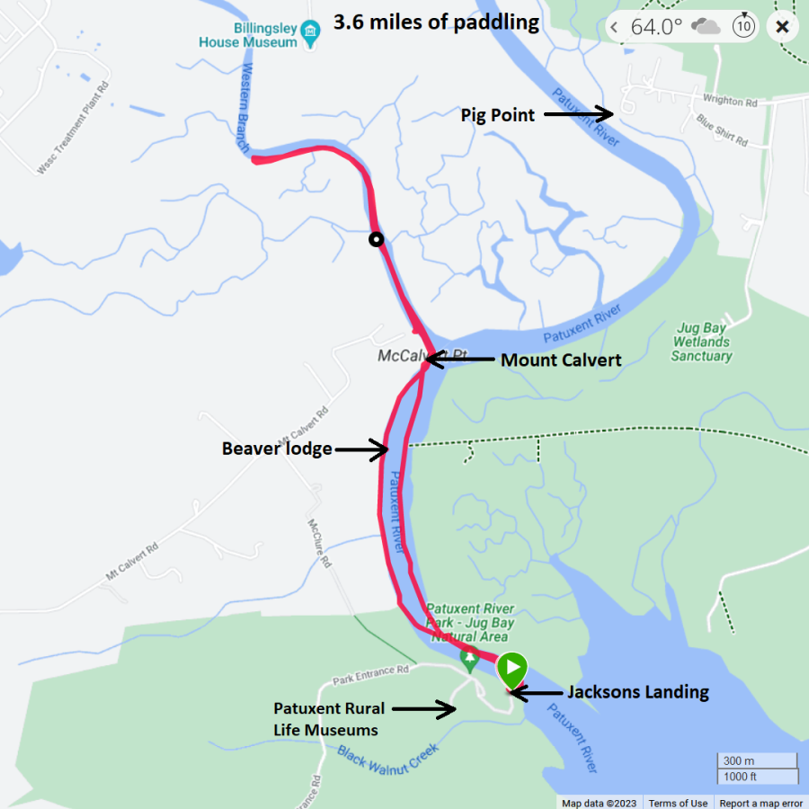
Norma put a lot of work into this trip. I was glad to be able to help her out. I think it was a big success. For more information, see Savage Mill - Patuxent Outing: Challenge Accepted!.  |

|
Christine from one of the local SUP groups organized an event called a SUP Pup Cup. I thought it would be nice to meet other paddleboarders with dogs so I attended. It ended up just being Daphne, a woman by the name of Lane, Christine, and Christine's dog, Maggie. We launched from Christine's back yard and paddled on the Magothy River.
I saw a juvenile little blue heron. This is only the second time I've seen one. At first, I thought this was a snowy egret but I didn't see bright yellow feet and no yellow around its beak. Snowies have black bills with a yellow patch, or lore, between their beaks and eyes, and yellow feet with black legs (mostly all black, but sometimes just black on the front of their legs!) Young Little Blues have gray-green legs, darker gray-to-black bills that are slightly thicker. Amy's Bird Blog - Compare: Little Blue Heron and Snowy Egret The three humans and two dogs paddled 3.8 miles. Still wanting to stay outside, Daphne and I launched from Locust Cove in Downs Park and paddled another 7.3 miles on Bodkin Creek. Then we walked about three miles in Downs Park, enjoying the sun, clear skies, and dry weather. 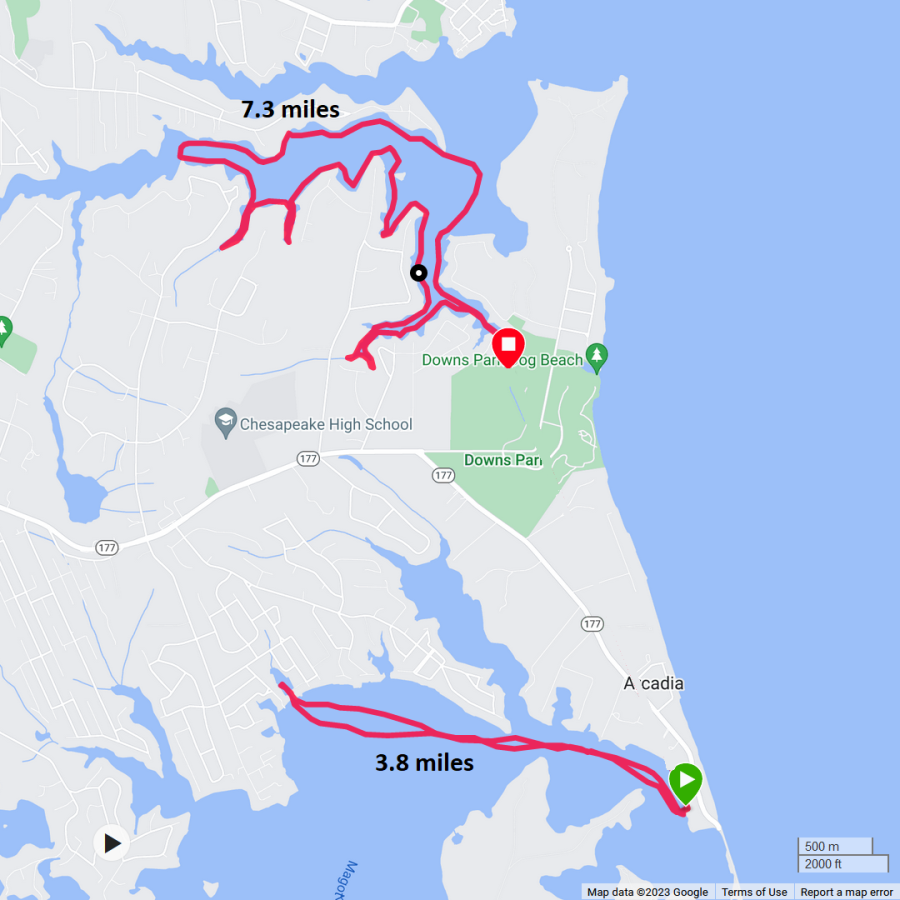
 |

|
I left work a little early to get out and enjoy the beautiful day. I launched my surf ski from Jackson Creek Landing. In the picture below, notice the kanji on my paddle. It says "saki." No kayak trip on brackish water would be complete without seeing at least one horseshoe crab...even a dead one. I saw several turtle egg shells. Do you see the prickly things at the bottom of the snapshot above? I managed to step on some of them with my bare feet. Not good. I had to wait until I got home for Norma to pull out one of the thorns. American persimmons were glowing orange. I paddled under highway 50...the same one that leads to where I grew up in California. US 50 paves 3,000-plus miles from Ocean City, Maryland to Sacramento, California, but there's more to the story. This sign ended up costing the state quite a bit of money because it kept getting stolen. According to a 2002 article in the Sacramento Bee, the sign was stolen twice, once in 1999 and then again two years later. Caltrans redesigned the sign to include the distances to Placerville and South Lake Tahoe, making it bigger and harder to throw in the back of a truck. But when the new sign went up there was a problem with the mileage. Instead of 3,073 miles to Ocean City, the sign incorrectly read 3,037. Caltrans noticed the error and placed a cover over the last two numbers correcting the mistake. - from Cap Radio - Two Coasts, Two Cities, Two Signs: The Story Behind The 'Ocean City MD 3073' Sign There's not much documentation about this lighthouse below. I didn't think it was historic or even be functional. It is located in a residential community at 101 Captains Way, Chester, MD 21619. I found a page describing it as a replica of one at Kent Island, Queensland, Australia. Unfortunately, I was not able to find a photo of the original to confirm. My guess is that Kent Island, Queensland, Australia is like a sister city to Kent Island, Maryland, even though they aren't cities. I later found out it is actually a water tower. The osprey have flown south but there are plenty of bald eagles to see. Here's one I saw as the sun was getting low in the sky. I landed a little before sunset. Here's my route. I got in 11.8 miles. 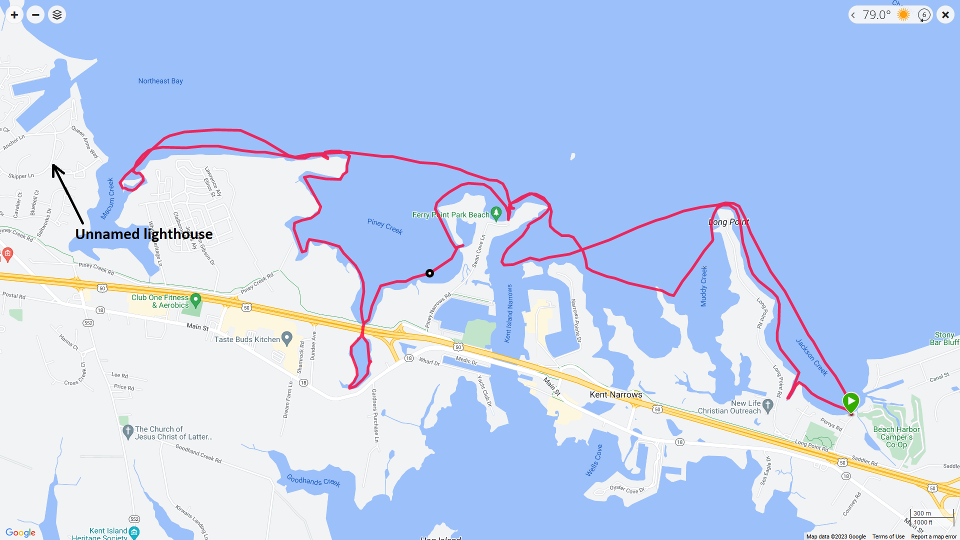
Brad Paisley says there's a last time for everything and after this trip, I decided it would be my last surf ski trip. I've had lots of problems with my left shoulder and paddling this boat aggravates it. It took over a week just to recover from this moderate trip. If I had better torso rotation, it might not be an issue but I don't think that is going to change. I know lots of sea kayakers use Greenland paddles because they say it is easier on their shoulders but wing paddles help with stability, which my surf ski lacks. I know my other kayaks aren't as much of a problem but if they end up being so, then I might get an outrigger canoe. That might be a good alternative since the single blade paddling motion like that used on a SUP is much easier on my body. I'm sad to throw in the towel on surf skis but it has been a good run; I started in 2002.  |

|
I don't much care for autumn. I much prefer summer and I'm not ready to say goodbye to it.
It was 73 degrees when Daphne and I were out on the Patuxent River. We launched the SUP from Patuxent Wetlands Park and explored lots of places that would normally be difficult to access. Today, however, we could get to them because of the high tide and the dying back of the spatterdock. We saw various flowers and some red-winged blackbirds. Bees were really loving these. When we arrived, I parked on dry land, but the tide rose quite a bit while I was out on the water. The water came up to the bottom part of my engine. Good thing we weren't in Maine or the whole car might have been submerged. We got in 6.8 miles. Here's our route. 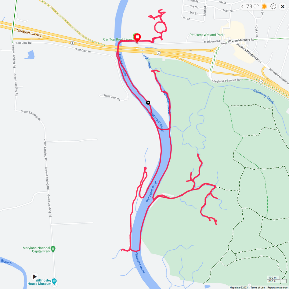
After paddling, we stopped at Wootons Landing Wetland Park where I took Daphne on a 1.8 mile sunset trail walk.  |

|
Daphne and I launched the SUP from Truslow/Hodson Boat House to see the ships at the Sultana Downrigging Tall Ships and Bluegrass Festival in Chestertown, Maryland. I've seen them in the morning light but this was the first time I saw them from the water in the late afternoon and early evening. Seeing them when they come back from tours is the best time to photograph them because many have their sails up. I was fortunate to have timed my visit perfectly to witness this.
Here they are in all their majestic glory. I got some multi-ship shots too. Things got really pretty as the sun got low in the sky.  |

|
I left work early and then went kayaking. I launched from Lynwood T. Kellam Memorial Recreation Park / Rod N' Reel Marina West in Calvert County, to look for fossils.
Things were pretty calm starting out. I paddled south and picked up a bit of a headwind. On the way back, the waves were coming from the southeast and they were much larger...some were two feet high. This made it tough since I did not have a rudder. Keeping my boat at 45 degrees to the waves gave me pretty good control but occasionally a big wave would turn me in a direction I did not want. So what all did I find? I returned with 98 shark teeth, along with a few other fossils. These are roughly 10 to 20 million years old and from the Miocene epoch. I usually find at least 100 in the area I searched but I don't think it is so fruitful since there are more developments in the area with community beach access. It may not be open to the general public but there are certainly enough local folks out there picking the low-hanging fruit. Almost everything I found was from sifting. My favorite find was not a shark tooth but rather a dolphin tooth fossil. It is 1.0625 inches long. I noticed one was for sale on-line for $40. Like most shark tooth hunters, my goal is to find a large, pristine megalodon tooth. But after that, my favorite shark tooth is from a cow shark. I was fortunate to find this fine specimen. When people ask me what to look for, I reply with "dark triangles." The dark colors of a shark tooth fossil come from absorbing minerals found in the ground around them. But I came back with a couple of exceptions. Here are five other shark teeth which I think are worth mentioning. The top teeth are from tiger sharks while the lower ones on the side are likely from snaggletooth sharks. Notice their serrations. I don't find teeth with this kind of detail when I'm looking on the Potomac River in Charles County. Not sure what the one in the middle is but I like the colors. The little side nubs indicate this is from a sand shark. Back in Chesapeake Beach, I kayaked past the Devil Ray TWR-6 torpedo retriever. United States Navy submarines, surface ships, and aircraft launch torpedoes, missiles, and autonomous undersea vehicles as part of training exercises. Typically, these training munitions have no warhead and are recovered from the sea and reused. Similarly, new naval weapons under development are launched at sea in performance trials. These experimental units also need to be recovered, in their case to obtain evaluation data. At various points in history, newly manufactured torpedoes were fired as a quality control measure and these, too, had to be recovered before issuing them to the fleet. The U.S. Navy has used a variety of boats to accomplish the retrieval of these test and training munitions. As their missions evolved over the last century they have been variously known as torpedo retrievers, torpedo weapon retrievers, torpedo recovery boats, range support craft, and multi-purpose craft. - from Wikipedia - United States Navy torpedo retrievers I kayaked 9.8 miles.  |

|
I paddled my SUP in a couple of unnamed tributaries on the Talbot County side of the Choptank River. I launched from Kingston Landing. My goal was to find the observation tower marking the southwest terminus of a defunct boardwalk.
During my first visit, in 2006, visitors could walk a short distance south from the [Kings Creek Nature Conservancy] pier to a 2000-foot-long floating boardwalk leading to an observation tower in Kings Creek Preserve, part of a larger tract known as the Choptank Wetlands Preserve, established in 1978. In 2022, I spoke to Dr. Deborah Landau, conservation ecologist with the Nature Conservancy, about the now-decrepit boardwalk. With upkeep proving too costly, there were plans to give this property to the county with the understanding that they would maintain it. Unfortunately, the transfer fell through, and a few years later, the boardwalk was permanently closed. - from Kings Creek - A Water Trail Fit for Royalty I thought about bringing Daphne on this trip but I was concerned there might be gunfire because it was hunting season. I did indeed hear shots but they were very far away. My last trip out here was on June 30, 2023. Back then, I was also looking for the observation tower but I ended up exploring the wrong creek and then finding a SUP which I retrieved. But from that trip, I knew that if I came to a duck blind, then I went one creek to far. So I returned to the duck blind, saw the creek right by it, and then made my way back up the Choptank. I explored the next unnamed creek just upstream. This was the one I wanted. I kept my eyes peeled for the observation tower but never saw it. But I was quite certain it was still there because it shows up very clearly in satellite photos. They were probably hidden by the tall phragmites which grow right up to the water and make seeing things further inland difficult. Despite not finding the observation tower, I still had a very good trip. I got much further upstream than I expected. Narrow, winding waterways with fairly homogenous vegetation led me to two wide, swampy areas at the treeline. This is definitely a high-tide trip and a fun place to explore. I saw numerous muskrat mounds but I did not see any muskrats. I did, however, see several turtles, a falcon, some wood ducks, and lots of other waterfowl. I explored the next creek upstream. I paddled this once before when I was gathering info to write about Kings Creek for the Chesapeake Conservancy. This creek has much more diverse vegetation than the other one. I revisited the floating boardwalk. Below is the best view of the boardwalk. It is NOT safe for walking. In a few places, you can see posts that once held this floating boardwalk in place. Here's my route. I paddled 8.2 miles. 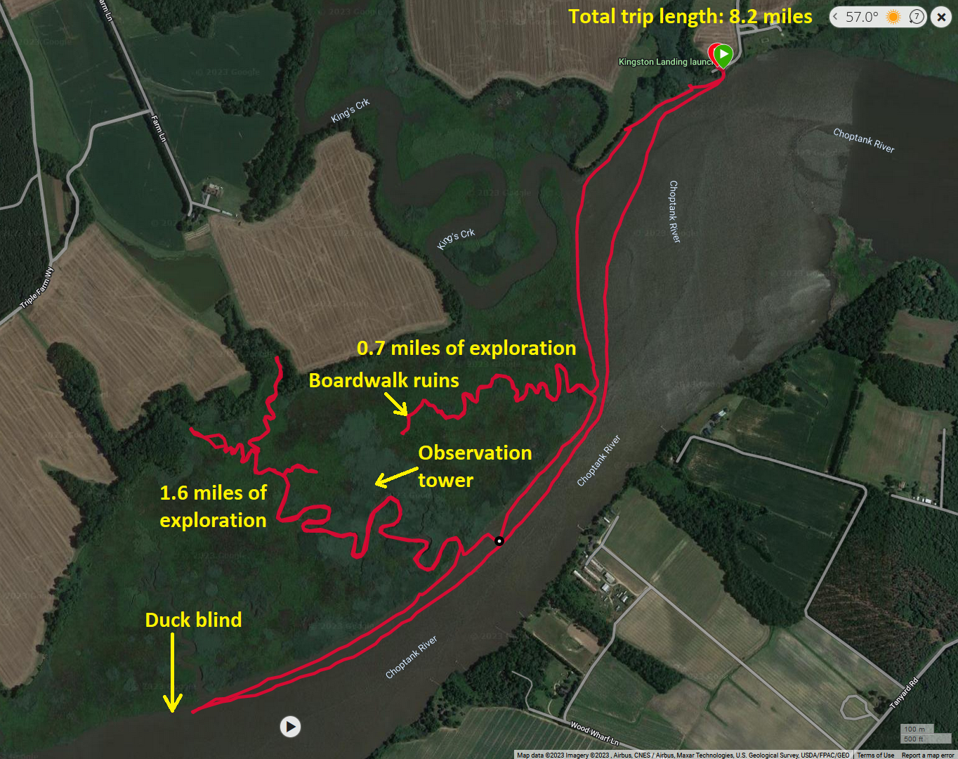
It was a lovely day to be out. I don't usually paddle this late in the year but my schedule is a little messed up because of the home renovation taking place at my house. We have a lot of stuff moved to the garage so I can't easily do my annual boat/gear cleaning and maintenance. So I figured I'd keep paddling if the opportunity presents itself.  |